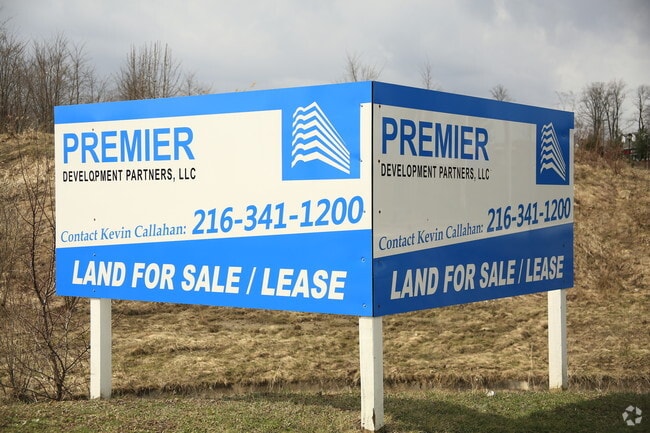
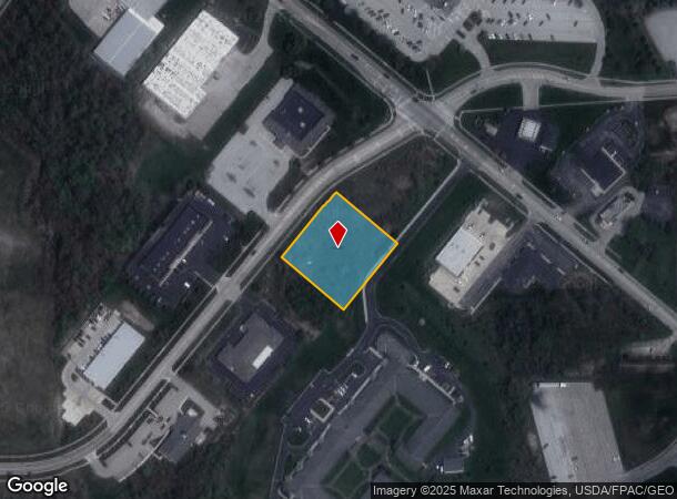
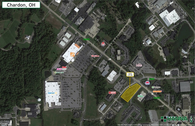
Property Record
511 5Th Ave, Chardon, OH 44024
NEARBY LISTINGS FOR SALE OR LEASE
Property Detail
511 5Th Ave
Cleveland-Elyria, OH
Chardon
10-165641
PARCEL A CHARDON PARK SUB RESUB
Commercialacreage
Geauga
X
Ohio
39055C0128D
1.11 AC
2024
Geauga County
2024
Cleveland
312201
DEMOGRAPHICS near 511 5Th Ave
1 Mile
3 Mile
5 Mile
2024 Total Population
2,589
12,572
23,902
2029 Population
2,617
12,647
24,005
Pop Growth 2024-2029
+ 1.08%
+ 0.60%
+ 0.43%
Average Age
45
44
44
2024 Total Households
1,229
5,162
9,397
HH Growth 2024-2029
+ 0.98%
+ 0.54%
+ 0.37%
Median Household Inc
$58,894
$88,257
$97,139
Avg Household Size
2.00
2.30
2.50
2024 Avg HH Vehicles
2.00
2.00
2.00
Median Home Value
$252,127
$266,115
$283,292
Median Year Built
1969
1978
1982
Nearby Places
- Restaurants
- Banks
- Shops
- Fitness
- Groceries
SALE & LEASE HISTORY
LISTING DATE
SALE/LEASE

Sep 24, 2016
For Sale
Oct 14, 2021
For Sale
Nov 20, 2020
For Lease
Nov 19, 2020
For Sale
Feb 02, 2018
For Sale
Dec 16, 2019
For Sale
Nearby Properties
Address
Land Use
TOTAL SIZE
Lot Size
Zoning
Address
Land Use
TOTAL SIZE
Lot Size
Zoning
188,150 SF
20.01 AC
C3
Address
Land Use
TOTAL SIZE
Lot Size
Zoning
70,289 SF
12.03 AC
PUD
Address
Land Use
TOTAL SIZE
Lot Size
Zoning
98,228 SF
20 AC
S
Address
Land Use
TOTAL SIZE
Lot Size
Zoning
123,170 SF
7.50 AC
S
Address
Land Use
TOTAL SIZE
Lot Size
Zoning
140,974 SF
15.62 AC
IWTTO
Address
Land Use
TOTAL SIZE
Lot Size
Zoning
50,048 SF
14.78 AC
C3
Address
Land Use
TOTAL SIZE
Lot Size
Zoning
960 SF
552.62 AC
Address
Land Use
TOTAL SIZE
Lot Size
Zoning
5,847 SF
14.15 AC
R2
Address
Land Use
TOTAL SIZE
Lot Size
Zoning
105,182 SF
10.64 AC
IWTTO
Address
Land Use
TOTAL SIZE
Lot Size
Zoning
1,870 SF
102.70 AC
R1
Address
Land Use
TOTAL SIZE
Lot Size
Zoning
106,658 SF
14.40 AC
C3
Address
Land Use
TOTAL SIZE
Lot Size
Zoning
8,618 SF
19.46 AC
Address
Land Use
TOTAL SIZE
Lot Size
Zoning
36,696 SF
10.30 AC
R3
Address
Land Use
TOTAL SIZE
Lot Size
Zoning
80,188 SF
5.83 AC
C3
Address
Land Use
TOTAL SIZE
Lot Size
Zoning
11,054 SF
10 AC
R1
Address
Land Use
TOTAL SIZE
Lot Size
Zoning
2,370 SF
43.96 AC
MHP
Address
Land Use
TOTAL SIZE
Lot Size
Zoning
35,159 SF
0.42 AC
R2
Address
Land Use
TOTAL SIZE
Lot Size
Zoning
55,768 SF
9.84 AC
C3
Address
Land Use
TOTAL SIZE
Lot Size
Zoning
8,964 SF
177.51 AC
R1
Address
Land Use
TOTAL SIZE
Lot Size
Zoning
6,840 SF
12.42 AC
R1
Address
Land Use
TOTAL SIZE
Lot Size
Zoning
29,878 SF
5.77 AC
C3
Address
Land Use
TOTAL SIZE
Lot Size
Zoning
38,367 SF
5.29 AC
C3
Address
Land Use
TOTAL SIZE
Lot Size
Zoning
66,551 SF
13.25 AC
PUD
Address
Land Use
TOTAL SIZE
Lot Size
Zoning
67,501 SF
6.59 AC
C3
Address
Land Use
TOTAL SIZE
Lot Size
Zoning
25,898 SF
2.26 AC
R2
Address
Land Use
TOTAL SIZE
Lot Size
Zoning
12,800 SF
7.50 AC
R4
Address
Land Use
TOTAL SIZE
Lot Size
Zoning
3,480 SF
9.30 AC
PUD
Address
Land Use
TOTAL SIZE
Lot Size
Zoning
68,539 SF
7.06 AC
IWTTO
Address
Land Use
TOTAL SIZE
Lot Size
Zoning
240 SF
188.67 AC
Address
Land Use
TOTAL SIZE
Lot Size
Zoning
19,001 SF
8.75 AC
R2
The World's #1 Commercial Real Estate Marketplace
Connect with us
© 2025 CoStar Group
The information above has been obtained from sources believed reliable. While we do not doubt its accuracy we have not verified it and make no guarantee, warranty or representation about it. It is your responsibility to independently confirm its accuracy and completeness. Any projections, opinions, assumptions, or estimates used are for example only and do not represent the current or future performance of the property. The value of this transaction to you depends on tax and other factors which should be evaluated by your tax, financial, and legal advisors. You and your advisors should conduct a careful, independent investigation of the property to determine to your satisfaction the suitability of the property for your needs.