Property Record
6 Barnes Corner Rd, Colora, MD 21917
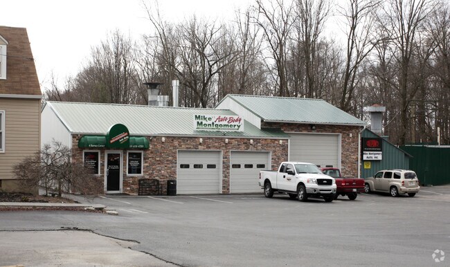
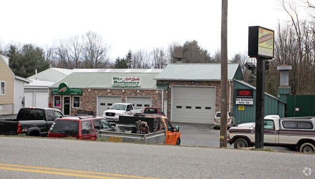
Property Detail
6 Barnes Corner Rd
06-014844
2.99 ACRES E/S JACOB TOME MEMORIAL NEAR WEST NOTTINGHAM
Storebuilding
Cecil
SPLIT
Maryland
B and X Area of moderate flood hazard, usually the area between the limits of the 100-year and 500-year floods.
8.03 AC
2025
Cecil County
2025
Baltimore
031301
Philadelphia-Camden-Wilmington, PA-NJ-DE-MD
2,180 SF
NEARBY LISTINGS FOR SALE OR LEASE
DEMOGRAPHICS near 6 Barnes Corner Rd
1 mile
3 mile
5 mile
2025 Total Population
1,521
9,576
21,341
2030 Population
1,525
9,602
21,601
Pop Growth 2025-2030
+ 0.26%
+ 0.27%
+ 1.22%
Average Age
42
42
42
2025 Total Households
559
3,517
7,837
HH Growth 2025-2030
+ 0.18%
+ 0.26%
+ 1.30%
Median Household Inc
$111,250
$105,322
$95,373
Avg Household Size
2.70
2.70
2.70
2025 Avg HH Vehicles
3.00
2.00
2.00
Median Home Value
$338,043
$337,701
$331,852
Median Year Built
1973
1981
1985
Nearby Places
Map Layers
Map Styles
 Street
 Aerial
Transit
 Traffic
 Biking
Places
Listings with unknown addresses are not visible on the map
- Restaurants
- Banks
- Shops
- Fitness
- Groceries
PUBLIC TRANSPORTATION
COMMUTER RAIL
Drive
Walk
Distance
15 min
8.9 mi
Freight Ports
Port Newark Container Terminal
Drive
Walk
Distance
Port Newark Container Terminal
26 min
14.1 mi
Nearby Properties
Address
Land Use
TOTAL SIZE
Lot Size
Zoning
Address
Land Use
TOTAL SIZE
Lot Size
Zoning
63,314 SF
17.52 AC
CC
Address
Land Use
TOTAL SIZE
Lot Size
Zoning
12,128 SF
56.42 AC
NAR
Address
Land Use
TOTAL SIZE
Lot Size
Zoning
108,477 SF
10.04 AC
R1
Address
Land Use
TOTAL SIZE
Lot Size
Zoning
66,647 SF
12.05 AC
RR
Address
Land Use
TOTAL SIZE
Lot Size
Zoning
68,310 SF
2.97 AC
L1
Address
Land Use
TOTAL SIZE
Lot Size
Zoning
11,972 SF
7.84 AC
R3
Address
Land Use
TOTAL SIZE
Lot Size
Zoning
14,836 SF
6.45 AC
R1 R3
Address
Land Use
TOTAL SIZE
Lot Size
Zoning
9,107 SF
16.12 AC
CC
Address
Land Use
TOTAL SIZE
Lot Size
Zoning
19,965 SF
12.71 AC
RR
Address
Land Use
TOTAL SIZE
Lot Size
Zoning
13,064 SF
0.58 AC
CC
Address
Land Use
TOTAL SIZE
Lot Size
Zoning
3,706 SF
10 AC
RR
Address
Land Use
TOTAL SIZE
Lot Size
Zoning
7,131 SF
1.70 AC
LI
Address
Land Use
TOTAL SIZE
Lot Size
Zoning
6,000 SF
0.15 AC
CC
Address
Land Use
TOTAL SIZE
Lot Size
Zoning
4,520 SF
2.05 AC
R3
Address
Land Use
TOTAL SIZE
Lot Size
Zoning
5,200 SF
1.91 AC
LC
Address
Land Use
TOTAL SIZE
Lot Size
Zoning
8 AC
R3
Address
Land Use
TOTAL SIZE
Lot Size
Zoning
15,416 SF
1 AC
R3
Address
Land Use
TOTAL SIZE
Lot Size
Zoning
6,080 SF
3.56 AC
NAR
Address
Land Use
TOTAL SIZE
Lot Size
Zoning
9,060 SF
3.99 AC
BG
Address
Land Use
TOTAL SIZE
Lot Size
Zoning
18,049 SF
5.35 AC
M1
Address
Land Use
TOTAL SIZE
Lot Size
Zoning
6,240 SF
24.52 AC
CC
Address
Land Use
TOTAL SIZE
Lot Size
Zoning
10,640 SF
3.98 AC
BG
Address
Land Use
TOTAL SIZE
Lot Size
Zoning
1,210 SF
1.21 AC
LI
Address
Land Use
TOTAL SIZE
Lot Size
Zoning
17,500 SF
12.32 AC
BG
Address
Land Use
TOTAL SIZE
Lot Size
Zoning
11,086 SF
0.99 AC
LC
Address
Land Use
TOTAL SIZE
Lot Size
Zoning
2,532 SF
1.73 AC
RR
Address
Land Use
TOTAL SIZE
Lot Size
Zoning
4.29 AC
R2
Address
Land Use
TOTAL SIZE
Lot Size
Zoning
23,400 SF
7.65 AC
SPLIT
Address
Land Use
TOTAL SIZE
Lot Size
Zoning
4,520 SF
1.79 AC
R3
The World's #1 Commercial Real Estate Marketplace
Connect with us
© 2026 CoStar Group
The information above has been obtained from sources believed reliable. While we do not doubt its accuracy we have not verified it and make no guarantee, warranty or representation about it. It is your responsibility to independently confirm its accuracy and completeness. Any projections, opinions, assumptions, or estimates used are for example only and do not represent the current or future performance of the property. The value of this transaction to you depends on tax and other factors which should be evaluated by your tax, financial, and legal advisors. You and your advisors should conduct a careful, independent investigation of the property to determine to your satisfaction the suitability of the property for your needs.