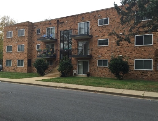
Property Record
6 Blair Rd, Indian Head, MD 20640


Save to a Folder
{{folder.Name}}
{{folder.ListingIds.length}} Properties
{{folder.ListingIds.length}} Property
Create a New Folder
Property Detail
6 Blair Rd
07-001819
.48 AC STRAUSS AVE INDIAN HEAD
Apartmenthouse5plusunits
Charles
RM
Maryland
B and X Area of moderate flood hazard, usually the area between the limits of the 100-year and 500-year floods.
0.48 AC
2025
Indian Head
2025
Washington, DC
850202
Washington-Arlington-Alexandria, DC-VA-MD-WV
10,872 SF
NEARBY LISTINGS FOR SALE OR LEASE
-
-
View all Indian Head listings for sale on LoopNet.com
DEMOGRAPHICS near 6 Blair Rd
1 mile
3 mile
5 mile
2025 Total Population
5,179
8,489
16,834
2030 Population
5,430
8,897
17,665
Pop Growth 2025-2030
+ 4.85%
+ 4.81%
+ 4.94%
Average Age
37
39
40
2025 Total Households
1,933
3,186
6,175
HH Growth 2025-2030
+ 5.02%
+ 4.99%
+ 5.07%
Median Household Inc
$76,762
$80,745
$98,264
Avg Household Size
2.60
2.60
2.70
2025 Avg HH Vehicles
2.00
2.00
2.00
Median Home Value
$234,569
$262,352
$338,702
Median Year Built
1979
1973
1984
Nearby Places
Map Layers
Map Styles
 Street
 Aerial
Layers
 Traffic
 Biking
Places
Listings with unknown addresses are not visible on the map
- Restaurants
- Banks
- Shops
- Fitness
- Groceries
PUBLIC TRANSPORTATION
AIRPORT
Ronald Reagan Washington Ntl
Drive
Walk
Distance
Ronald Reagan Washington Ntl
50 min
27.6 mi
Freight Ports
Port of Baltimore
Drive
Walk
Distance
Port of Baltimore
94 min
61.5 mi
Nearby Properties
Address
Land Use
TOTAL SIZE
Lot Size
Zoning
Address
Land Use
TOTAL SIZE
Lot Size
Zoning
3,395.07 AC
RL
Address
Land Use
TOTAL SIZE
Lot Size
Zoning
228,195 SF
50 AC
WCD
Address
Land Use
TOTAL SIZE
Lot Size
Zoning
91,173 SF
16.89 AC
RM
Address
Land Use
TOTAL SIZE
Lot Size
Zoning
4,864 SF
244.85 AC
100
Address
Land Use
TOTAL SIZE
Lot Size
Zoning
12,474 SF
453.08 AC
WCD
Address
Land Use
TOTAL SIZE
Lot Size
Zoning
56,050 SF
10.95 AC
P/I
Address
Land Use
TOTAL SIZE
Lot Size
Zoning
51,422 SF
21.65 AC
WCD
Address
Land Use
TOTAL SIZE
Lot Size
Zoning
29,292 SF
3.34 AC
GC
Address
Land Use
TOTAL SIZE
Lot Size
Zoning
56,434 SF
6.88 AC
RM
Address
Land Use
TOTAL SIZE
Lot Size
Zoning
106.10 AC
WCD
Address
Land Use
TOTAL SIZE
Lot Size
Zoning
17,088 SF
5.01 AC
GC
Address
Land Use
TOTAL SIZE
Lot Size
Zoning
26,408 SF
121.02 AC
IH,RC
Address
Land Use
TOTAL SIZE
Lot Size
Zoning
9,823 SF
3.50 AC
OS
Address
Land Use
TOTAL SIZE
Lot Size
Zoning
17,809 SF
3.14 AC
WCD
Address
Land Use
TOTAL SIZE
Lot Size
Zoning
4,845 SF
2.12 AC
CC
Address
Land Use
TOTAL SIZE
Lot Size
Zoning
30,618 SF
3.57 AC
R2
Address
Land Use
TOTAL SIZE
Lot Size
Zoning
9,244 SF
1 AC
CC
Address
Land Use
TOTAL SIZE
Lot Size
Zoning
13,000 SF
0.18 AC
TCMX
Address
Land Use
TOTAL SIZE
Lot Size
Zoning
19,210 SF
1.13 AC
P/I
Address
Land Use
TOTAL SIZE
Lot Size
Zoning
10,992 SF
1.55 AC
WCD
Address
Land Use
TOTAL SIZE
Lot Size
Zoning
17,593 SF
3.33 AC
WCD
Address
Land Use
TOTAL SIZE
Lot Size
Zoning
8,772 SF
1.84 AC
GC
Address
Land Use
TOTAL SIZE
Lot Size
Zoning
18,354 SF
1.03 AC
TCMX
Address
Land Use
TOTAL SIZE
Lot Size
Zoning
13,330 SF
1.36 AC
GC
Address
Land Use
TOTAL SIZE
Lot Size
Zoning
15,820 SF
2.85 AC
RM
Address
Land Use
TOTAL SIZE
Lot Size
Zoning
14,400 SF
0.77 AC
GC
Address
Land Use
TOTAL SIZE
Lot Size
Zoning
4,800 SF
2.20 AC
CC
Address
Land Use
TOTAL SIZE
Lot Size
Zoning
11,667 SF
1.19 AC
CC
Address
Land Use
TOTAL SIZE
Lot Size
Zoning
0.80 AC
100
Address
Land Use
TOTAL SIZE
Lot Size
Zoning
8,400 SF
0.67 AC
GC
The World's #1 Commercial Real Estate Marketplace
Connect with us
© 2026 CoStar Group
The information above has been obtained from sources believed reliable. While we do not doubt its accuracy we have not verified it and make no guarantee, warranty or representation about it. It is your responsibility to independently confirm its accuracy and completeness. Any projections, opinions, assumptions, or estimates used are for example only and do not represent the current or future performance of the property. The value of this transaction to you depends on tax and other factors which should be evaluated by your tax, financial, and legal advisors. You and your advisors should conduct a careful, independent investigation of the property to determine to your satisfaction the suitability of the property for your needs.