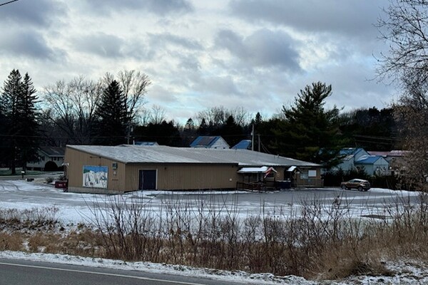
Property Record
6 Brooklyn St, Swanton, VT 05488


NEARBY LISTINGS FOR SALE OR LEASE
-
-
View all Swanton listings for sale on LoopNet.com
Property Detail
6 Brooklyn St
Other Market Areas
Franklin
Burlington-South Burlington, VT
Vermont
639-201-10075
2 AC
Residentialnec
Vermont North Area
9,342 SF
DEMOGRAPHICS near 6 Brooklyn St
1 Mile
3 Mile
5 Mile
2024 Total Population
3,243
5,136
8,956
2029 Population
3,396
5,383
9,399
Pop Growth 2024-2029
+ 4.72%
+ 4.81%
+ 4.95%
Average Age
41
41
42
2024 Total Households
1,325
2,076
3,550
HH Growth 2024-2029
+ 4.53%
+ 4.67%
+ 4.85%
Median Household Inc
$64,009
$67,815
$71,441
Avg Household Size
2.40
2.40
2.40
2024 Avg HH Vehicles
2.00
2.00
2.00
Median Home Value
$212,384
$226,434
$241,176
Median Year Built
1964
1970
1972
Nearby Places
Map Layers
Map Styles
 Street
 Aerial
- Restaurants
- Banks
- Shops
- Fitness
- Groceries
PUBLIC TRANSPORTATION
COMMUTER RAIL
St. Albans Amtrak Station (Vermonter - Amtrak)
DRIVE
WALK
Distance
St. Albans Amtrak Station (Vermonter - Amtrak)
12 min
9.5 mi
AIRPORT
Plattsburgh International
DRIVE
WALK
Distance
Plattsburgh International
58 min
46.9 mi
Freight Ports
Montreal
DRIVE
WALK
Distance
Montreal
85 min
63.7 mi
SALE & LEASE HISTORY
LISTING DATE
SALE/LEASE

Nov 04, 2024
For Sale
Dec 22, 2024
For Sale
Nearby Properties
Address
Land Use
TOTAL SIZE
Lot Size
Zoning
Address
Land Use
TOTAL SIZE
Lot Size
Zoning
39 AC
Address
Land Use
TOTAL SIZE
Lot Size
Zoning
67.10 AC
Address
Land Use
TOTAL SIZE
Lot Size
Zoning
17.03 AC
Address
Land Use
TOTAL SIZE
Lot Size
Zoning
15.43 AC
Address
Land Use
TOTAL SIZE
Lot Size
Zoning
105,828 SF
13.61 AC
Address
Land Use
TOTAL SIZE
Lot Size
Zoning
0.21 AC
Address
Land Use
TOTAL SIZE
Lot Size
Zoning
Address
Land Use
TOTAL SIZE
Lot Size
Zoning
1,168.98 AC
Address
Land Use
TOTAL SIZE
Lot Size
Zoning
2.90 AC
Address
Land Use
TOTAL SIZE
Lot Size
Zoning
Address
Land Use
TOTAL SIZE
Lot Size
Zoning
346.60 AC
Address
Land Use
TOTAL SIZE
Lot Size
Zoning
9.04 AC
Address
Land Use
TOTAL SIZE
Lot Size
Zoning
78,670 SF
13.39 AC
Address
Land Use
TOTAL SIZE
Lot Size
Zoning
5,368 SF
6.32 AC
Address
Land Use
TOTAL SIZE
Lot Size
Zoning
0.25 AC
Address
Land Use
TOTAL SIZE
Lot Size
Zoning
448.91 AC
Address
Land Use
TOTAL SIZE
Lot Size
Zoning
5.73 AC
Address
Land Use
TOTAL SIZE
Lot Size
Zoning
8.86 AC
Address
Land Use
TOTAL SIZE
Lot Size
Zoning
Address
Land Use
TOTAL SIZE
Lot Size
Zoning
0.12 AC
Address
Land Use
TOTAL SIZE
Lot Size
Zoning
9,600 SF
1.60 AC
Address
Land Use
TOTAL SIZE
Lot Size
Zoning
19,628 SF
9.25 AC
Address
Land Use
TOTAL SIZE
Lot Size
Zoning
1.78 AC
Address
Land Use
TOTAL SIZE
Lot Size
Zoning
0.10 AC
Address
Land Use
TOTAL SIZE
Lot Size
Zoning
41,168 SF
4.20 AC
Address
Land Use
TOTAL SIZE
Lot Size
Zoning
3,200 SF
7.05 AC
Address
Land Use
TOTAL SIZE
Lot Size
Zoning
5,816 SF
1.61 AC
Address
Land Use
TOTAL SIZE
Lot Size
Zoning
17,612 SF
1.76 AC
Address
Land Use
TOTAL SIZE
Lot Size
Zoning
0.19 AC
Address
Land Use
TOTAL SIZE
Lot Size
Zoning
16,164 SF
1.71 AC
The World's #1 Commercial Real Estate Marketplace
Connect with us
© 2025 CoStar Group
The information above has been obtained from sources believed reliable. While we do not doubt its accuracy we have not verified it and make no guarantee, warranty or representation about it. It is your responsibility to independently confirm its accuracy and completeness. Any projections, opinions, assumptions, or estimates used are for example only and do not represent the current or future performance of the property. The value of this transaction to you depends on tax and other factors which should be evaluated by your tax, financial, and legal advisors. You and your advisors should conduct a careful, independent investigation of the property to determine to your satisfaction the suitability of the property for your needs.