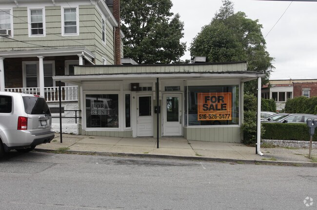
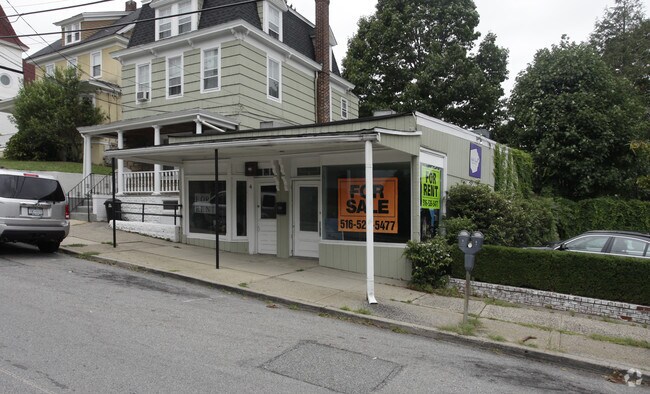
Property Record
6 Carlton Ave, Port Washington, NY 11050

NEARBY LISTINGS FOR SALE OR LEASE
Property Detail
6 Carlton Ave
2289-05-051-00-0052-0
TOWN #2 SCH DIST 004
Commercialnec
Nassau
X
New York
36059C0104G
52
2025
0.10 AC
2025
Western Nassau
301200
Long Island (New York)
2,712 SF
Nassau County-Suffolk County, NY
DEMOGRAPHICS near 6 Carlton Ave
1 Mile
3 Mile
5 Mile
2024 Total Population
15,650
64,688
177,866
2029 Population
15,494
63,799
175,322
Pop Growth 2024-2029
(1.00%)
(1.37%)
(1.43%)
Average Age
43
42
43
2024 Total Households
5,899
21,861
62,582
HH Growth 2024-2029
(0.90%)
(1.43%)
(1.52%)
Median Household Inc
$136,708
$156,426
$130,900
Avg Household Size
2.60
2.90
2.70
2024 Avg HH Vehicles
2.00
2.00
2.00
Median Home Value
$853,424
$1,015,024
$922,079
Median Year Built
1957
1955
1956
Nearby Places
- Restaurants
- Banks
- Shops
- Fitness
- Groceries
PUBLIC TRANSPORTATION
TRANSIT/SUBWAY
Port Washington Station (Port Washington Branch - Long Island Rail Road)
DRIVE
WALK
Distance
Port Washington Station (Port Washington Branch - Long Island Rail Road)
2 min
14 min
0.7 mi
COMMUTER RAIL
Port Washington Station (Port Washington Branch - Long Island Rail Road)
DRIVE
WALK
Distance
Port Washington Station (Port Washington Branch - Long Island Rail Road)
2 min
14 min
0.7 mi
Plandome Station (Port Washington Branch - Long Island Rail Road)
DRIVE
WALK
Distance
Plandome Station (Port Washington Branch - Long Island Rail Road)
5 min
2.2 mi
AIRPORT
LaGuardia
DRIVE
WALK
Distance
LaGuardia
29 min
16.6 mi
John F Kennedy International
DRIVE
WALK
Distance
John F Kennedy International
33 min
19.8 mi
Westchester County
DRIVE
WALK
Distance
Westchester County
58 min
35.7 mi
Freight Ports
NY - Red Hook Container Terminal
DRIVE
WALK
Distance
NY - Red Hook Container Terminal
41 min
24.7 mi
Nearby Properties
Address
Land Use
TOTAL SIZE
Lot Size
Zoning
Address
Land Use
TOTAL SIZE
Lot Size
Zoning
375,331 SF
14.83 AC
Address
Land Use
TOTAL SIZE
Lot Size
Zoning
251,828 SF
31.03 AC
Address
Land Use
TOTAL SIZE
Lot Size
Zoning
26,200 SF
186 AC
Address
Land Use
TOTAL SIZE
Lot Size
Zoning
196,507 SF
133.37 AC
Address
Land Use
TOTAL SIZE
Lot Size
Zoning
148,942 SF
34.17 AC
Address
Land Use
TOTAL SIZE
Lot Size
Zoning
84,302 SF
3.49 AC
Address
Land Use
TOTAL SIZE
Lot Size
Zoning
171,770 SF
5.95 AC
Address
Land Use
TOTAL SIZE
Lot Size
Zoning
179,365 SF
6.05 AC
Address
Land Use
TOTAL SIZE
Lot Size
Zoning
45,898 SF
85.13 AC
Address
Land Use
TOTAL SIZE
Lot Size
Zoning
98,439 SF
8.94 AC
Address
Land Use
TOTAL SIZE
Lot Size
Zoning
155,256 SF
25 AC
Address
Land Use
TOTAL SIZE
Lot Size
Zoning
56,663 SF
388.75 AC
Address
Land Use
TOTAL SIZE
Lot Size
Zoning
102,595 SF
21.45 AC
Address
Land Use
TOTAL SIZE
Lot Size
Zoning
140,916 SF
3.14 AC
Address
Land Use
TOTAL SIZE
Lot Size
Zoning
114,248 SF
80.99 AC
Address
Land Use
TOTAL SIZE
Lot Size
Zoning
130,665 SF
9.91 AC
Address
Land Use
TOTAL SIZE
Lot Size
Zoning
52,275 SF
27.63 AC
Address
Land Use
TOTAL SIZE
Lot Size
Zoning
246,555 SF
1.93 AC
Address
Land Use
TOTAL SIZE
Lot Size
Zoning
133,941 SF
10.02 AC
Address
Land Use
TOTAL SIZE
Lot Size
Zoning
95,147 SF
207.90 AC
Address
Land Use
TOTAL SIZE
Lot Size
Zoning
123,240 SF
13.67 AC
Address
Land Use
TOTAL SIZE
Lot Size
Zoning
125,611 SF
11.23 AC
Address
Land Use
TOTAL SIZE
Lot Size
Zoning
215,166 SF
4.06 AC
Address
Land Use
TOTAL SIZE
Lot Size
Zoning
19,259 SF
12.22 AC
Address
Land Use
TOTAL SIZE
Lot Size
Zoning
215,694 SF
7.42 AC
Address
Land Use
TOTAL SIZE
Lot Size
Zoning
70,230 SF
15.20 AC
Address
Land Use
TOTAL SIZE
Lot Size
Zoning
81,403 SF
3.09 AC
Address
Land Use
TOTAL SIZE
Lot Size
Zoning
6,278 SF
25.30 AC
Address
Land Use
TOTAL SIZE
Lot Size
Zoning
76,394 SF
12.86 AC
Address
Land Use
TOTAL SIZE
Lot Size
Zoning
81,285 SF
9.99 AC
The World's #1 Commercial Real Estate Marketplace
Connect with us
© 2025 CoStar Group
The information above has been obtained from sources believed reliable. While we do not doubt its accuracy we have not verified it and make no guarantee, warranty or representation about it. It is your responsibility to independently confirm its accuracy and completeness. Any projections, opinions, assumptions, or estimates used are for example only and do not represent the current or future performance of the property. The value of this transaction to you depends on tax and other factors which should be evaluated by your tax, financial, and legal advisors. You and your advisors should conduct a careful, independent investigation of the property to determine to your satisfaction the suitability of the property for your needs.