Property Record
6 Caufield Pl, Newtown, PA 18940
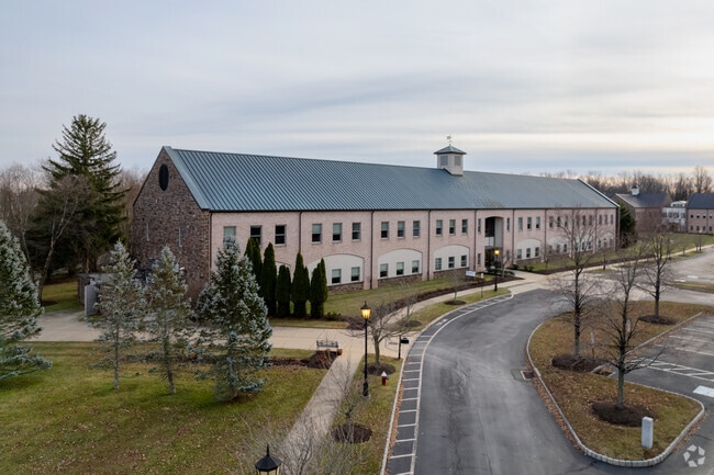

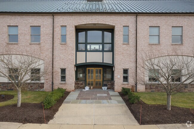
Property Detail
6 Caufield Pl
29-010-078
24.1A LOT W S LR09026 136 0 FT N SR332
Officebuilding
BUCKS
OR
Pennsylvania
AE The base floodplain where base flood elevations are provided. AE Zones are now used on new format FIRMs instead of A1-A30 Zones.
w
2024
24.10 AC
2025
Lower Bucks County
105206
Philadelphia
73,245 SF
Philadelphia-Camden-Wilmington, PA-NJ-DE-MD
NEARBY LISTINGS FOR SALE OR LEASE
DEMOGRAPHICS near 6 Caufield Pl
1 mile
3 mile
5 mile
2025 Total Population
3,323
43,381
121,481
2030 Population
3,318
43,500
122,325
Pop Growth 2025-2030
(0.15%)
+ 0.27%
+ 0.69%
Average Age
44
45
45
2025 Total Households
1,199
16,734
46,840
HH Growth 2025-2030
(0.17%)
+ 0.30%
+ 0.75%
Median Household Inc
$193,707
$148,501
$133,498
Avg Household Size
2.70
2.50
2.50
2025 Avg HH Vehicles
2.00
2.00
2.00
Median Home Value
$713,803
$672,420
$573,496
Median Year Built
1989
1986
1981
Nearby Places
Map Layers
Map Styles
 Street
 Aerial
Layers
 Traffic
 Biking
Places
Listings with unknown addresses are not visible on the map
- Restaurants
- Banks
- Shops
- Fitness
- Groceries
PUBLIC TRANSPORTATION
COMMUTER RAIL
Yardley (R3 - Southeastern Pennsylvania Transportation Authority Regional Rail (SEPTA Regional Rail))
Drive
Walk
Distance
Yardley (R3 - Southeastern Pennsylvania Transportation Authority Regional Rail (SEPTA Regional Rail))
10 min
4.6 mi
Woodbourne (R3 - Southeastern Pennsylvania Transportation Authority Regional Rail (SEPTA Regional Rail))
Drive
Walk
Distance
Woodbourne (R3 - Southeastern Pennsylvania Transportation Authority Regional Rail (SEPTA Regional Rail))
9 min
4.8 mi
AIRPORT
Trenton Mercer
Drive
Walk
Distance
Trenton Mercer
15 min
7.5 mi
Philadelphia International
Drive
Walk
Distance
Philadelphia International
59 min
39.5 mi
Freight Ports
Port of Philadelphia
Drive
Walk
Distance
Port of Philadelphia
39 min
25.8 mi
SALE & LEASE HISTORY
LISTING DATE
SALE/LEASE

Oct 10, 2018
For Lease
Oct 02, 2019
For Lease
Nov 16, 2022
For Lease
Nearby Properties
Address
Land Use
TOTAL SIZE
Lot Size
Zoning
Address
Land Use
TOTAL SIZE
Lot Size
Zoning
4,982 SF
39 AC
C
Address
Land Use
TOTAL SIZE
Lot Size
Zoning
170,342 SF
28.26 AC
PC
Address
Land Use
TOTAL SIZE
Lot Size
Zoning
10,350 SF
35.55 AC
R4
Address
Land Use
TOTAL SIZE
Lot Size
Zoning
58,221 SF
14.42 AC
R1
Address
Land Use
TOTAL SIZE
Lot Size
Zoning
21.78 AC
R4
Address
Land Use
TOTAL SIZE
Lot Size
Zoning
381,016 SF
52.25 AC
OR
Address
Land Use
TOTAL SIZE
Lot Size
Zoning
113,929 SF
10.43 AC
VRI
Address
Land Use
TOTAL SIZE
Lot Size
Zoning
104,466 SF
1.81 AC
OR
Address
Land Use
TOTAL SIZE
Lot Size
Zoning
57,804 SF
20.69 AC
AO
Address
Land Use
TOTAL SIZE
Lot Size
Zoning
102,348 SF
0.60 AC
RA
Address
Land Use
TOTAL SIZE
Lot Size
Zoning
104,204 SF
12.99 AC
RA3
Address
Land Use
TOTAL SIZE
Lot Size
Zoning
162,990 SF
10.75 AC
LI
Address
Land Use
TOTAL SIZE
Lot Size
Zoning
104,466 SF
1.91 AC
OR
Address
Land Use
TOTAL SIZE
Lot Size
Zoning
92,479 SF
11.48 AC
Address
Land Use
TOTAL SIZE
Lot Size
Zoning
131,927 SF
14.73 AC
LI
Address
Land Use
TOTAL SIZE
Lot Size
Zoning
106,250 SF
14.41 AC
OR
Address
Land Use
TOTAL SIZE
Lot Size
Zoning
94,737 SF
1.66 AC
OR
Address
Land Use
TOTAL SIZE
Lot Size
Zoning
11.77 AC
R1
Address
Land Use
TOTAL SIZE
Lot Size
Zoning
151,803 SF
12.54 AC
LI
Address
Land Use
TOTAL SIZE
Lot Size
Zoning
65,124 SF
8.52 AC
PG
Address
Land Use
TOTAL SIZE
Lot Size
Zoning
80,071 SF
17.46 AC
R2
Address
Land Use
TOTAL SIZE
Lot Size
Zoning
35,713 SF
7.09 AC
L1
Address
Land Use
TOTAL SIZE
Lot Size
Zoning
78,848 SF
0.70 AC
Address
Land Use
TOTAL SIZE
Lot Size
Zoning
64,164 SF
8.29 AC
PC
Address
Land Use
TOTAL SIZE
Lot Size
Zoning
1.31 AC
OR
Address
Land Use
TOTAL SIZE
Lot Size
Zoning
109,704 SF
14.12 AC
LI
Address
Land Use
TOTAL SIZE
Lot Size
Zoning
114,710 SF
10.93 AC
R4
Address
Land Use
TOTAL SIZE
Lot Size
Zoning
90,400 SF
10.46 AC
OR
Address
Land Use
TOTAL SIZE
Lot Size
Zoning
76,984 SF
1.23 AC
OR
The World's #1 Commercial Real Estate Marketplace
Connect with us
© 2026 CoStar Group
The information above has been obtained from sources believed reliable. While we do not doubt its accuracy we have not verified it and make no guarantee, warranty or representation about it. It is your responsibility to independently confirm its accuracy and completeness. Any projections, opinions, assumptions, or estimates used are for example only and do not represent the current or future performance of the property. The value of this transaction to you depends on tax and other factors which should be evaluated by your tax, financial, and legal advisors. You and your advisors should conduct a careful, independent investigation of the property to determine to your satisfaction the suitability of the property for your needs.