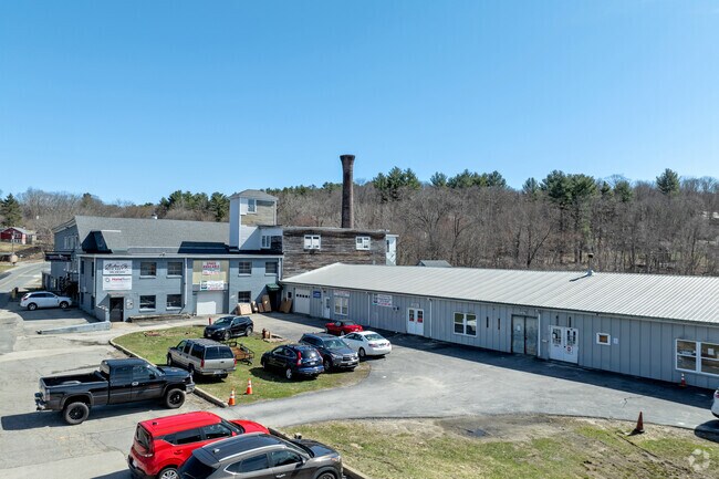
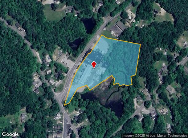
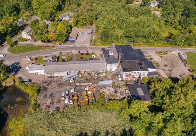
Property Record
6 City Depot Rd, Charlton, MA 01507

NEARBY LISTINGS FOR SALE OR LEASE
Property Detail
6 City Depot Rd
CHAR-000026BA000000-000001
Worcester
Industrialgeneral
Massachusetts
A
1
25027C0788F
5.70 AC
2025
Outlying Worcester
2025
Boston
756102
Worcester, MA-CT
58,588 SF
DEMOGRAPHICS near 6 City Depot Rd
1 Mile
3 Mile
5 Mile
2024 Total Population
1,926
8,036
21,259
2029 Population
1,896
7,948
21,095
Pop Growth 2024-2029
(1.56%)
(1.10%)
(0.77%)
Average Age
45
43
42
2024 Total Households
785
3,053
8,175
HH Growth 2024-2029
(1.66%)
(1.15%)
(0.83%)
Median Household Inc
$101,543
$109,424
$107,018
Avg Household Size
2.30
2.60
2.50
2024 Avg HH Vehicles
2.00
2.00
2.00
Median Home Value
$376,785
$395,199
$393,534
Median Year Built
1980
1981
1980
Nearby Places
Map Layers
Map Styles
 Street
 Aerial
- Restaurants
- Banks
- Shops
- Fitness
- Groceries
PUBLIC TRANSPORTATION
AIRPORT
Worcester Regional
DRIVE
WALK
Distance
Worcester Regional
27 min
13.7 mi
Freight Ports
Port of Davisville, RI
DRIVE
WALK
Distance
Port of Davisville, RI
91 min
68.1 mi
SALE & LEASE HISTORY
LISTING DATE
SALE/LEASE

Sep 19, 2022
For Sale
Mar 27, 2024
For Sale
Jun 28, 2017
For Lease
Nearby Properties
Address
Land Use
TOTAL SIZE
Lot Size
Zoning
Address
Land Use
TOTAL SIZE
Lot Size
Zoning
15,648 SF
50.82 AC
A
Address
Land Use
TOTAL SIZE
Lot Size
Zoning
167,936 SF
46.89 AC
A
Address
Land Use
TOTAL SIZE
Lot Size
Zoning
189,270 SF
97.55 AC
FB
Address
Land Use
TOTAL SIZE
Lot Size
Zoning
198,432 SF
91 AC
A
Address
Land Use
TOTAL SIZE
Lot Size
Zoning
90,414 SF
87.10 AC
A
Address
Land Use
TOTAL SIZE
Lot Size
Zoning
104,471 SF
29.98 AC
A
Address
Land Use
TOTAL SIZE
Lot Size
Zoning
195.60 AC
IG
Address
Land Use
TOTAL SIZE
Lot Size
Zoning
118,826 SF
35.73 AC
IP
Address
Land Use
TOTAL SIZE
Lot Size
Zoning
22,593 SF
32.50 AC
R40
Address
Land Use
TOTAL SIZE
Lot Size
Zoning
63.02 AC
R40
Address
Land Use
TOTAL SIZE
Lot Size
Zoning
45.59 AC
IG
Address
Land Use
TOTAL SIZE
Lot Size
Zoning
19,511 SF
5.50 AC
V
Address
Land Use
TOTAL SIZE
Lot Size
Zoning
22,359 SF
3.09 AC
CB
Address
Land Use
TOTAL SIZE
Lot Size
Zoning
76,734 SF
7.75 AC
IG
Address
Land Use
TOTAL SIZE
Lot Size
Zoning
76.78 AC
IP
Address
Land Use
TOTAL SIZE
Lot Size
Zoning
2,267 SF
10 AC
A
Address
Land Use
TOTAL SIZE
Lot Size
Zoning
7,464 SF
73.37 AC
Address
Land Use
TOTAL SIZE
Lot Size
Zoning
22.15 AC
R40
Address
Land Use
TOTAL SIZE
Lot Size
Zoning
32,160 SF
7.10 AC
R40
Address
Land Use
TOTAL SIZE
Lot Size
Zoning
21,632 SF
0.50 AC
V
Address
Land Use
TOTAL SIZE
Lot Size
Zoning
6.35 AC
A
Address
Land Use
TOTAL SIZE
Lot Size
Zoning
13,300 SF
24.33 AC
A
Address
Land Use
TOTAL SIZE
Lot Size
Zoning
53,874 SF
8.50 AC
R40
Address
Land Use
TOTAL SIZE
Lot Size
Zoning
112.59 AC
A
Address
Land Use
TOTAL SIZE
Lot Size
Zoning
43.67 AC
A
Address
Land Use
TOTAL SIZE
Lot Size
Zoning
12,596 SF
2.48 AC
CB
Address
Land Use
TOTAL SIZE
Lot Size
Zoning
12.69 AC
CB
Address
Land Use
TOTAL SIZE
Lot Size
Zoning
12,800 SF
CB
Address
Land Use
TOTAL SIZE
Lot Size
Zoning
10,390 SF
2.19 AC
CB
Address
Land Use
TOTAL SIZE
Lot Size
Zoning
18,397 SF
2 AC
IP
The World's #1 Commercial Real Estate Marketplace
Connect with us
© 2025 CoStar Group
The information above has been obtained from sources believed reliable. While we do not doubt its accuracy we have not verified it and make no guarantee, warranty or representation about it. It is your responsibility to independently confirm its accuracy and completeness. Any projections, opinions, assumptions, or estimates used are for example only and do not represent the current or future performance of the property. The value of this transaction to you depends on tax and other factors which should be evaluated by your tax, financial, and legal advisors. You and your advisors should conduct a careful, independent investigation of the property to determine to your satisfaction the suitability of the property for your needs.