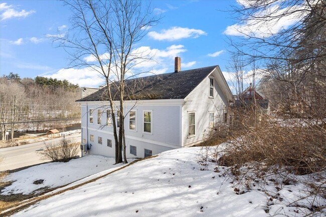
Property Record
6 Dawson St, Milton, NH 03851


Save to a Folder
{{folder.Name}}
{{folder.ListingIds.length}} Properties
{{folder.ListingIds.length}} Property
Create a New Folder
Property Detail
6 Dawson St
Commercialbuilding
Strafford
HIGH D
New Hampshire
B and X Area of moderate flood hazard, usually the area between the limits of the 100-year and 500-year floods.
0.13 AC
2025
Strafford County
2025
Boston
088000
Boston-Cambridge-Newton, MA-NH
3,070 SF
MLTN-000042-000104
NEARBY LISTINGS FOR SALE OR LEASE
DEMOGRAPHICS near 6 Dawson St
1 mile
3 mile
5 mile
2025 Total Population
1,011
5,164
14,369
2030 Population
1,015
5,223
14,554
Pop Growth 2025-2030
+ 0.40%
+ 1.14%
+ 1.29%
Average Age
42
43
43
2025 Total Households
392
2,064
5,811
HH Growth 2025-2030
+ 0.26%
+ 1.07%
+ 1.26%
Median Household Inc
$105,000
$96,826
$73,938
Avg Household Size
2.50
2.50
2.40
2025 Avg HH Vehicles
2.00
2.00
2.00
Median Home Value
$341,463
$349,549
$321,218
Median Year Built
1985
1983
1981
Nearby Places
Map Layers
Map Styles
 Street
 Aerial
Layers
 Traffic
 Biking
Places
Listings with unknown addresses are not visible on the map
- Restaurants
- Banks
- Shops
- Fitness
- Groceries
PUBLIC TRANSPORTATION
AIRPORT
Portsmouth International at Pease
Drive
Walk
Distance
Portsmouth International at Pease
42 min
29.2 mi
Portland International Jetport
Drive
Walk
Distance
Portland International Jetport
76 min
46.6 mi
Freight Ports
Portland, ME
Drive
Walk
Distance
Portland, ME
77 min
49.2 mi
SALE & LEASE HISTORY
LISTING DATE
SALE/LEASE

Sep 24, 2016
For Sale
Jan 23, 2018
For Lease
Nearby Properties
Address
Land Use
TOTAL SIZE
Lot Size
Zoning
Address
Land Use
TOTAL SIZE
Lot Size
Zoning
123,860 SF
8.75 AC
IND/CO
Address
Land Use
TOTAL SIZE
Lot Size
Zoning
3,000 SF
225 AC
LOW DE
Address
Land Use
TOTAL SIZE
Lot Size
Zoning
61,383 SF
9.60 AC
HIGH D
Address
Land Use
TOTAL SIZE
Lot Size
Zoning
56.70 AC
LOW DE
Address
Land Use
TOTAL SIZE
Lot Size
Zoning
60,884 SF
45.18 AC
LOW DE
Address
Land Use
TOTAL SIZE
Lot Size
Zoning
35,049 SF
4.61 AC
HIGH D
Address
Land Use
TOTAL SIZE
Lot Size
Zoning
6,000 SF
2.30 AC
IND/CO
Address
Land Use
TOTAL SIZE
Lot Size
Zoning
10,750 SF
2 AC
IND/CO
Address
Land Use
TOTAL SIZE
Lot Size
Zoning
2,583 SF
1.30 AC
LOW DE
Address
Land Use
TOTAL SIZE
Lot Size
Zoning
192,505 SF
25.50 AC
IND
Address
Land Use
TOTAL SIZE
Lot Size
Zoning
5,106 SF
3.65 AC
IND/CO
Address
Land Use
TOTAL SIZE
Lot Size
Zoning
14,895 SF
5.92 AC
IND/CO
Address
Land Use
TOTAL SIZE
Lot Size
Zoning
8,108 SF
3.18 AC
IND/CO
Address
Land Use
TOTAL SIZE
Lot Size
Zoning
5,413 SF
1.73 AC
HIGH D
Address
Land Use
TOTAL SIZE
Lot Size
Zoning
2,109 SF
1.80 AC
HIGH D
Address
Land Use
TOTAL SIZE
Lot Size
Zoning
8.06 AC
LOW DE
Address
Land Use
TOTAL SIZE
Lot Size
Zoning
33.99 AC
COMM/R
Address
Land Use
TOTAL SIZE
Lot Size
Zoning
0.23 AC
LOW DE
Address
Land Use
TOTAL SIZE
Lot Size
Zoning
12,863 SF
2.95 AC
HIGH D
Address
Land Use
TOTAL SIZE
Lot Size
Zoning
2,811 SF
71.23 AC
LOW DE
Address
Land Use
TOTAL SIZE
Lot Size
Zoning
485 SF
7.45 AC
LOW DE
Address
Land Use
TOTAL SIZE
Lot Size
Zoning
4,600 SF
0.63 AC
HIGH D
Address
Land Use
TOTAL SIZE
Lot Size
Zoning
1,922 SF
0.44 AC
LOW DE
Address
Land Use
TOTAL SIZE
Lot Size
Zoning
3,291 SF
1 AC
LOW DE
Address
Land Use
TOTAL SIZE
Lot Size
Zoning
7,328 SF
2.10 AC
HIGH D
Address
Land Use
TOTAL SIZE
Lot Size
Zoning
1,305 SF
0.83 AC
LOW DE
Address
Land Use
TOTAL SIZE
Lot Size
Zoning
4,634 SF
1.21 AC
HIGH D
Address
Land Use
TOTAL SIZE
Lot Size
Zoning
1,947 SF
0.49 AC
LOW DE
Address
Land Use
TOTAL SIZE
Lot Size
Zoning
2,375 SF
0.45 AC
LOW DE
Address
Land Use
TOTAL SIZE
Lot Size
Zoning
3,998 SF
9.05 AC
COMM/R
The World's #1 Commercial Real Estate Marketplace
Connect with us
© 2026 CoStar Group
The information above has been obtained from sources believed reliable. While we do not doubt its accuracy we have not verified it and make no guarantee, warranty or representation about it. It is your responsibility to independently confirm its accuracy and completeness. Any projections, opinions, assumptions, or estimates used are for example only and do not represent the current or future performance of the property. The value of this transaction to you depends on tax and other factors which should be evaluated by your tax, financial, and legal advisors. You and your advisors should conduct a careful, independent investigation of the property to determine to your satisfaction the suitability of the property for your needs.