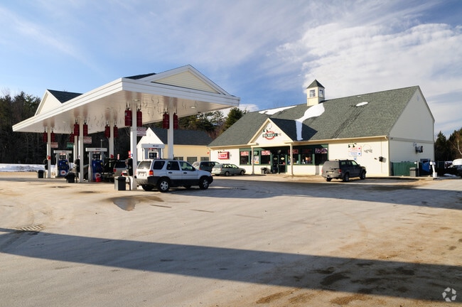
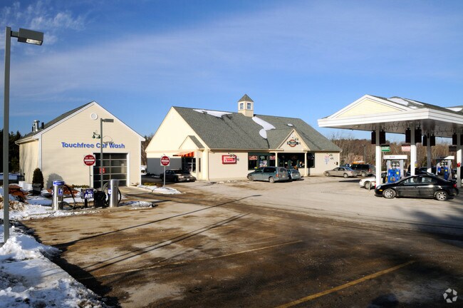
Property Record
6 Gardner Rd, Ashburnham, MA 01430

Property Detail
6 Gardner Rd
ASHB-000058-000000-000010
Worcester
Commercialnec
Massachusetts
B and X Area of moderate flood hazard, usually the area between the limits of the 100-year and 500-year floods.
5.52 AC
2025
Outlying Worcester
2025
Boston
700100
Worcester, MA
NEARBY LISTINGS FOR SALE OR LEASE
-
-
View all Ashburnham listings for sale on LoopNet.com
DEMOGRAPHICS near 6 Gardner Rd
1 mile
3 mile
5 mile
2025 Total Population
990
8,483
33,900
2030 Population
1,027
8,764
34,979
Pop Growth 2025-2030
+ 3.74%
+ 3.31%
+ 3.18%
Average Age
41
43
43
2025 Total Households
376
3,056
13,428
HH Growth 2025-2030
+ 3.99%
+ 3.57%
+ 3.33%
Median Household Inc
$116,071
$83,666
$76,659
Avg Household Size
2.50
2.40
2.40
2025 Avg HH Vehicles
2.00
2.00
2.00
Median Home Value
$384,425
$382,102
$356,484
Median Year Built
1990
1978
1964
Nearby Places
Map Layers
Map Styles
 Street
 Aerial
Transit
 Traffic
 Biking
Places
Listings with unknown addresses are not visible on the map
- Restaurants
- Banks
- Shops
- Fitness
- Groceries
PUBLIC TRANSPORTATION
COMMUTER RAIL
Wachusett (Fitchburg Line - MBTA)
Drive
Walk
Distance
Wachusett (Fitchburg Line - MBTA)
15 min
8.1 mi
AIRPORT
Worcester Regional
Drive
Walk
Distance
Worcester Regional
56 min
33.5 mi
Freight Ports
Port of Boston
Drive
Walk
Distance
Port of Boston
89 min
59.8 mi
Nearby Properties
Address
Land Use
TOTAL SIZE
Lot Size
Zoning
Address
Land Use
TOTAL SIZE
Lot Size
Zoning
321,793 SF
268 AC
Address
Land Use
TOTAL SIZE
Lot Size
Zoning
8.18 AC
Address
Land Use
TOTAL SIZE
Lot Size
Zoning
14.41 AC
Address
Land Use
TOTAL SIZE
Lot Size
Zoning
189,424 SF
12.60 AC
Address
Land Use
TOTAL SIZE
Lot Size
Zoning
104,279 SF
9.60 AC
Address
Land Use
TOTAL SIZE
Lot Size
Zoning
90,277 SF
23.30 AC
Address
Land Use
TOTAL SIZE
Lot Size
Zoning
164,401 SF
31 AC
Address
Land Use
TOTAL SIZE
Lot Size
Zoning
234 AC
Address
Land Use
TOTAL SIZE
Lot Size
Zoning
193,446 SF
17.34 AC
Address
Land Use
TOTAL SIZE
Lot Size
Zoning
89,712 SF
55.30 AC
Address
Land Use
TOTAL SIZE
Lot Size
Zoning
Address
Land Use
TOTAL SIZE
Lot Size
Zoning
4.47 AC
Address
Land Use
TOTAL SIZE
Lot Size
Zoning
16.03 AC
Address
Land Use
TOTAL SIZE
Lot Size
Zoning
8.17 AC
Address
Land Use
TOTAL SIZE
Lot Size
Zoning
12.83 AC
Address
Land Use
TOTAL SIZE
Lot Size
Zoning
108,598 SF
11.97 AC
Address
Land Use
TOTAL SIZE
Lot Size
Zoning
34,464 SF
0.76 AC
Address
Land Use
TOTAL SIZE
Lot Size
Zoning
152 AC
Address
Land Use
TOTAL SIZE
Lot Size
Zoning
3,280 SF
3.67 AC
Address
Land Use
TOTAL SIZE
Lot Size
Zoning
16.65 AC
Address
Land Use
TOTAL SIZE
Lot Size
Zoning
9.20 AC
Address
Land Use
TOTAL SIZE
Lot Size
Zoning
7.25 AC
Address
Land Use
TOTAL SIZE
Lot Size
Zoning
67,153 SF
6.83 AC
Address
Land Use
TOTAL SIZE
Lot Size
Zoning
24,220 SF
3.70 AC
Address
Land Use
TOTAL SIZE
Lot Size
Zoning
6,934 SF
5.01 AC
Address
Land Use
TOTAL SIZE
Lot Size
Zoning
17,524 SF
4.13 AC
Address
Land Use
TOTAL SIZE
Lot Size
Zoning
22,258 SF
3.13 AC
Address
Land Use
TOTAL SIZE
Lot Size
Zoning
5.82 AC
Address
Land Use
TOTAL SIZE
Lot Size
Zoning
1,196.27 AC
Address
Land Use
TOTAL SIZE
Lot Size
Zoning
14,400 SF
2.76 AC
The World's #1 Commercial Real Estate Marketplace
Connect with us
© 2026 CoStar Group
The information above has been obtained from sources believed reliable. While we do not doubt its accuracy we have not verified it and make no guarantee, warranty or representation about it. It is your responsibility to independently confirm its accuracy and completeness. Any projections, opinions, assumptions, or estimates used are for example only and do not represent the current or future performance of the property. The value of this transaction to you depends on tax and other factors which should be evaluated by your tax, financial, and legal advisors. You and your advisors should conduct a careful, independent investigation of the property to determine to your satisfaction the suitability of the property for your needs.