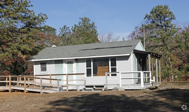
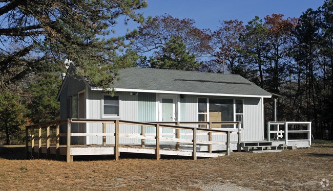
Property Record
6 Josiah Foster Path, East Quogue, NY 11942

NEARBY LISTINGS FOR SALE OR LEASE
Property Detail
6 Josiah Foster Path
Nassau County-Suffolk County, NY
N-RHEAD BLDG SPLY E-J FOSTERS PATH S-POINT W-BELTS RD & ORS
0900-317-00-01-00-026-000
Suffolk
Residentialacreage
New York
AE
26
36103C0777H
4.90 AC
0
Eastern Suffolk
2024
Long Island (New York)
190606
DEMOGRAPHICS near 6 Josiah Foster Path
1 Mile
3 Mile
5 Mile
2024 Total Population
4,284
14,016
35,779
2029 Population
4,372
14,275
36,859
Pop Growth 2024-2029
+ 2.05%
+ 1.85%
+ 3.02%
Average Age
44
43
42
2024 Total Households
1,668
5,373
13,214
HH Growth 2024-2029
+ 1.92%
+ 1.75%
+ 3.03%
Median Household Inc
$89,658
$99,473
$108,588
Avg Household Size
2.50
2.60
2.60
2024 Avg HH Vehicles
2.00
2.00
2.00
Median Home Value
$750,000
$755,116
$732,958
Median Year Built
1975
1976
1975
Nearby Places
- Restaurants
- Banks
- Shops
- Fitness
- Groceries
PUBLIC TRANSPORTATION
COMMUTER RAIL
Hampton Bays Station (Montauk Branch - Long Island Rail Road)
DRIVE
WALK
Distance
Hampton Bays Station (Montauk Branch - Long Island Rail Road)
5 min
3.5 mi
Westhampton Station (Montauk Branch - Long Island Rail Road)
DRIVE
WALK
Distance
Westhampton Station (Montauk Branch - Long Island Rail Road)
10 min
6.1 mi
AIRPORT
Long Island MacArthur
DRIVE
WALK
Distance
Long Island MacArthur
48 min
32.0 mi
Freight Ports
Port of New Haven
DRIVE
WALK
Distance
Port of New Haven
161 min
68.3 mi
Nearby Properties
Address
Land Use
TOTAL SIZE
Lot Size
Zoning
Address
Land Use
TOTAL SIZE
Lot Size
Zoning
47,996 SF
19.50 AC
R20
Address
Land Use
TOTAL SIZE
Lot Size
Zoning
660,340 SF
8.50 AC
MF44
Address
Land Use
TOTAL SIZE
Lot Size
Zoning
11,129 SF
2.40 AC
R80
Address
Land Use
TOTAL SIZE
Lot Size
Zoning
70,960 SF
8.29 AC
SCB
Address
Land Use
TOTAL SIZE
Lot Size
Zoning
6.28 AC
R80
Address
Land Use
TOTAL SIZE
Lot Size
Zoning
26.76 AC
CR200
Address
Land Use
TOTAL SIZE
Lot Size
Zoning
2,947 SF
8.59 AC
VILLA
Address
Land Use
TOTAL SIZE
Lot Size
Zoning
12,001 SF
2.80 AC
VILLA
Address
Land Use
TOTAL SIZE
Lot Size
Zoning
9,952 SF
2.30 AC
VILLA
Address
Land Use
TOTAL SIZE
Lot Size
Zoning
17,772 SF
8.86 AC
VILLA
Address
Land Use
TOTAL SIZE
Lot Size
Zoning
13.88 AC
CR200
Address
Land Use
TOTAL SIZE
Lot Size
Zoning
8,418 SF
2.40 AC
R80
Address
Land Use
TOTAL SIZE
Lot Size
Zoning
2.04 AC
VILLA
Address
Land Use
TOTAL SIZE
Lot Size
Zoning
9.30 AC
R80
Address
Land Use
TOTAL SIZE
Lot Size
Zoning
12.90 AC
R80
Address
Land Use
TOTAL SIZE
Lot Size
Zoning
24,396 SF
7.60 AC
R80
Address
Land Use
TOTAL SIZE
Lot Size
Zoning
30,124 SF
10.20 AC
R20
Address
Land Use
TOTAL SIZE
Lot Size
Zoning
19,866 SF
14.37 AC
LI200
Address
Land Use
TOTAL SIZE
Lot Size
Zoning
3.76 AC
R80
Address
Land Use
TOTAL SIZE
Lot Size
Zoning
67,796 SF
7 AC
SCB
Address
Land Use
TOTAL SIZE
Lot Size
Zoning
46,793 SF
11.42 AC
HB
Address
Land Use
TOTAL SIZE
Lot Size
Zoning
18.90 AC
R20
Address
Land Use
TOTAL SIZE
Lot Size
Zoning
150 SF
22.20 AC
R40
Address
Land Use
TOTAL SIZE
Lot Size
Zoning
1.34 AC
R80
Address
Land Use
TOTAL SIZE
Lot Size
Zoning
13,420 SF
2.05 AC
VILLA
Address
Land Use
TOTAL SIZE
Lot Size
Zoning
13,129 SF
2 AC
VB
Address
Land Use
TOTAL SIZE
Lot Size
Zoning
5.39 AC
VILLA
Address
Land Use
TOTAL SIZE
Lot Size
Zoning
30,140 SF
2.77 AC
VB
Address
Land Use
TOTAL SIZE
Lot Size
Zoning
2,400 SF
0.87 AC
R80
Address
Land Use
TOTAL SIZE
Lot Size
Zoning
6.47 AC
VILLA
The World's #1 Commercial Real Estate Marketplace
Connect with us
© 2025 CoStar Group
The information above has been obtained from sources believed reliable. While we do not doubt its accuracy we have not verified it and make no guarantee, warranty or representation about it. It is your responsibility to independently confirm its accuracy and completeness. Any projections, opinions, assumptions, or estimates used are for example only and do not represent the current or future performance of the property. The value of this transaction to you depends on tax and other factors which should be evaluated by your tax, financial, and legal advisors. You and your advisors should conduct a careful, independent investigation of the property to determine to your satisfaction the suitability of the property for your needs.