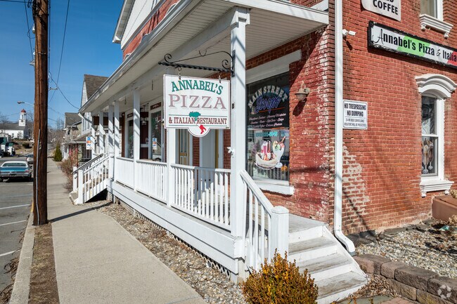
Property Record
6 Main St, Otisville, NY 10963


NEARBY LISTINGS FOR SALE OR LEASE
-
-
View all Otisville listings for sale on LoopNet.com
Property Detail
6 Main St
333801-101-000-0002-045.000-0000
INT ST HWY 84 & MAIN ST
Duplex
Orange
X
New York
34037C0066E
45.00
2024
0.38 AC
2024
Monroe
011500
Northern New Jersey
5,184 SF
Kiryas Joel-Poughkeepsie-Newburgh, NY
DEMOGRAPHICS near 6 Main St
1 mile
3 mile
5 mile
2024 Total Population
799
3,399
10,606
2029 Population
759
3,325
10,635
Pop Growth 2024-2029
(5.01%)
(2.18%)
+ 0.27%
Average Age
41
41
41
2024 Total Households
294
1,204
3,762
HH Growth 2024-2029
(5.10%)
(2.24%)
+ 0.37%
Median Household Inc
$96,052
$106,386
$113,676
Avg Household Size
2.70
2.80
2.80
2024 Avg HH Vehicles
2.00
3.00
2.00
Median Home Value
$371,052
$372,222
$353,267
Median Year Built
1974
1977
1979
Nearby Places
Map Layers
Map Styles
 Street
 Aerial
Transit
 Traffic
 Biking
Places
Listings with unknown addresses are not visible on the map
- Restaurants
- Banks
- Shops
- Fitness
- Groceries
PUBLIC TRANSPORTATION
AIRPORT
New York Stewart International
Drive
Walk
Distance
New York Stewart International
49 min
33.4 mi
Freight Ports
Port Newark Container Terminal
Drive
Walk
Distance
Port Newark Container Terminal
89 min
62.7 mi
SALE & LEASE HISTORY
LISTING DATE
SALE/LEASE

Jun 27, 2024
For Sale
Nearby Properties
Address
Land Use
TOTAL SIZE
Lot Size
Zoning
Address
Land Use
TOTAL SIZE
Lot Size
Zoning
10 AC
AR
Address
Land Use
TOTAL SIZE
Lot Size
Zoning
Address
Land Use
TOTAL SIZE
Lot Size
Zoning
4,142 SF
61.90 AC
AR
Address
Land Use
TOTAL SIZE
Lot Size
Zoning
274 AC
Address
Land Use
TOTAL SIZE
Lot Size
Zoning
1,200 SF
13.80 AC
AR
Address
Land Use
TOTAL SIZE
Lot Size
Zoning
15.30 AC
AR
Address
Land Use
TOTAL SIZE
Lot Size
Zoning
2,121 SF
147.79 AC
R-5
Address
Land Use
TOTAL SIZE
Lot Size
Zoning
Address
Land Use
TOTAL SIZE
Lot Size
Zoning
128.80 AC
AR
Address
Land Use
TOTAL SIZE
Lot Size
Zoning
5,000 SF
104.67 AC
Address
Land Use
TOTAL SIZE
Lot Size
Zoning
30.90 AC
AR
Address
Land Use
TOTAL SIZE
Lot Size
Zoning
780 SF
10.90 AC
R1
Address
Land Use
TOTAL SIZE
Lot Size
Zoning
70.10 AC
AR
Address
Land Use
TOTAL SIZE
Lot Size
Zoning
7,300 SF
4.70 AC
NC
Address
Land Use
TOTAL SIZE
Lot Size
Zoning
5,418 SF
1 AC
R-5
Address
Land Use
TOTAL SIZE
Lot Size
Zoning
9,253 SF
157.60 AC
AR
Address
Land Use
TOTAL SIZE
Lot Size
Zoning
7,174 SF
1 AC
R-5
Address
Land Use
TOTAL SIZE
Lot Size
Zoning
3,508 SF
1 AC
R-5
Address
Land Use
TOTAL SIZE
Lot Size
Zoning
3,008 SF
4.27 AC
C
Address
Land Use
TOTAL SIZE
Lot Size
Zoning
4,404 SF
1.68 AC
Address
Land Use
TOTAL SIZE
Lot Size
Zoning
3,006 SF
3.14 AC
RE
Address
Land Use
TOTAL SIZE
Lot Size
Zoning
2,368 SF
96.81 AC
P
Address
Land Use
TOTAL SIZE
Lot Size
Zoning
9.90 AC
Address
Land Use
TOTAL SIZE
Lot Size
Zoning
3,497 SF
6.64 AC
RE
Address
Land Use
TOTAL SIZE
Lot Size
Zoning
5,294 SF
150.40 AC
AR
Address
Land Use
TOTAL SIZE
Lot Size
Zoning
2,763 SF
24.20 AC
Address
Land Use
TOTAL SIZE
Lot Size
Zoning
3,797 SF
7.60 AC
R-5
Address
Land Use
TOTAL SIZE
Lot Size
Zoning
2,360 SF
275.10 AC
AR
Address
Land Use
TOTAL SIZE
Lot Size
Zoning
56.30 AC
Address
Land Use
TOTAL SIZE
Lot Size
Zoning
704 SF
73.40 AC
R-5
The World's #1 Commercial Real Estate Marketplace
Connect with us
© 2026 CoStar Group
The information above has been obtained from sources believed reliable. While we do not doubt its accuracy we have not verified it and make no guarantee, warranty or representation about it. It is your responsibility to independently confirm its accuracy and completeness. Any projections, opinions, assumptions, or estimates used are for example only and do not represent the current or future performance of the property. The value of this transaction to you depends on tax and other factors which should be evaluated by your tax, financial, and legal advisors. You and your advisors should conduct a careful, independent investigation of the property to determine to your satisfaction the suitability of the property for your needs.