Property Record
6 Matthews Dr, East Haddam, CT 06423
NEARBY LISTINGS FOR SALE OR LEASE
-
-
View all East Haddam listings for sale on LoopNet.com
Property Detail
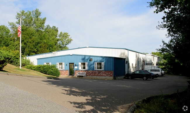
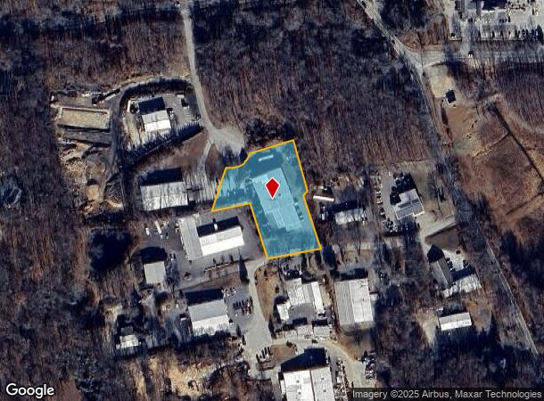
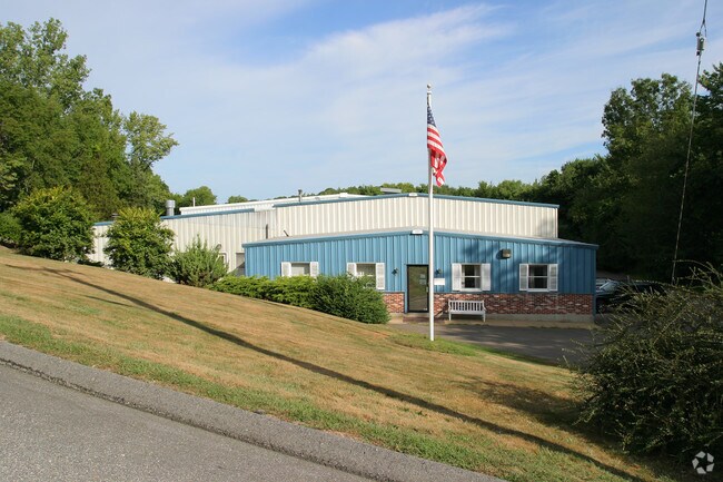
6 Matthews Dr
EHDM-000027M-000000-L000058
Toby Hill Road
Taxexempt
Middlesex
X
Connecticut
09007C0254G
l058
2024
1.82 AC
2025
E Hampton/E Haddam
595101
Hartford
19,970 SF
Hartford-West Hartford-East Hartford, CT
DEMOGRAPHICS near 6 Matthews Dr
1 Mile
3 Mile
5 Mile
2024 Total Population
656
5,411
14,750
2029 Population
656
5,410
14,707
Pop Growth 2024-2029
0.00%
(0.02%)
(0.29%)
Average Age
46
46
46
2024 Total Households
268
2,235
6,152
HH Growth 2024-2029
(0.37%)
(0.18%)
(0.49%)
Median Household Inc
$95,569
$97,206
$103,270
Avg Household Size
2.40
2.30
2.30
2024 Avg HH Vehicles
2.00
2.00
2.00
Median Home Value
$311,290
$301,325
$325,142
Median Year Built
1965
1970
1971
Nearby Places
Map Layers
Map Styles
 Street
 Aerial
- Restaurants
- Banks
- Shops
- Fitness
- Groceries
PUBLIC TRANSPORTATION
AIRPORT
Tweed/New Haven
DRIVE
WALK
Distance
Tweed/New Haven
61 min
39.8 mi
Bradley International
DRIVE
WALK
Distance
Bradley International
69 min
45.7 mi
Freight Ports
Port of New Haven
DRIVE
WALK
Distance
Port of New Haven
58 min
39.5 mi
Nearby Properties
Address
Land Use
TOTAL SIZE
Lot Size
Zoning
Address
Land Use
TOTAL SIZE
Lot Size
Zoning
544.80 AC
R-2
Address
Land Use
TOTAL SIZE
Lot Size
Zoning
12.29 AC
COMM
Address
Land Use
TOTAL SIZE
Lot Size
Zoning
80,962 SF
75.70 AC
R1
Address
Land Use
TOTAL SIZE
Lot Size
Zoning
34,164 SF
2.40 AC
I-1
Address
Land Use
TOTAL SIZE
Lot Size
Zoning
23.16 AC
Address
Land Use
TOTAL SIZE
Lot Size
Zoning
16,008 SF
1.50 AC
C
Address
Land Use
TOTAL SIZE
Lot Size
Zoning
34,239 SF
13.82 AC
R1/2
Address
Land Use
TOTAL SIZE
Lot Size
Zoning
63,485 SF
19 AC
R1
Address
Land Use
TOTAL SIZE
Lot Size
Zoning
19,653 SF
19.89 AC
R2
Address
Land Use
TOTAL SIZE
Lot Size
Zoning
34,574 SF
1.60 AC
COMM
Address
Land Use
TOTAL SIZE
Lot Size
Zoning
880 SF
7.64 AC
EHVD
Address
Land Use
TOTAL SIZE
Lot Size
Zoning
22.26 AC
R-1
Address
Land Use
TOTAL SIZE
Lot Size
Zoning
11.06 AC
R1
Address
Land Use
TOTAL SIZE
Lot Size
Zoning
6.69 AC
R1/2
Address
Land Use
TOTAL SIZE
Lot Size
Zoning
11,472 SF
0.27 AC
EHVD
Address
Land Use
TOTAL SIZE
Lot Size
Zoning
3 AC
COMM
Address
Land Use
TOTAL SIZE
Lot Size
Zoning
6.07 AC
R
Address
Land Use
TOTAL SIZE
Lot Size
Zoning
2.99 AC
IND
Address
Land Use
TOTAL SIZE
Lot Size
Zoning
8,309 SF
2.30 AC
R-2
Address
Land Use
TOTAL SIZE
Lot Size
Zoning
21,905 SF
3.02 AC
C
Address
Land Use
TOTAL SIZE
Lot Size
Zoning
3.20 AC
COMM
Address
Land Use
TOTAL SIZE
Lot Size
Zoning
1,026 SF
46.70 AC
R-2A
Address
Land Use
TOTAL SIZE
Lot Size
Zoning
19.29 AC
C/B/IG
Address
Land Use
TOTAL SIZE
Lot Size
Zoning
5.13 AC
I-1
Address
Land Use
TOTAL SIZE
Lot Size
Zoning
13.52 AC
R-2
Address
Land Use
TOTAL SIZE
Lot Size
Zoning
12,599 SF
0.65 AC
EHVD
Address
Land Use
TOTAL SIZE
Lot Size
Zoning
35.65 AC
R2
Address
Land Use
TOTAL SIZE
Lot Size
Zoning
3.44 AC
R-2
Address
Land Use
TOTAL SIZE
Lot Size
Zoning
87.59 AC
R2
Address
Land Use
TOTAL SIZE
Lot Size
Zoning
2.21 AC
COMM
The World's #1 Commercial Real Estate Marketplace
Connect with us
© 2025 CoStar Group
The information above has been obtained from sources believed reliable. While we do not doubt its accuracy we have not verified it and make no guarantee, warranty or representation about it. It is your responsibility to independently confirm its accuracy and completeness. Any projections, opinions, assumptions, or estimates used are for example only and do not represent the current or future performance of the property. The value of this transaction to you depends on tax and other factors which should be evaluated by your tax, financial, and legal advisors. You and your advisors should conduct a careful, independent investigation of the property to determine to your satisfaction the suitability of the property for your needs.