Property Record
6 Mcintyre Rd, Gibsonia, PA 15044
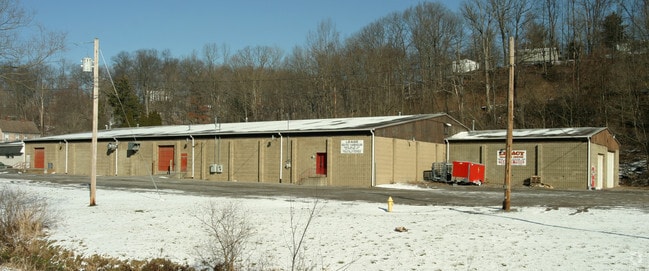

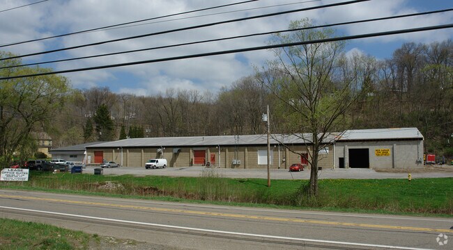
Property Detail
6 Mcintyre Rd
Pittsburgh, PA
V G FREY ROUTE #910 PLAN OF LOTS IRREG LOT #1= 305.93X339.30X104.35 (2.930 A LD) ROUTE #910
1507-L-00331-0000-00
Allegheny
Warehouse
Pennsylvania
A Areas with a 1% annual chance of flooding and a 26% chance of flooding over the life of a 30-year mortgage.
331
2024
2.93 AC
2025
Northeast Pittsburgh
408002
Pittsburgh
NEARBY LISTINGS FOR SALE OR LEASE
DEMOGRAPHICS near 6 Mcintyre Rd
1 mile
3 mile
5 mile
2025 Total Population
6,232
24,239
48,998
2030 Population
6,073
23,762
48,234
Pop Growth 2025-2030
(2.55%)
(1.97%)
(1.56%)
Average Age
44
44
44
2025 Total Households
2,387
9,542
19,094
HH Growth 2025-2030
(2.51%)
(1.97%)
(1.62%)
Median Household Inc
$113,351
$120,172
$116,384
Avg Household Size
2.60
2.50
2.50
2025 Avg HH Vehicles
2.00
2.00
2.00
Median Home Value
$334,659
$349,382
$359,809
Median Year Built
1987
1982
1978
Nearby Places
Map Layers
Map Styles
 Street
 Aerial
Transit
 Traffic
 Biking
Places
Listings with unknown addresses are not visible on the map
- Restaurants
- Banks
- Shops
- Fitness
- Groceries
PUBLIC TRANSPORTATION
AIRPORT
Pittsburgh International
Drive
Walk
Distance
Pittsburgh International
51 min
25.5 mi
Arnold Palmer Regional
Drive
Walk
Distance
Arnold Palmer Regional
68 min
48.1 mi
Nearby Properties
Address
Land Use
TOTAL SIZE
Lot Size
Zoning
Address
Land Use
TOTAL SIZE
Lot Size
Zoning
115.10 AC
Address
Land Use
TOTAL SIZE
Lot Size
Zoning
211.69 AC
Address
Land Use
TOTAL SIZE
Lot Size
Zoning
4,227 SF
23.34 AC
Address
Land Use
TOTAL SIZE
Lot Size
Zoning
28.38 AC
Address
Land Use
TOTAL SIZE
Lot Size
Zoning
Address
Land Use
TOTAL SIZE
Lot Size
Zoning
Address
Land Use
TOTAL SIZE
Lot Size
Zoning
121.54 AC
Address
Land Use
TOTAL SIZE
Lot Size
Zoning
2,616 SF
11.65 AC
Address
Land Use
TOTAL SIZE
Lot Size
Zoning
Address
Land Use
TOTAL SIZE
Lot Size
Zoning
Address
Land Use
TOTAL SIZE
Lot Size
Zoning
Address
Land Use
TOTAL SIZE
Lot Size
Zoning
12.25 AC
Address
Land Use
TOTAL SIZE
Lot Size
Zoning
1,465 SF
11.68 AC
Address
Land Use
TOTAL SIZE
Lot Size
Zoning
13.17 AC
Address
Land Use
TOTAL SIZE
Lot Size
Zoning
1,426 SF
16.11 AC
Address
Land Use
TOTAL SIZE
Lot Size
Zoning
8.23 AC
Address
Land Use
TOTAL SIZE
Lot Size
Zoning
4,434 SF
11.82 AC
Address
Land Use
TOTAL SIZE
Lot Size
Zoning
Address
Land Use
TOTAL SIZE
Lot Size
Zoning
Address
Land Use
TOTAL SIZE
Lot Size
Zoning
6.67 AC
Address
Land Use
TOTAL SIZE
Lot Size
Zoning
14.55 AC
Address
Land Use
TOTAL SIZE
Lot Size
Zoning
41.36 AC
Address
Land Use
TOTAL SIZE
Lot Size
Zoning
21.70 AC
Address
Land Use
TOTAL SIZE
Lot Size
Zoning
Address
Land Use
TOTAL SIZE
Lot Size
Zoning
Address
Land Use
TOTAL SIZE
Lot Size
Zoning
Address
Land Use
TOTAL SIZE
Lot Size
Zoning
8.36 AC
Address
Land Use
TOTAL SIZE
Lot Size
Zoning
Address
Land Use
TOTAL SIZE
Lot Size
Zoning
12.31 AC
Address
Land Use
TOTAL SIZE
Lot Size
Zoning
0.72 AC
The World's #1 Commercial Real Estate Marketplace
Connect with us
© 2026 CoStar Group
The information above has been obtained from sources believed reliable. While we do not doubt its accuracy we have not verified it and make no guarantee, warranty or representation about it. It is your responsibility to independently confirm its accuracy and completeness. Any projections, opinions, assumptions, or estimates used are for example only and do not represent the current or future performance of the property. The value of this transaction to you depends on tax and other factors which should be evaluated by your tax, financial, and legal advisors. You and your advisors should conduct a careful, independent investigation of the property to determine to your satisfaction the suitability of the property for your needs.