Property Record
6 Mckinnon Rd, Bucksport, ME 04416

Save to a Folder
{{folder.Name}}
{{folder.ListingIds.length}} Properties
{{folder.ListingIds.length}} Property
Create a New Folder
Property Detail
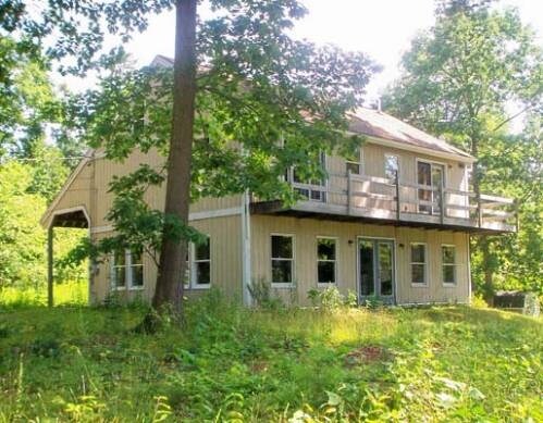
6 Mckinnon Rd
Commercialofficeresidentialmixeduse
Hancock
RT 15
Maine
B and X Area of moderate flood hazard, usually the area between the limits of the 100-year and 500-year floods.
25
2025
2.36 AC
2025
Maine North & Bangor
965300
Other Market Areas
1,872 SF
BUCT-000040-000000-000025
NEARBY LISTINGS FOR SALE OR LEASE
DEMOGRAPHICS near 6 Mckinnon Rd
1 mile
3 mile
5 mile
2025 Total Population
192
3,281
6,539
2030 Population
181
3,138
6,336
Pop Growth 2025-2030
(5.73%)
(4.36%)
(3.10%)
Average Age
43
44
45
2025 Total Households
85
1,441
2,830
HH Growth 2025-2030
(5.88%)
(4.51%)
(3.22%)
Median Household Inc
$68,333
$73,244
$77,786
Avg Household Size
2.20
2.20
2.30
2025 Avg HH Vehicles
1.00
2.00
2.00
Median Home Value
$214,286
$238,043
$257,250
Median Year Built
1973
1972
1975
Nearby Places
Map Layers
Map Styles
 Street
 Aerial
Layers
 Traffic
 Biking
Places
Listings with unknown addresses are not visible on the map
- Restaurants
- Banks
- Shops
- Fitness
- Groceries
PUBLIC TRANSPORTATION
AIRPORT
Bangor International
Drive
Walk
Distance
Bangor International
33 min
19.4 mi
Freight Ports
Searsport, ME
Drive
Walk
Distance
Searsport, ME
21 min
14.6 mi
Nearby Properties
Address
Land Use
TOTAL SIZE
Lot Size
Zoning
Address
Land Use
TOTAL SIZE
Lot Size
Zoning
23.65 AC
VILLAG
Address
Land Use
TOTAL SIZE
Lot Size
Zoning
7.06 AC
INDUST
Address
Land Use
TOTAL SIZE
Lot Size
Zoning
RT 15
Address
Land Use
TOTAL SIZE
Lot Size
Zoning
89.30 AC
Address
Land Use
TOTAL SIZE
Lot Size
Zoning
8.54 AC
VILLAG
Address
Land Use
TOTAL SIZE
Lot Size
Zoning
11.61 AC
VILLAG
Address
Land Use
TOTAL SIZE
Lot Size
Zoning
8.73 AC
Address
Land Use
TOTAL SIZE
Lot Size
Zoning
35.60 AC
Address
Land Use
TOTAL SIZE
Lot Size
Zoning
INDUST
Address
Land Use
TOTAL SIZE
Lot Size
Zoning
3.54 AC
VILLAG
Address
Land Use
TOTAL SIZE
Lot Size
Zoning
INDUST
Address
Land Use
TOTAL SIZE
Lot Size
Zoning
109.20 AC
INDUST
Address
Land Use
TOTAL SIZE
Lot Size
Zoning
2.80 AC
DOWNTO
Address
Land Use
TOTAL SIZE
Lot Size
Zoning
0.86 AC
DOWNTO
Address
Land Use
TOTAL SIZE
Lot Size
Zoning
0.42 AC
VILLAG
Address
Land Use
TOTAL SIZE
Lot Size
Zoning
3.91 AC
Address
Land Use
TOTAL SIZE
Lot Size
Zoning
1.26 AC
COMMER
Address
Land Use
TOTAL SIZE
Lot Size
Zoning
336 SF
63 AC
INDUST
Address
Land Use
TOTAL SIZE
Lot Size
Zoning
1,070 SF
0.50 AC
DOWNTO
Address
Land Use
TOTAL SIZE
Lot Size
Zoning
15,640 SF
0.43 AC
DOWNTO
Address
Land Use
TOTAL SIZE
Lot Size
Zoning
1.94 AC
DOWNTO
Address
Land Use
TOTAL SIZE
Lot Size
Zoning
3.29 AC
VILLAG
Address
Land Use
TOTAL SIZE
Lot Size
Zoning
2.08 AC
COMMER
Address
Land Use
TOTAL SIZE
Lot Size
Zoning
INDUST
Address
Land Use
TOTAL SIZE
Lot Size
Zoning
10.80 AC
Address
Land Use
TOTAL SIZE
Lot Size
Zoning
4,260 SF
1.23 AC
DOWNTO
Address
Land Use
TOTAL SIZE
Lot Size
Zoning
2.67 AC
COMMER
Address
Land Use
TOTAL SIZE
Lot Size
Zoning
0.32 AC
DOWNTO
Address
Land Use
TOTAL SIZE
Lot Size
Zoning
1.08 AC
INDUST
Address
Land Use
TOTAL SIZE
Lot Size
Zoning
1.89 AC
VILLAG
The World's #1 Commercial Real Estate Marketplace
Connect with us
© 2026 CoStar Group
The information above has been obtained from sources believed reliable. While we do not doubt its accuracy we have not verified it and make no guarantee, warranty or representation about it. It is your responsibility to independently confirm its accuracy and completeness. Any projections, opinions, assumptions, or estimates used are for example only and do not represent the current or future performance of the property. The value of this transaction to you depends on tax and other factors which should be evaluated by your tax, financial, and legal advisors. You and your advisors should conduct a careful, independent investigation of the property to determine to your satisfaction the suitability of the property for your needs.