Property Record
6 N Hope Chapel Rd, Jackson, NJ 08527
NEARBY LISTINGS FOR SALE OR LEASE
-
-
View all Jackson listings for lease on LoopNet.com
Property Detail
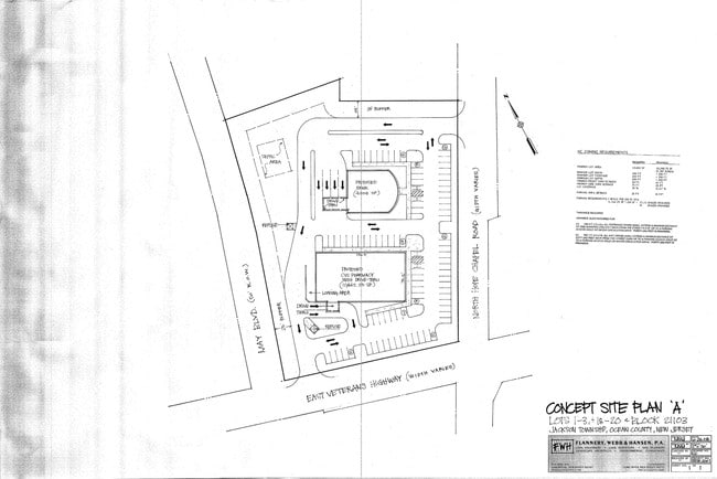
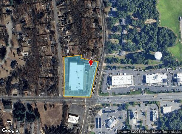
6 N Hope Chapel Rd
New York-Jersey City-White Plains, NY-NJ
Lincoln Park Estates Inc
12-21103-0000-00018
2.633 SELF STORAGE
Commercialnec
Ocean
X
New Jersey
34029C0160F
1.1
2024
2.63 AC
2025
Ocean County
717502
Northern New Jersey
2,496 SF
DEMOGRAPHICS near 6 N Hope Chapel Rd
1 Mile
3 Mile
5 Mile
2024 Total Population
7,354
72,469
179,298
2029 Population
7,608
75,239
185,547
Pop Growth 2024-2029
+ 3.45%
+ 3.82%
+ 3.49%
Average Age
24
29
31
2024 Total Households
1,404
18,091
48,633
HH Growth 2024-2029
+ 2.07%
+ 3.18%
+ 2.73%
Median Household Inc
$82,414
$64,122
$68,894
Avg Household Size
4.60
3.60
3.30
2024 Avg HH Vehicles
2.00
2.00
2.00
Median Home Value
$395,301
$386,148
$364,867
Median Year Built
1996
1990
1989
Nearby Places
Map Layers
Map Styles
 Street
 Aerial
- Restaurants
- Banks
- Shops
- Fitness
- Groceries
SALE & LEASE HISTORY
LISTING DATE
SALE/LEASE

Sep 25, 2016
For Lease
Nearby Properties
Address
Land Use
TOTAL SIZE
Lot Size
Zoning
Address
Land Use
TOTAL SIZE
Lot Size
Zoning
113.02 AC
R12
Address
Land Use
TOTAL SIZE
Lot Size
Zoning
12.43 AC
HD7
Address
Land Use
TOTAL SIZE
Lot Size
Zoning
155.11 AC
PFE/
Address
Land Use
TOTAL SIZE
Lot Size
Zoning
24.15 AC
MF
Address
Land Use
TOTAL SIZE
Lot Size
Zoning
237,479 SF
21 AC
LC
Address
Land Use
TOTAL SIZE
Lot Size
Zoning
21,876 SF
22.26 AC
B3
Address
Land Use
TOTAL SIZE
Lot Size
Zoning
27.47 AC
R1
Address
Land Use
TOTAL SIZE
Lot Size
Zoning
1,032 SF
12.50 AC
HC
Address
Land Use
TOTAL SIZE
Lot Size
Zoning
17,676 SF
7.25 AC
R15
Address
Land Use
TOTAL SIZE
Lot Size
Zoning
98,518 SF
12.71 AC
HC
Address
Land Use
TOTAL SIZE
Lot Size
Zoning
15.17 AC
M1
Address
Land Use
TOTAL SIZE
Lot Size
Zoning
149,442 SF
11.26 AC
NC
Address
Land Use
TOTAL SIZE
Lot Size
Zoning
85,995 SF
7.60 AC
M1
Address
Land Use
TOTAL SIZE
Lot Size
Zoning
8.08 AC
HC
Address
Land Use
TOTAL SIZE
Lot Size
Zoning
1,512 SF
411.32 AC
RD9
Address
Land Use
TOTAL SIZE
Lot Size
Zoning
93,712 SF
15.17 AC
M1
Address
Land Use
TOTAL SIZE
Lot Size
Zoning
1,825 SF
49.38 AC
OSP
Address
Land Use
TOTAL SIZE
Lot Size
Zoning
19.11 AC
M1
Address
Land Use
TOTAL SIZE
Lot Size
Zoning
8.43 AC
MF
Address
Land Use
TOTAL SIZE
Lot Size
Zoning
11.05 AC
PRC
Address
Land Use
TOTAL SIZE
Lot Size
Zoning
1,270 SF
3.65 AC
R12
Address
Land Use
TOTAL SIZE
Lot Size
Zoning
112 SF
20.47 AC
HCMF
Address
Land Use
TOTAL SIZE
Lot Size
Zoning
170,849 SF
12.89 AC
M1
Address
Land Use
TOTAL SIZE
Lot Size
Zoning
24.58 AC
RD
Address
Land Use
TOTAL SIZE
Lot Size
Zoning
127,932 SF
2.41 AC
R-OP
Address
Land Use
TOTAL SIZE
Lot Size
Zoning
3.64 AC
R10
Address
Land Use
TOTAL SIZE
Lot Size
Zoning
96,503 SF
2.26 AC
R-OP
Address
Land Use
TOTAL SIZE
Lot Size
Zoning
26,473 SF
0.72 AC
R-OP
Address
Land Use
TOTAL SIZE
Lot Size
Zoning
164.93 AC
PED+
The World's #1 Commercial Real Estate Marketplace
Connect with us
© 2025 CoStar Group
The information above has been obtained from sources believed reliable. While we do not doubt its accuracy we have not verified it and make no guarantee, warranty or representation about it. It is your responsibility to independently confirm its accuracy and completeness. Any projections, opinions, assumptions, or estimates used are for example only and do not represent the current or future performance of the property. The value of this transaction to you depends on tax and other factors which should be evaluated by your tax, financial, and legal advisors. You and your advisors should conduct a careful, independent investigation of the property to determine to your satisfaction the suitability of the property for your needs.