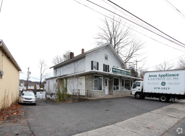
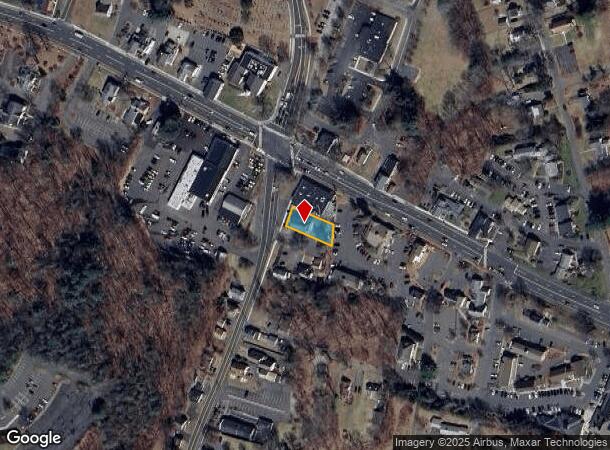
Property Record
6 Old Farms Rd, Avon, CT 06001

NEARBY LISTINGS FOR SALE OR LEASE
Property Detail
6 Old Farms Rd
AVON-000008-000000-000336-000006
Hartford
Commercialbuilding
Connecticut
X
3360006
09003C0337F
0.75 AC
2025
Avon
2025
Hartford
462201
Hartford-West Hartford-East Hartford, CT
DEMOGRAPHICS near 6 Old Farms Rd
1 Mile
3 Mile
5 Mile
2024 Total Population
3,874
19,742
69,430
2029 Population
3,904
19,783
69,413
Pop Growth 2024-2029
+ 0.77%
+ 0.21%
(0.02%)
Average Age
45
43
43
2024 Total Households
1,698
7,701
27,684
HH Growth 2024-2029
+ 0.77%
+ 0.23%
(0.07%)
Median Household Inc
$112,674
$135,644
$131,365
Avg Household Size
2.20
2.50
2.40
2024 Avg HH Vehicles
2.00
2.00
2.00
Median Home Value
$412,849
$395,136
$391,114
Median Year Built
1978
1976
1973
Nearby Places
Map Layers
Map Styles
 Street
 Aerial
- Restaurants
- Banks
- Shops
- Fitness
- Groceries
PUBLIC TRANSPORTATION
COMMUTER RAIL
Hartford (Hartford Line - Hartford Line)
DRIVE
WALK
Distance
Hartford (Hartford Line - Hartford Line)
12 min
9.2 mi
Hartford Amtrak Station (Amtrak Hartford Line - Amtrak, Northeast Regional - Amtrak, Valley Flyer - Amtrak, Vermonter - Amtrak)
DRIVE
WALK
Distance
Hartford Amtrak Station (Amtrak Hartford Line - Amtrak, Northeast Regional - Amtrak, Valley Flyer - Amtrak, Vermonter - Amtrak)
12 min
9.4 mi
AIRPORT
Bradley International
DRIVE
WALK
Distance
Bradley International
36 min
16.7 mi
Freight Ports
Port of New Haven
DRIVE
WALK
Distance
Port of New Haven
53 min
39.9 mi
Nearby Properties
Address
Land Use
TOTAL SIZE
Lot Size
Zoning
Address
Land Use
TOTAL SIZE
Lot Size
Zoning
39.86 AC
R40
Address
Land Use
TOTAL SIZE
Lot Size
Zoning
234.01 AC
EL
Address
Land Use
TOTAL SIZE
Lot Size
Zoning
35.44 AC
HSFBC
Address
Land Use
TOTAL SIZE
Lot Size
Zoning
124 AC
B
Address
Land Use
TOTAL SIZE
Lot Size
Zoning
26,928 SF
14.77 AC
PAD
Address
Land Use
TOTAL SIZE
Lot Size
Zoning
39,281 SF
678.81 AC
R-80
Address
Land Use
TOTAL SIZE
Lot Size
Zoning
14.77 AC
R-40
Address
Land Use
TOTAL SIZE
Lot Size
Zoning
16.40 AC
B-3
Address
Land Use
TOTAL SIZE
Lot Size
Zoning
49,881 SF
18 AC
R-40
Address
Land Use
TOTAL SIZE
Lot Size
Zoning
18.52 AC
R40
Address
Land Use
TOTAL SIZE
Lot Size
Zoning
21.24 AC
R40
Address
Land Use
TOTAL SIZE
Lot Size
Zoning
5,640 SF
106.10 AC
R-40
Address
Land Use
TOTAL SIZE
Lot Size
Zoning
46.60 AC
RU2A
Address
Land Use
TOTAL SIZE
Lot Size
Zoning
121,561 SF
4.56 AC
HSFBC
Address
Land Use
TOTAL SIZE
Lot Size
Zoning
21.86 AC
Address
Land Use
TOTAL SIZE
Lot Size
Zoning
18.05 AC
CR
Address
Land Use
TOTAL SIZE
Lot Size
Zoning
10.91 AC
AVC
Address
Land Use
TOTAL SIZE
Lot Size
Zoning
13.08 AC
CR
Address
Land Use
TOTAL SIZE
Lot Size
Zoning
21.06 AC
B-3
Address
Land Use
TOTAL SIZE
Lot Size
Zoning
64,974 SF
B
Address
Land Use
TOTAL SIZE
Lot Size
Zoning
5.12 AC
Address
Land Use
TOTAL SIZE
Lot Size
Zoning
10 AC
RU2A
Address
Land Use
TOTAL SIZE
Lot Size
Zoning
6.57 AC
IP
Address
Land Use
TOTAL SIZE
Lot Size
Zoning
64,948 SF
9 AC
B-3
Address
Land Use
TOTAL SIZE
Lot Size
Zoning
20.11 AC
Address
Land Use
TOTAL SIZE
Lot Size
Zoning
4.02 AC
CP-A
Address
Land Use
TOTAL SIZE
Lot Size
Zoning
3.80 AC
Address
Land Use
TOTAL SIZE
Lot Size
Zoning
15.90 AC
R40
Address
Land Use
TOTAL SIZE
Lot Size
Zoning
19.72 AC
RD
Address
Land Use
TOTAL SIZE
Lot Size
Zoning
8.73 AC
The World's #1 Commercial Real Estate Marketplace
Connect with us
© 2025 CoStar Group
The information above has been obtained from sources believed reliable. While we do not doubt its accuracy we have not verified it and make no guarantee, warranty or representation about it. It is your responsibility to independently confirm its accuracy and completeness. Any projections, opinions, assumptions, or estimates used are for example only and do not represent the current or future performance of the property. The value of this transaction to you depends on tax and other factors which should be evaluated by your tax, financial, and legal advisors. You and your advisors should conduct a careful, independent investigation of the property to determine to your satisfaction the suitability of the property for your needs.