Property Record
6 River Rd, Summit, NJ 07901
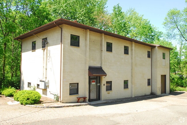


Property Detail
6 River Rd
18-00201-0000-00012
Union
Servicestation
New Jersey
LI
12
AE The base floodplain where base flood elevations are provided. AE Zones are now used on new format FIRMs instead of A1-A30 Zones.
1.99 AC
2024
Short Hills/Millburn
2025
Northern New Jersey
037700
Newark, NJ
1,596 SF
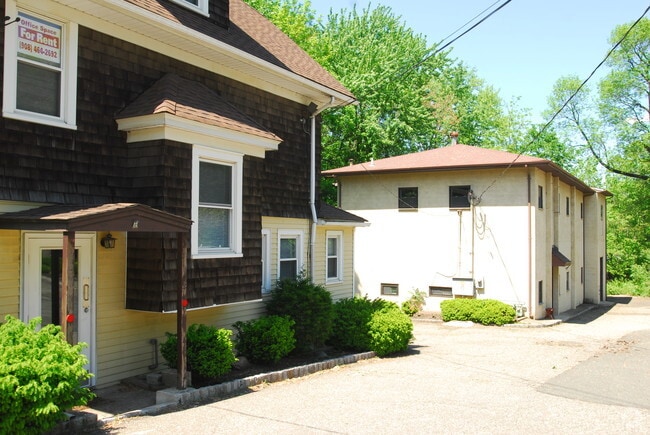
NEARBY LISTINGS FOR SALE OR LEASE
DEMOGRAPHICS near 6 River Rd
1 mile
3 mile
5 mile
2024 Total Population
12,162
81,886
197,226
2029 Population
12,706
85,720
207,349
Pop Growth 2024-2029
+ 4.47%
+ 4.68%
+ 5.13%
Average Age
40
40
41
2024 Total Households
4,224
28,583
68,908
HH Growth 2024-2029
+ 4.55%
+ 4.72%
+ 5.16%
Median Household Inc
$216,862
$202,283
$187,732
Avg Household Size
2.80
2.80
2.80
2024 Avg HH Vehicles
2.00
2.00
2.00
Median Home Value
$931,323
$952,375
$842,606
Median Year Built
1953
1958
1960
Nearby Places
Map Layers
Map Styles
 Street
 Aerial
Transit
 Traffic
 Biking
Places
Listings with unknown addresses are not visible on the map
- Restaurants
- Banks
- Shops
- Fitness
- Groceries
PUBLIC TRANSPORTATION
COMMUTER RAIL
Chatham (Morris & Essex Morristown Line - NJ Transit Commuter Rail (NJ Transit))
Drive
Walk
Distance
Chatham (Morris & Essex Morristown Line - NJ Transit Commuter Rail (NJ Transit))
3 min
1.1 mi
New Providence (Morris & Essex Gladstone Branch - NJ Transit Commuter Rail (NJ Transit))
Drive
Walk
Distance
New Providence (Morris & Essex Gladstone Branch - NJ Transit Commuter Rail (NJ Transit))
4 min
1.6 mi
AIRPORT
Newark Liberty International
Drive
Walk
Distance
Newark Liberty International
20 min
14.7 mi
LaGuardia
Drive
Walk
Distance
LaGuardia
54 min
33.9 mi
John F Kennedy International
Drive
Walk
Distance
John F Kennedy International
63 min
42.1 mi
Freight Ports
Maher Terminal
Drive
Walk
Distance
Maher Terminal
24 min
15.3 mi
Nearby Properties
Address
Land Use
TOTAL SIZE
Lot Size
Zoning
Address
Land Use
TOTAL SIZE
Lot Size
Zoning
46.18 AC
Address
Land Use
TOTAL SIZE
Lot Size
Zoning
1,968 SF
88.85 AC
PROD
Address
Land Use
TOTAL SIZE
Lot Size
Zoning
Address
Land Use
TOTAL SIZE
Lot Size
Zoning
64.30 AC
MF-4
Address
Land Use
TOTAL SIZE
Lot Size
Zoning
4,595 SF
4.57 AC
M-3
Address
Land Use
TOTAL SIZE
Lot Size
Zoning
7.19 AC
PI
Address
Land Use
TOTAL SIZE
Lot Size
Zoning
4.30 AC
OR-3
Address
Land Use
TOTAL SIZE
Lot Size
Zoning
19.05 AC
R-2
Address
Land Use
TOTAL SIZE
Lot Size
Zoning
Address
Land Use
TOTAL SIZE
Lot Size
Zoning
296,578 SF
15 AC
Address
Land Use
TOTAL SIZE
Lot Size
Zoning
Address
Land Use
TOTAL SIZE
Lot Size
Zoning
Address
Land Use
TOTAL SIZE
Lot Size
Zoning
7.52 AC
OR-3
Address
Land Use
TOTAL SIZE
Lot Size
Zoning
2,806 SF
22.79 AC
Address
Land Use
TOTAL SIZE
Lot Size
Zoning
144.37 AC
Address
Land Use
TOTAL SIZE
Lot Size
Zoning
8.32 AC
Address
Land Use
TOTAL SIZE
Lot Size
Zoning
40.90 AC
MF-4
Address
Land Use
TOTAL SIZE
Lot Size
Zoning
9.44 AC
Address
Land Use
TOTAL SIZE
Lot Size
Zoning
22,488 SF
7.67 AC
Address
Land Use
TOTAL SIZE
Lot Size
Zoning
19.14 AC
Address
Land Use
TOTAL SIZE
Lot Size
Zoning
24.60 AC
R-L
Address
Land Use
TOTAL SIZE
Lot Size
Zoning
128.98 AC
Address
Land Use
TOTAL SIZE
Lot Size
Zoning
28.09 AC
R-3
Address
Land Use
TOTAL SIZE
Lot Size
Zoning
51,610 SF
12.32 AC
R-1
Address
Land Use
TOTAL SIZE
Lot Size
Zoning
104,400 SF
12.86 AC
L-1
Address
Land Use
TOTAL SIZE
Lot Size
Zoning
10.14 AC
R-2
Address
Land Use
TOTAL SIZE
Lot Size
Zoning
35.72 AC
PROD
Address
Land Use
TOTAL SIZE
Lot Size
Zoning
4.04 AC
B
Address
Land Use
TOTAL SIZE
Lot Size
Zoning
13,458 SF
33.40 AC
R-2
Address
Land Use
TOTAL SIZE
Lot Size
Zoning
12.90 AC
The World's #1 Commercial Real Estate Marketplace
Connect with us
© 2026 CoStar Group
The information above has been obtained from sources believed reliable. While we do not doubt its accuracy we have not verified it and make no guarantee, warranty or representation about it. It is your responsibility to independently confirm its accuracy and completeness. Any projections, opinions, assumptions, or estimates used are for example only and do not represent the current or future performance of the property. The value of this transaction to you depends on tax and other factors which should be evaluated by your tax, financial, and legal advisors. You and your advisors should conduct a careful, independent investigation of the property to determine to your satisfaction the suitability of the property for your needs.