Property Record
6 Smith Ln, Londonderry, NH 03053
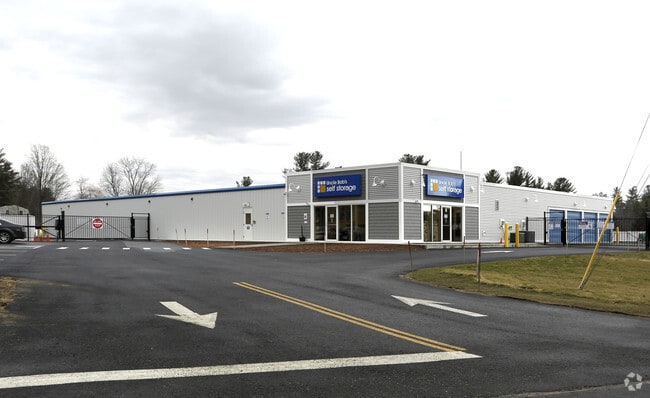

Property Detail
6 Smith Ln
LOND-000015-000000-000128
ROCKINGHAM
Commercialnec
New Hampshire
C-II
128-0
B and X Area of moderate flood hazard, usually the area between the limits of the 100-year and 500-year floods.
5.69 AC
2025
Rockingham
2025
Boston
003703
Boston-Cambridge-Newton, MA-NH
NEARBY LISTINGS FOR SALE OR LEASE
-
-
View all Londonderry listings for sale on LoopNet.com
DEMOGRAPHICS near 6 Smith Ln
1 mile
3 mile
5 mile
2025 Total Population
2,468
19,911
76,270
2030 Population
2,568
20,411
77,372
Pop Growth 2025-2030
+ 4.05%
+ 2.51%
+ 1.44%
Average Age
42
41
42
2025 Total Households
973
7,451
30,393
HH Growth 2025-2030
+ 4.01%
+ 2.59%
+ 1.41%
Median Household Inc
$125,549
$122,426
$104,443
Avg Household Size
2.50
2.60
2.40
2025 Avg HH Vehicles
2.00
2.00
2.00
Median Home Value
$608,786
$473,335
$420,782
Median Year Built
1997
1989
1981
Nearby Places
Map Layers
Map Styles
 Street
 Aerial
Layers
 Traffic
 Biking
Places
Listings with unknown addresses are not visible on the map
- Restaurants
- Banks
- Shops
- Fitness
- Groceries
PUBLIC TRANSPORTATION
AIRPORT
Manchester Boston Regional
Drive
Walk
Distance
Manchester Boston Regional
14 min
5.5 mi
Freight Ports
Port of Boston
Drive
Walk
Distance
Port of Boston
75 min
49.1 mi
SALE & LEASE HISTORY
LISTING DATE
SALE/LEASE

May 03, 2017
For Sale
Nearby Properties
Address
Land Use
TOTAL SIZE
Lot Size
Zoning
Address
Land Use
TOTAL SIZE
Lot Size
Zoning
768,020 SF
74.47 AC
I-II
Address
Land Use
TOTAL SIZE
Lot Size
Zoning
603,357 SF
45.12 AC
GB
Address
Land Use
TOTAL SIZE
Lot Size
Zoning
8,064 SF
34.29 AC
Address
Land Use
TOTAL SIZE
Lot Size
Zoning
1,710 SF
65 AC
AR-I
Address
Land Use
TOTAL SIZE
Lot Size
Zoning
50.47 AC
GB
Address
Land Use
TOTAL SIZE
Lot Size
Zoning
723,875 SF
38.08 AC
Address
Land Use
TOTAL SIZE
Lot Size
Zoning
180,600 SF
14.19 AC
IND-I
Address
Land Use
TOTAL SIZE
Lot Size
Zoning
366,008 SF
41.69 AC
IND-I
Address
Land Use
TOTAL SIZE
Lot Size
Zoning
487,970 SF
79.74 AC
IND-I
Address
Land Use
TOTAL SIZE
Lot Size
Zoning
201,831 SF
18.46 AC
IND-II
Address
Land Use
TOTAL SIZE
Lot Size
Zoning
119,139 SF
25.87 AC
IND-I
Address
Land Use
TOTAL SIZE
Lot Size
Zoning
142,318 SF
26.13 AC
GB
Address
Land Use
TOTAL SIZE
Lot Size
Zoning
227,589 SF
GB
Address
Land Use
TOTAL SIZE
Lot Size
Zoning
244,637 SF
27.28 AC
IND-II
Address
Land Use
TOTAL SIZE
Lot Size
Zoning
304,312 SF
29.62 AC
IND-II
Address
Land Use
TOTAL SIZE
Lot Size
Zoning
117,412 SF
12.86 AC
C-II
Address
Land Use
TOTAL SIZE
Lot Size
Zoning
33.45 AC
IND4
Address
Land Use
TOTAL SIZE
Lot Size
Zoning
116.34 AC
IND-II
Address
Land Use
TOTAL SIZE
Lot Size
Zoning
90,406 SF
24.78 AC
AR-I
Address
Land Use
TOTAL SIZE
Lot Size
Zoning
24.20 AC
GB
Address
Land Use
TOTAL SIZE
Lot Size
Zoning
125,060 SF
8.76 AC
IND-I
Address
Land Use
TOTAL SIZE
Lot Size
Zoning
48,392 SF
8.32 AC
GB
Address
Land Use
TOTAL SIZE
Lot Size
Zoning
722 SF
65 AC
Address
Land Use
TOTAL SIZE
Lot Size
Zoning
100,800 SF
17.81 AC
4
Address
Land Use
TOTAL SIZE
Lot Size
Zoning
113,420 SF
7.31 AC
Address
Land Use
TOTAL SIZE
Lot Size
Zoning
71,810 SF
12.37 AC
Address
Land Use
TOTAL SIZE
Lot Size
Zoning
13.67 AC
R-III
Address
Land Use
TOTAL SIZE
Lot Size
Zoning
143,060 SF
10.04 AC
Address
Land Use
TOTAL SIZE
Lot Size
Zoning
60,246 SF
3 AC
Address
Land Use
TOTAL SIZE
Lot Size
Zoning
111,448 SF
7.35 AC
The World's #1 Commercial Real Estate Marketplace
Connect with us
© 2026 CoStar Group
The information above has been obtained from sources believed reliable. While we do not doubt its accuracy we have not verified it and make no guarantee, warranty or representation about it. It is your responsibility to independently confirm its accuracy and completeness. Any projections, opinions, assumptions, or estimates used are for example only and do not represent the current or future performance of the property. The value of this transaction to you depends on tax and other factors which should be evaluated by your tax, financial, and legal advisors. You and your advisors should conduct a careful, independent investigation of the property to determine to your satisfaction the suitability of the property for your needs.