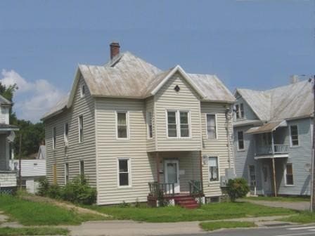
Property Record
6 Spaulding Ave, Malone, NY 12953
NEARBY LISTINGS FOR SALE OR LEASE
-
-
View all Malone listings for sale on LoopNet.com
Property Detail
6 Spaulding Ave
Malone, NY
SECB BLOCK214 LOT11
164801-112-026-0001-038-000-0000
Franklin
Apartment
New York
2025
40.000
2024
0.11 AC
951400
Other Market Areas
3,162 SF
DEMOGRAPHICS near 6 Spaulding Ave
1 Mile
3 Mile
5 Mile
2024 Total Population
5,694
9,438
11,807
2029 Population
5,730
9,468
11,835
Pop Growth 2024-2029
+ 0.63%
+ 0.32%
+ 0.24%
Average Age
41
41
41
2024 Total Households
2,493
3,449
4,245
HH Growth 2024-2029
+ 0.56%
+ 0.49%
+ 0.40%
Median Household Inc
$49,999
$56,281
$58,727
Avg Household Size
2.10
2.20
2.20
2024 Avg HH Vehicles
1.00
1.00
2.00
Median Home Value
$109,470
$115,919
$122,851
Median Year Built
1952
1959
1962
Nearby Places
- Restaurants
- Banks
- Shops
- Fitness
- Groceries
Nearby Properties
Address
Land Use
TOTAL SIZE
Lot Size
Zoning
Address
Land Use
TOTAL SIZE
Lot Size
Zoning
5,000 SF
39 AC
01 - NOT Z
Address
Land Use
TOTAL SIZE
Lot Size
Zoning
72,732 SF
11 AC
01 - NOT Z
Address
Land Use
TOTAL SIZE
Lot Size
Zoning
141,000 SF
203.61 AC
01 - NOT Z
Address
Land Use
TOTAL SIZE
Lot Size
Zoning
141,000 SF
191.46 AC
01 - NOT Z
Address
Land Use
TOTAL SIZE
Lot Size
Zoning
6,600 SF
32.83 AC
01 - NOT Z
Address
Land Use
TOTAL SIZE
Lot Size
Zoning
196,710 SF
25.15 AC
01 - NOT Z
Address
Land Use
TOTAL SIZE
Lot Size
Zoning
51,438 SF
4.90 AC
01 - NOT Z
Address
Land Use
TOTAL SIZE
Lot Size
Zoning
84,758 SF
4.21 AC
01 - NOT Z
Address
Land Use
TOTAL SIZE
Lot Size
Zoning
49,944 SF
3.02 AC
01 - NOT Z
Address
Land Use
TOTAL SIZE
Lot Size
Zoning
62,013 SF
4.91 AC
01 - NOT Z
Address
Land Use
TOTAL SIZE
Lot Size
Zoning
67,465 SF
14.48 AC
01 - NOT Z
Address
Land Use
TOTAL SIZE
Lot Size
Zoning
0.01 AC
Address
Land Use
TOTAL SIZE
Lot Size
Zoning
Address
Land Use
TOTAL SIZE
Lot Size
Zoning
37,997 SF
8.70 AC
01 - NOT Z
Address
Land Use
TOTAL SIZE
Lot Size
Zoning
29,872 SF
9.67 AC
01 - NOT Z
Address
Land Use
TOTAL SIZE
Lot Size
Zoning
40,420 SF
10 AC
01 - NOT Z
Address
Land Use
TOTAL SIZE
Lot Size
Zoning
Address
Land Use
TOTAL SIZE
Lot Size
Zoning
50,127 SF
3.13 AC
01 - NOT Z
Address
Land Use
TOTAL SIZE
Lot Size
Zoning
5,910 SF
22.16 AC
01 - NOT Z
Address
Land Use
TOTAL SIZE
Lot Size
Zoning
11.13 AC
Address
Land Use
TOTAL SIZE
Lot Size
Zoning
34,548 SF
5.16 AC
01 - NOT Z
Address
Land Use
TOTAL SIZE
Lot Size
Zoning
41,638 SF
5.83 AC
01 - NOT Z
Address
Land Use
TOTAL SIZE
Lot Size
Zoning
2,157 SF
4.95 AC
01 - NOT Z
Address
Land Use
TOTAL SIZE
Lot Size
Zoning
Address
Land Use
TOTAL SIZE
Lot Size
Zoning
14,735 SF
1.67 AC
01 - NOT Z
Address
Land Use
TOTAL SIZE
Lot Size
Zoning
22,036 SF
3.15 AC
01 - NOT Z
Address
Land Use
TOTAL SIZE
Lot Size
Zoning
45,410 SF
3.67 AC
01 - NOT Z
Address
Land Use
TOTAL SIZE
Lot Size
Zoning
11.13 AC
01 - NOT Z
Address
Land Use
TOTAL SIZE
Lot Size
Zoning
15,878 SF
73.60 AC
01 - NOT Z
Address
Land Use
TOTAL SIZE
Lot Size
Zoning
16,594 SF
7.09 AC
01 - NOT Z
The World's #1 Commercial Real Estate Marketplace
Connect with us
© 2025 CoStar Group
The information above has been obtained from sources believed reliable. While we do not doubt its accuracy we have not verified it and make no guarantee, warranty or representation about it. It is your responsibility to independently confirm its accuracy and completeness. Any projections, opinions, assumptions, or estimates used are for example only and do not represent the current or future performance of the property. The value of this transaction to you depends on tax and other factors which should be evaluated by your tax, financial, and legal advisors. You and your advisors should conduct a careful, independent investigation of the property to determine to your satisfaction the suitability of the property for your needs.