Property Record
6 Sycamore Way, Branford, CT 06405
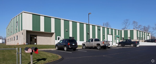

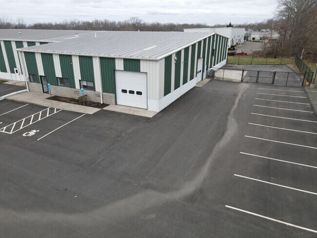
Property Detail
6 Sycamore Way
BRAN-000004J-000002-000003-000007
South Central Ct
Industrialgeneral
Connecticut
B and X Area of moderate flood hazard, usually the area between the limits of the 100-year and 500-year floods.
3.7
2025
1.78 AC
2025
Branford
184700
Westchester/So Connecticut
20,260 SF
New Haven, CT
NEARBY LISTINGS FOR SALE OR LEASE
DEMOGRAPHICS near 6 Sycamore Way
1 mile
3 mile
5 mile
2025 Total Population
1,081
19,206
56,294
2030 Population
1,111
19,625
57,512
Pop Growth 2025-2030
+ 2.78%
+ 2.18%
+ 2.16%
Average Age
47
47
46
2025 Total Households
455
8,156
24,296
HH Growth 2025-2030
+ 2.64%
+ 2.12%
+ 2.15%
Median Household Inc
$117,592
$124,769
$105,847
Avg Household Size
2.30
2.30
2.30
2025 Avg HH Vehicles
2.00
2.00
2.00
Median Home Value
$460,118
$465,500
$446,252
Median Year Built
1980
1974
1972
Nearby Places
Map Layers
Map Styles
 Street
 Aerial
Layers
 Traffic
 Biking
Places
Listings with unknown addresses are not visible on the map
- Restaurants
- Banks
- Shops
- Fitness
- Groceries
PUBLIC TRANSPORTATION
COMMUTER RAIL
Branford (Shore Line East - Shore Line East)
Drive
Walk
Distance
Branford (Shore Line East - Shore Line East)
10 min
4.4 mi
Drive
Walk
Distance
12 min
6.2 mi
AIRPORT
Tweed/New Haven
Drive
Walk
Distance
Tweed/New Haven
15 min
8.2 mi
SALE & LEASE HISTORY
LISTING DATE
SALE/LEASE

Oct 18, 2023
For Lease
Aug 26, 2024
For Lease
Nearby Properties
Address
Land Use
TOTAL SIZE
Lot Size
Zoning
Address
Land Use
TOTAL SIZE
Lot Size
Zoning
30 AC
R-5
Address
Land Use
TOTAL SIZE
Lot Size
Zoning
227,335 SF
38.50 AC
Address
Land Use
TOTAL SIZE
Lot Size
Zoning
88.66 AC
I3
Address
Land Use
TOTAL SIZE
Lot Size
Zoning
175,913 SF
29 AC
Address
Land Use
TOTAL SIZE
Lot Size
Zoning
2,295.68 AC
R80
Address
Land Use
TOTAL SIZE
Lot Size
Zoning
7,065 SF
9.44 AC
Address
Land Use
TOTAL SIZE
Lot Size
Zoning
27.83 AC
SC
Address
Land Use
TOTAL SIZE
Lot Size
Zoning
10.30 AC
B1
Address
Land Use
TOTAL SIZE
Lot Size
Zoning
8.29 AC
Address
Land Use
TOTAL SIZE
Lot Size
Zoning
142,136 SF
58.31 AC
R-8
Address
Land Use
TOTAL SIZE
Lot Size
Zoning
2,196 SF
1.68 AC
PRB3
Address
Land Use
TOTAL SIZE
Lot Size
Zoning
Address
Land Use
TOTAL SIZE
Lot Size
Zoning
13.90 AC
Address
Land Use
TOTAL SIZE
Lot Size
Zoning
54,799 SF
4.06 AC
Address
Land Use
TOTAL SIZE
Lot Size
Zoning
15.10 AC
Address
Land Use
TOTAL SIZE
Lot Size
Zoning
7.69 AC
RU1
Address
Land Use
TOTAL SIZE
Lot Size
Zoning
29.40 AC
Address
Land Use
TOTAL SIZE
Lot Size
Zoning
5,440 SF
12.44 AC
RGA
Address
Land Use
TOTAL SIZE
Lot Size
Zoning
49,215 SF
2.09 AC
Address
Land Use
TOTAL SIZE
Lot Size
Zoning
40,164 SF
11.50 AC
Address
Land Use
TOTAL SIZE
Lot Size
Zoning
45,766 SF
7.71 AC
R-7
Address
Land Use
TOTAL SIZE
Lot Size
Zoning
58,910 SF
5.17 AC
Address
Land Use
TOTAL SIZE
Lot Size
Zoning
38,352 SF
24 AC
Address
Land Use
TOTAL SIZE
Lot Size
Zoning
86,508 SF
7.07 AC
Address
Land Use
TOTAL SIZE
Lot Size
Zoning
58,601 SF
3.29 AC
Address
Land Use
TOTAL SIZE
Lot Size
Zoning
35,132 SF
2.89 AC
Address
Land Use
TOTAL SIZE
Lot Size
Zoning
Address
Land Use
TOTAL SIZE
Lot Size
Zoning
36,856 SF
3.10 AC
Address
Land Use
TOTAL SIZE
Lot Size
Zoning
Address
Land Use
TOTAL SIZE
Lot Size
Zoning
52,518 SF
3.52 AC
The World's #1 Commercial Real Estate Marketplace
Connect with us
© 2026 CoStar Group
The information above has been obtained from sources believed reliable. While we do not doubt its accuracy we have not verified it and make no guarantee, warranty or representation about it. It is your responsibility to independently confirm its accuracy and completeness. Any projections, opinions, assumptions, or estimates used are for example only and do not represent the current or future performance of the property. The value of this transaction to you depends on tax and other factors which should be evaluated by your tax, financial, and legal advisors. You and your advisors should conduct a careful, independent investigation of the property to determine to your satisfaction the suitability of the property for your needs.