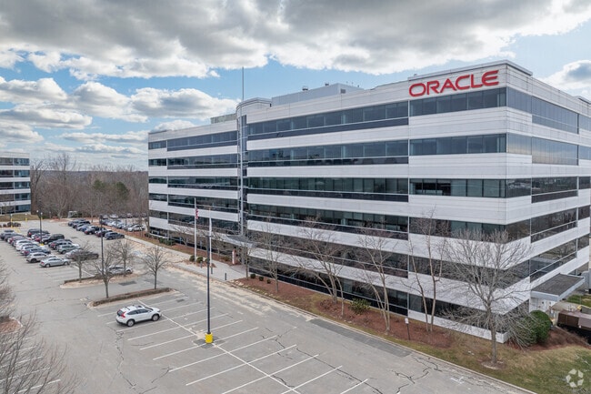
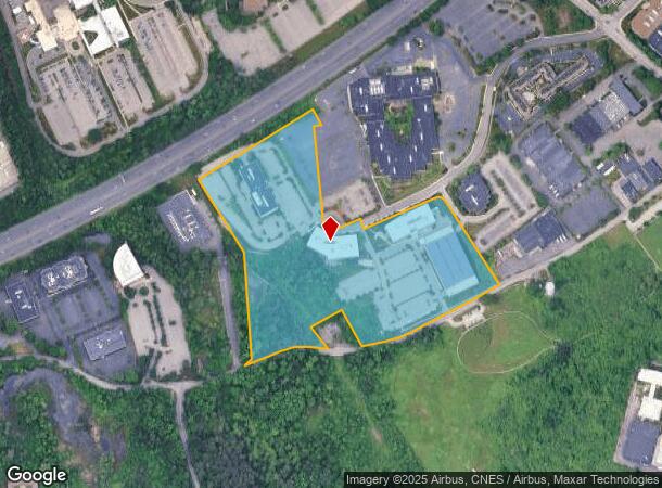
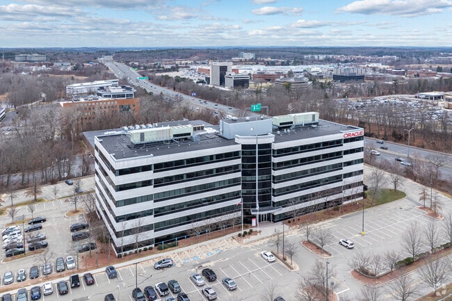
Property Record
10 Van De Graaff Dr, Burlington, MA 01803
Current Lease Availabilities
NEARBY LISTINGS FOR SALE OR LEASE
Property Detail
10 Van De Graaff Dr
BURL-000053-000000-000007-000001
Middlesex
Commercialnec
Massachusetts
X
23.91 AC
25017C0402F
Burlington/Woburn
2023
Boston
2025
Boston-Cambridge-Newton, MA-NH
332402
DEMOGRAPHICS near 10 Van De Graaff Dr
1 mile
3 mile
5 mile
2024 Total Population
4,354
74,825
196,024
2029 Population
4,312
74,338
194,574
Pop Growth 2024-2029
(0.96%)
(0.65%)
(0.74%)
Average Age
44
42
42
2024 Total Households
1,711
28,274
73,189
HH Growth 2024-2029
(1.11%)
(0.72%)
(0.81%)
Median Household Inc
$120,404
$128,556
$140,718
Avg Household Size
2.50
2.60
2.60
2024 Avg HH Vehicles
2.00
2.00
2.00
Median Home Value
$723,548
$781,484
$789,468
Median Year Built
1985
1969
1964
Nearby Places
Map Layers
Map Styles
 Street
 Aerial
Transit
 Traffic
 Biking
Places
Listings with unknown addresses are not visible on the map
- Restaurants
- Banks
- Shops
- Fitness
- Groceries
PUBLIC TRANSPORTATION
COMMUTER RAIL
Wedgemere (Lowell Line - Massachusetts Bay Transportation Authority Commuter Rail (Purple Line))
Drive
Walk
Distance
Wedgemere (Lowell Line - Massachusetts Bay Transportation Authority Commuter Rail (Purple Line))
9 min
5.0 mi
Winchester Center (Lowell Line - Massachusetts Bay Transportation Authority Commuter Rail (Purple Line))
Drive
Walk
Distance
Winchester Center (Lowell Line - Massachusetts Bay Transportation Authority Commuter Rail (Purple Line))
8 min
5.1 mi
AIRPORT
General Edward Lawrence Logan International
Drive
Walk
Distance
General Edward Lawrence Logan International
28 min
15.0 mi
Manchester Boston Regional
Drive
Walk
Distance
Manchester Boston Regional
63 min
42.2 mi
Nearby Properties
Address
Land Use
TOTAL SIZE
Lot Size
Zoning
Address
Land Use
TOTAL SIZE
Lot Size
Zoning
72,799 SF
69.22 AC
IND
Address
Land Use
TOTAL SIZE
Lot Size
Zoning
169 AC
OS
Address
Land Use
TOTAL SIZE
Lot Size
Zoning
135,300 SF
30.85 AC
PD
Address
Land Use
TOTAL SIZE
Lot Size
Zoning
35.90 AC
5
Address
Land Use
TOTAL SIZE
Lot Size
Zoning
388,978 SF
23.23 AC
RG
Address
Land Use
TOTAL SIZE
Lot Size
Zoning
27.56 AC
R-2
Address
Land Use
TOTAL SIZE
Lot Size
Zoning
37.77 AC
PD
Address
Land Use
TOTAL SIZE
Lot Size
Zoning
15.95 AC
BG
Address
Land Use
TOTAL SIZE
Lot Size
Zoning
405,606 SF
33.40 AC
RO
Address
Land Use
TOTAL SIZE
Lot Size
Zoning
18.62 AC
O-P
Address
Land Use
TOTAL SIZE
Lot Size
Zoning
346,106 SF
42.04 AC
RO
Address
Land Use
TOTAL SIZE
Lot Size
Zoning
330,500 SF
7.44 AC
PD
Address
Land Use
TOTAL SIZE
Lot Size
Zoning
32.07 AC
PD
Address
Land Use
TOTAL SIZE
Lot Size
Zoning
262,278 SF
3.80 AC
PD
Address
Land Use
TOTAL SIZE
Lot Size
Zoning
325,799 SF
21.70 AC
IND
Address
Land Use
TOTAL SIZE
Lot Size
Zoning
292,150 SF
17.76 AC
Address
Land Use
TOTAL SIZE
Lot Size
Zoning
12.02 AC
IG
Address
Land Use
TOTAL SIZE
Lot Size
Zoning
281,240 SF
15 AC
IG
Address
Land Use
TOTAL SIZE
Lot Size
Zoning
30.92 AC
RO
Address
Land Use
TOTAL SIZE
Lot Size
Zoning
11.70 AC
BG
Address
Land Use
TOTAL SIZE
Lot Size
Zoning
265,827 SF
10.38 AC
IH
Address
Land Use
TOTAL SIZE
Lot Size
Zoning
25.50 AC
BG
Address
Land Use
TOTAL SIZE
Lot Size
Zoning
6.69 AC
PD
Address
Land Use
TOTAL SIZE
Lot Size
Zoning
186,516 SF
40 AC
R-1
Address
Land Use
TOTAL SIZE
Lot Size
Zoning
7.90 AC
PD
Address
Land Use
TOTAL SIZE
Lot Size
Zoning
14.82 AC
RO
Address
Land Use
TOTAL SIZE
Lot Size
Zoning
9.82 AC
PD
Address
Land Use
TOTAL SIZE
Lot Size
Zoning
216,224 SF
5.71 AC
NPD
The World's #1 Commercial Real Estate Marketplace
Connect with us
© 2026 CoStar Group
The information above has been obtained from sources believed reliable. While we do not doubt its accuracy we have not verified it and make no guarantee, warranty or representation about it. It is your responsibility to independently confirm its accuracy and completeness. Any projections, opinions, assumptions, or estimates used are for example only and do not represent the current or future performance of the property. The value of this transaction to you depends on tax and other factors which should be evaluated by your tax, financial, and legal advisors. You and your advisors should conduct a careful, independent investigation of the property to determine to your satisfaction the suitability of the property for your needs.