Property Record
6 Way Rd, Middlefield, CT 06455
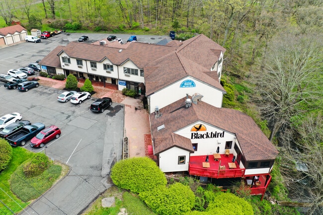


Property Detail
6 Way Rd
MFLD-000011-000000-000004
Lower Ct River Vly
Commercialofficeresidentialmixeduse
Connecticut
PC
4
AE The base floodplain where base flood elevations are provided. AE Zones are now used on new format FIRMs instead of A1-A30 Zones.
2.83 AC
2025
NW Middlesex/Middletown
2025
Hartford
580100
Hartford-West Hartford-East Hartford, CT
NEARBY LISTINGS FOR SALE OR LEASE
DEMOGRAPHICS near 6 Way Rd
1 mile
3 mile
5 mile
2025 Total Population
1,774
16,965
92,546
2030 Population
1,796
17,124
93,153
Pop Growth 2025-2030
+ 1.24%
+ 0.94%
+ 0.66%
Average Age
47
44
41
2025 Total Households
770
6,956
36,770
HH Growth 2025-2030
+ 1.30%
+ 0.92%
+ 0.60%
Median Household Inc
$113,980
$99,876
$75,651
Avg Household Size
2.30
2.40
2.30
2025 Avg HH Vehicles
2.00
2.00
2.00
Median Home Value
$397,499
$295,602
$289,967
Median Year Built
1959
1971
1964
Nearby Places
Map Layers
Map Styles
 Street
 Aerial
Transit
 Traffic
 Biking
Places
Listings with unknown addresses are not visible on the map
- Restaurants
- Banks
- Shops
- Fitness
- Groceries
PUBLIC TRANSPORTATION
COMMUTER RAIL
Drive
Walk
Distance
11 min
6.1 mi
Drive
Walk
Distance
18 min
9.3 mi
AIRPORT
Tweed/New Haven
Drive
Walk
Distance
Tweed/New Haven
39 min
25.0 mi
Bradley International
Drive
Walk
Distance
Bradley International
60 min
37.3 mi
Freight Ports
Port of New Haven
Drive
Walk
Distance
Port of New Haven
35 min
22.7 mi
SALE & LEASE HISTORY
LISTING DATE
SALE/LEASE

Sep 25, 2016
For Lease
Sep 24, 2016
For Lease
Nov 12, 2019
For Lease
May 07, 2022
For Sale
Nearby Properties
Address
Land Use
TOTAL SIZE
Lot Size
Zoning
Address
Land Use
TOTAL SIZE
Lot Size
Zoning
197,789 SF
31.92 AC
R-15
Address
Land Use
TOTAL SIZE
Lot Size
Zoning
267,249 SF
27.55 AC
R-1
Address
Land Use
TOTAL SIZE
Lot Size
Zoning
108,540 SF
22.99 AC
R-15
Address
Land Use
TOTAL SIZE
Lot Size
Zoning
23.01 AC
M
Address
Land Use
TOTAL SIZE
Lot Size
Zoning
10.38 AC
M-1
Address
Land Use
TOTAL SIZE
Lot Size
Zoning
329,296 SF
35.55 AC
IX
Address
Land Use
TOTAL SIZE
Lot Size
Zoning
339,844 SF
52.43 AC
M-4
Address
Land Use
TOTAL SIZE
Lot Size
Zoning
11.02 AC
S-R
Address
Land Use
TOTAL SIZE
Lot Size
Zoning
187,914 SF
16.13 AC
IX
Address
Land Use
TOTAL SIZE
Lot Size
Zoning
203,692 SF
21.22 AC
IX
Address
Land Use
TOTAL SIZE
Lot Size
Zoning
166,724 SF
21.79 AC
M-2
Address
Land Use
TOTAL SIZE
Lot Size
Zoning
20,330 SF
174.02 AC
WI
Address
Land Use
TOTAL SIZE
Lot Size
Zoning
115,951 SF
14.77 AC
M-1
Address
Land Use
TOTAL SIZE
Lot Size
Zoning
171,057 SF
25.06 AC
M-4
Address
Land Use
TOTAL SIZE
Lot Size
Zoning
98,894 SF
44.82 AC
WI
Address
Land Use
TOTAL SIZE
Lot Size
Zoning
18.61 AC
C-2
Address
Land Use
TOTAL SIZE
Lot Size
Zoning
3.60 AC
M-1
Address
Land Use
TOTAL SIZE
Lot Size
Zoning
8.68 AC
C-2
Address
Land Use
TOTAL SIZE
Lot Size
Zoning
326,730 SF
25.19 AC
M-1
Address
Land Use
TOTAL SIZE
Lot Size
Zoning
20.60 AC
I-4
Address
Land Use
TOTAL SIZE
Lot Size
Zoning
187,744 SF
31.68 AC
M-1
Address
Land Use
TOTAL SIZE
Lot Size
Zoning
70,112 SF
9.20 AC
WI
Address
Land Use
TOTAL SIZE
Lot Size
Zoning
69,179 SF
15.90 AC
WI
Address
Land Use
TOTAL SIZE
Lot Size
Zoning
49,299 SF
19.98 AC
IPD1
Address
Land Use
TOTAL SIZE
Lot Size
Zoning
82,685 SF
10.32 AC
IX
Address
Land Use
TOTAL SIZE
Lot Size
Zoning
168,702 SF
48.80 AC
RDD
Address
Land Use
TOTAL SIZE
Lot Size
Zoning
78,552 SF
8.10 AC
R-1
Address
Land Use
TOTAL SIZE
Lot Size
Zoning
77,230 SF
9.16 AC
R-1
Address
Land Use
TOTAL SIZE
Lot Size
Zoning
20.60 AC
RDD
Address
Land Use
TOTAL SIZE
Lot Size
Zoning
52,668 SF
14.02 AC
WI
The World's #1 Commercial Real Estate Marketplace
Connect with us
© 2026 CoStar Group
The information above has been obtained from sources believed reliable. While we do not doubt its accuracy we have not verified it and make no guarantee, warranty or representation about it. It is your responsibility to independently confirm its accuracy and completeness. Any projections, opinions, assumptions, or estimates used are for example only and do not represent the current or future performance of the property. The value of this transaction to you depends on tax and other factors which should be evaluated by your tax, financial, and legal advisors. You and your advisors should conduct a careful, independent investigation of the property to determine to your satisfaction the suitability of the property for your needs.