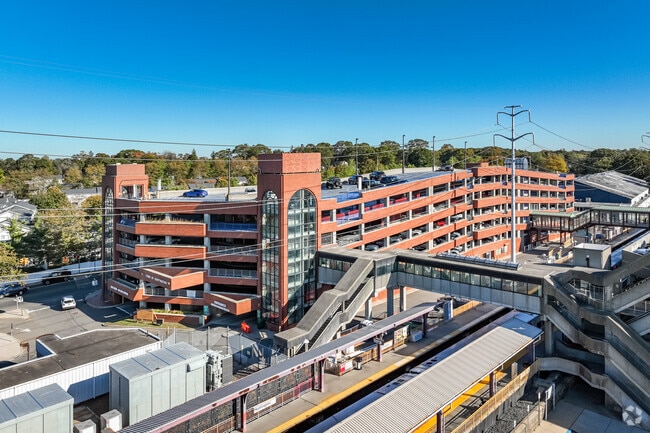
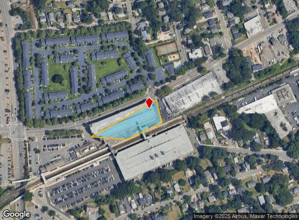
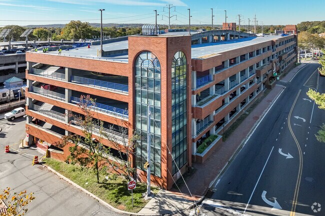
Property Record
60 Broadway, West Babylon, NY 11704
NEARBY LISTINGS FOR SALE OR LEASE
Property Detail
60 Broadway
Nassau County-Suffolk County, NY
Described
0400-147-00-04-00-002-000
BLK LOT
Vehiclerentalsvehiclesales
Suffolk
X
New York
36103C0610H
2
0
1 AC
2024
Western Suffolk
123001
Long Island (New York)
DEMOGRAPHICS near 60 Broadway
1 mile
3 mile
5 mile
2024 Total Population
18,324
82,677
156,639
2029 Population
17,797
80,751
153,684
Pop Growth 2024-2029
(2.88%)
(2.33%)
(1.89%)
Average Age
38
41
43
2024 Total Households
5,547
27,516
53,524
HH Growth 2024-2029
(2.99%)
(2.52%)
(2.05%)
Median Household Inc
$107,756
$133,272
$145,898
Avg Household Size
3.00
2.80
2.80
2024 Avg HH Vehicles
2.00
2.00
2.00
Median Home Value
$485,632
$638,515
$718,789
Median Year Built
1959
1957
1961
Nearby Places
Map Layers
Map Styles
 Street
 Aerial
Transit
 Traffic
 Biking
Places
Listings with unknown addresses are not visible on the map
- Restaurants
- Banks
- Shops
- Fitness
- Groceries
PUBLIC TRANSPORTATION
COMMUTER RAIL
Huntington Station (Port Jefferson Branch - Long Island Rail Road)
Drive
Walk
Distance
Huntington Station (Port Jefferson Branch - Long Island Rail Road)
0 min
2 min
0.1 mi
Cold Spring Harbor Station (Port Jefferson Branch - Long Island Rail Road)
Drive
Walk
Distance
Cold Spring Harbor Station (Port Jefferson Branch - Long Island Rail Road)
7 min
2.9 mi
AIRPORT
Long Island MacArthur
Drive
Walk
Distance
Long Island MacArthur
33 min
19.3 mi
John F Kennedy International
Drive
Walk
Distance
John F Kennedy International
50 min
33.6 mi
Westchester County
Drive
Walk
Distance
Westchester County
79 min
50.0 mi
Freight Ports
NY - Red Hook Container Terminal
Drive
Walk
Distance
NY - Red Hook Container Terminal
60 min
37.7 mi
Nearby Properties
Address
Land Use
TOTAL SIZE
Lot Size
Zoning
Address
Land Use
TOTAL SIZE
Lot Size
Zoning
7,431 SF
2.90 AC
VILLA
Address
Land Use
TOTAL SIZE
Lot Size
Zoning
3,739 SF
0.56 AC
VILLA
Address
Land Use
TOTAL SIZE
Lot Size
Zoning
42.21 AC
CA
Address
Land Use
TOTAL SIZE
Lot Size
Zoning
7,020 SF
2.01 AC
VILLA
Address
Land Use
TOTAL SIZE
Lot Size
Zoning
9,596 SF
0.41 AC
VILLA
Address
Land Use
TOTAL SIZE
Lot Size
Zoning
2,131 SF
0.36 AC
VILLA
Address
Land Use
TOTAL SIZE
Lot Size
Zoning
4,518 SF
1.25 AC
VILLA
Address
Land Use
TOTAL SIZE
Lot Size
Zoning
5,175 SF
1.70 AC
VILLA
Address
Land Use
TOTAL SIZE
Lot Size
Zoning
2,677 SF
0.84 AC
R15
Address
Land Use
TOTAL SIZE
Lot Size
Zoning
5,076 SF
0.14 AC
VILLA
Address
Land Use
TOTAL SIZE
Lot Size
Zoning
5,747 SF
0.99 AC
R80
Address
Land Use
TOTAL SIZE
Lot Size
Zoning
6,260 SF
2 AC
VILLA
Address
Land Use
TOTAL SIZE
Lot Size
Zoning
4,377 SF
0.99 AC
VILLA
Address
Land Use
TOTAL SIZE
Lot Size
Zoning
2,765 SF
0.27 AC
R10
Address
Land Use
TOTAL SIZE
Lot Size
Zoning
0.80 AC
CR60
Address
Land Use
TOTAL SIZE
Lot Size
Zoning
3,696 SF
1.42 AC
CR80
Address
Land Use
TOTAL SIZE
Lot Size
Zoning
1,756 SF
1.50 AC
CR80
Address
Land Use
TOTAL SIZE
Lot Size
Zoning
3,004 SF
1.38 AC
CR80
Address
Land Use
TOTAL SIZE
Lot Size
Zoning
3,604 SF
1 AC
R80
Address
Land Use
TOTAL SIZE
Lot Size
Zoning
1,980 SF
0.21 AC
R10
Address
Land Use
TOTAL SIZE
Lot Size
Zoning
2,220 SF
1.90 AC
VILLA
Address
Land Use
TOTAL SIZE
Lot Size
Zoning
2,235 SF
0.30 AC
VILLA
Address
Land Use
TOTAL SIZE
Lot Size
Zoning
2,048 SF
0.34 AC
R10
Address
Land Use
TOTAL SIZE
Lot Size
Zoning
2,003 SF
1.40 AC
CR80
Address
Land Use
TOTAL SIZE
Lot Size
Zoning
2,782 SF
0.97 AC
R40
Address
Land Use
TOTAL SIZE
Lot Size
Zoning
5,664 SF
1.10 AC
VILLA
Address
Land Use
TOTAL SIZE
Lot Size
Zoning
1,508 SF
0.47 AC
R20
Address
Land Use
TOTAL SIZE
Lot Size
Zoning
662 SF
0.13 AC
VILLA
Address
Land Use
TOTAL SIZE
Lot Size
Zoning
2,086 SF
1.60 AC
R80
Address
Land Use
TOTAL SIZE
Lot Size
Zoning
0.06 AC
VILLA
The World's #1 Commercial Real Estate Marketplace
Connect with us
© 2026 CoStar Group
The information above has been obtained from sources believed reliable. While we do not doubt its accuracy we have not verified it and make no guarantee, warranty or representation about it. It is your responsibility to independently confirm its accuracy and completeness. Any projections, opinions, assumptions, or estimates used are for example only and do not represent the current or future performance of the property. The value of this transaction to you depends on tax and other factors which should be evaluated by your tax, financial, and legal advisors. You and your advisors should conduct a careful, independent investigation of the property to determine to your satisfaction the suitability of the property for your needs.