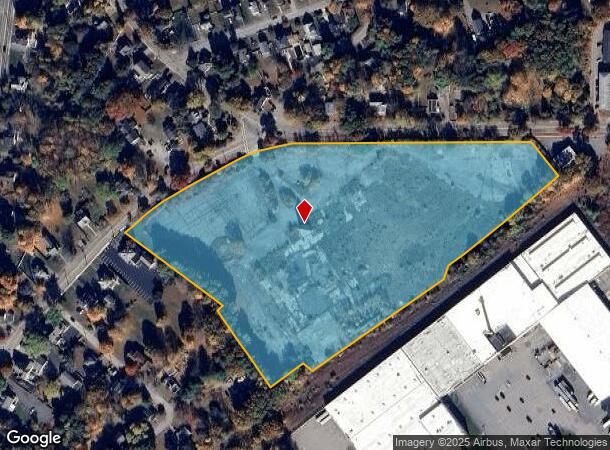
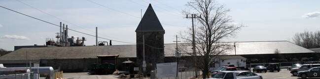
Property Record
60 Curve St, Millis, MA 02054

NEARBY LISTINGS FOR SALE OR LEASE
Property Detail
60 Curve St
Vacantlandnec
Norfolk
X
Massachusetts
25021C0161F
11.80 AC
2025
I-95 Corridor South
2025
Boston
407101
Boston-Cambridge-Newton, MA-NH
114,090 SF
MILL-000024-000000-000023
DEMOGRAPHICS near 60 Curve St
1 Mile
3 Mile
5 Mile
2024 Total Population
4,570
21,118
60,728
2029 Population
4,568
21,129
60,561
Pop Growth 2024-2029
(0.04%)
+ 0.05%
(0.27%)
Average Age
42
42
41
2024 Total Households
1,876
7,839
21,376
HH Growth 2024-2029
(0.11%)
0.00%
(0.34%)
Median Household Inc
$113,145
$148,245
$163,124
Avg Household Size
2.40
2.70
2.80
2024 Avg HH Vehicles
2.00
2.00
2.00
Median Home Value
$462,132
$621,483
$661,781
Median Year Built
1973
1974
1975
Nearby Places
Map Layers
Map Styles
 Street
 Aerial
- Restaurants
- Banks
- Shops
- Fitness
- Groceries
PUBLIC TRANSPORTATION
COMMUTER RAIL
Norfolk (Franklin Line - Massachusetts Bay Transportation Authority Commuter Rail (Purple Line))
DRIVE
WALK
Distance
Norfolk (Franklin Line - Massachusetts Bay Transportation Authority Commuter Rail (Purple Line))
8 min
4.4 mi
Walpole (Foxboro Line (Special Events Only) - Massachusetts Bay Transportation Authority Commuter Rail (Purple Line), Franklin Line - Massachusetts Bay Transportation Authority Commuter Rail (Purple Line))
DRIVE
WALK
Distance
Walpole (Foxboro Line (Special Events Only) - Massachusetts Bay Transportation Authority Commuter Rail (Purple Line), Franklin Line - Massachusetts Bay Transportation Authority Commuter Rail (Purple Line))
13 min
7.1 mi
AIRPORT
General Edward Lawrence Logan International
DRIVE
WALK
Distance
General Edward Lawrence Logan International
50 min
29.1 mi
Worcester Regional
DRIVE
WALK
Distance
Worcester Regional
59 min
36.0 mi
Freight Ports
Port of Boston
DRIVE
WALK
Distance
Port of Boston
48 min
27.4 mi
SALE & LEASE HISTORY
LISTING DATE
SALE/LEASE

Jun 19, 2017
For Lease
Nearby Properties
Address
Land Use
TOTAL SIZE
Lot Size
Zoning
Address
Land Use
TOTAL SIZE
Lot Size
Zoning
146,536 SF
3.30 AC
Address
Land Use
TOTAL SIZE
Lot Size
Zoning
231,643 SF
1.01 AC
AR-I
Address
Land Use
TOTAL SIZE
Lot Size
Zoning
138,644 SF
12.89 AC
Address
Land Use
TOTAL SIZE
Lot Size
Zoning
16.98 AC
RS
Address
Land Use
TOTAL SIZE
Lot Size
Zoning
12.65 AC
B
Address
Land Use
TOTAL SIZE
Lot Size
Zoning
28,080 SF
2.80 AC
RU
Address
Land Use
TOTAL SIZE
Lot Size
Zoning
89,572 SF
4.50 AC
RS
Address
Land Use
TOTAL SIZE
Lot Size
Zoning
157.50 AC
Address
Land Use
TOTAL SIZE
Lot Size
Zoning
5,509 SF
29.52 AC
AR-I
Address
Land Use
TOTAL SIZE
Lot Size
Zoning
12,960 SF
3.89 AC
RS
Address
Land Use
TOTAL SIZE
Lot Size
Zoning
83,772 SF
7.69 AC
Address
Land Use
TOTAL SIZE
Lot Size
Zoning
117,230 SF
12.08 AC
IE
Address
Land Use
TOTAL SIZE
Lot Size
Zoning
80,860 SF
8.77 AC
Address
Land Use
TOTAL SIZE
Lot Size
Zoning
68,052 SF
10.34 AC
CB
Address
Land Use
TOTAL SIZE
Lot Size
Zoning
71,001 SF
9.33 AC
Address
Land Use
TOTAL SIZE
Lot Size
Zoning
186.89 AC
RT
Address
Land Use
TOTAL SIZE
Lot Size
Zoning
2,108 SF
3.20 AC
Address
Land Use
TOTAL SIZE
Lot Size
Zoning
182.58 AC
RT
Address
Land Use
TOTAL SIZE
Lot Size
Zoning
43 AC
ARII
Address
Land Use
TOTAL SIZE
Lot Size
Zoning
60,000 SF
6.93 AC
INDI
Address
Land Use
TOTAL SIZE
Lot Size
Zoning
28,342 SF
3.18 AC
B
Address
Land Use
TOTAL SIZE
Lot Size
Zoning
58,342 SF
2.65 AC
AR-I
Address
Land Use
TOTAL SIZE
Lot Size
Zoning
34,867 SF
3.10 AC
Address
Land Use
TOTAL SIZE
Lot Size
Zoning
1.35 AC
RS
Address
Land Use
TOTAL SIZE
Lot Size
Zoning
0.94 AC
B
Address
Land Use
TOTAL SIZE
Lot Size
Zoning
11,085 SF
1.40 AC
Address
Land Use
TOTAL SIZE
Lot Size
Zoning
75,416 SF
5.02 AC
INDI
Address
Land Use
TOTAL SIZE
Lot Size
Zoning
237.78 AC
RC
Address
Land Use
TOTAL SIZE
Lot Size
Zoning
56,077 SF
5.52 AC
IE
Address
Land Use
TOTAL SIZE
Lot Size
Zoning
288,182 SF
17.60 AC
The World's #1 Commercial Real Estate Marketplace
Connect with us
© 2025 CoStar Group
The information above has been obtained from sources believed reliable. While we do not doubt its accuracy we have not verified it and make no guarantee, warranty or representation about it. It is your responsibility to independently confirm its accuracy and completeness. Any projections, opinions, assumptions, or estimates used are for example only and do not represent the current or future performance of the property. The value of this transaction to you depends on tax and other factors which should be evaluated by your tax, financial, and legal advisors. You and your advisors should conduct a careful, independent investigation of the property to determine to your satisfaction the suitability of the property for your needs.