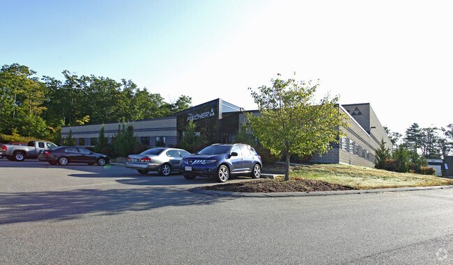
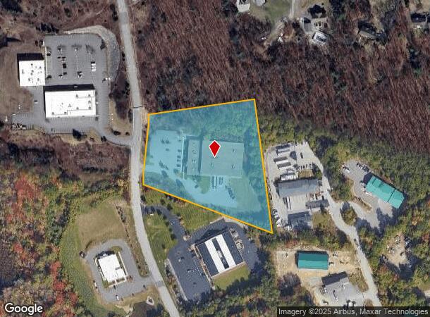
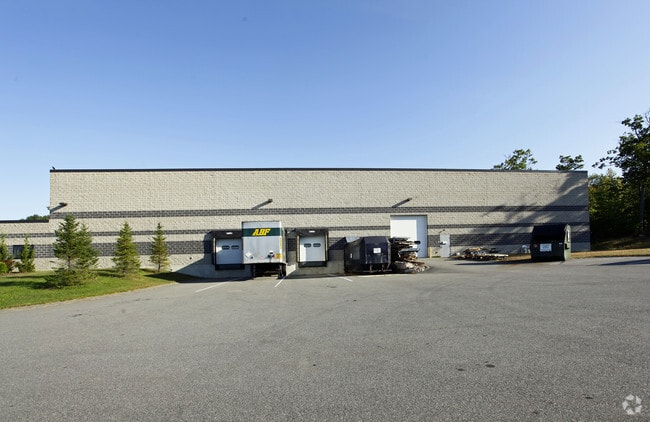
Property Record
60 Dartmouth Dr, Auburn, NH 03032
NEARBY LISTINGS FOR SALE OR LEASE
Property Detail
60 Dartmouth Dr
AUBR-000006-000018-000010
Rockingham
Commercialbuilding
New Hampshire
X
10
33013C0695E
4.72 AC
2024
Rockingham
2024
Boston
004000
Boston-Cambridge-Newton, MA-NH
31,324 SF
DEMOGRAPHICS near 60 Dartmouth Dr
1 Mile
3 Mile
5 Mile
2024 Total Population
998
23,583
105,604
2029 Population
1,028
24,255
107,621
Pop Growth 2024-2029
+ 3.01%
+ 2.85%
+ 1.91%
Average Age
42
41
40
2024 Total Households
379
9,342
44,000
HH Growth 2024-2029
+ 2.90%
+ 2.82%
+ 1.91%
Median Household Inc
$125,619
$98,286
$75,850
Avg Household Size
2.60
2.40
2.30
2024 Avg HH Vehicles
3.00
2.00
2.00
Median Home Value
$380,840
$341,275
$331,826
Median Year Built
1981
1981
1967
Nearby Places
Map Layers
Map Styles
 Street
 Aerial
- Restaurants
- Banks
- Shops
- Fitness
- Groceries
PUBLIC TRANSPORTATION
AIRPORT
Manchester Boston Regional
DRIVE
WALK
Distance
Manchester Boston Regional
20 min
9.5 mi
Portsmouth International at Pease
DRIVE
WALK
Distance
Portsmouth International at Pease
57 min
41.9 mi
Freight Ports
Port of Boston
DRIVE
WALK
Distance
Port of Boston
72 min
54.7 mi
Nearby Properties
Address
Land Use
TOTAL SIZE
Lot Size
Zoning
Address
Land Use
TOTAL SIZE
Lot Size
Zoning
6,830 SF
17.24 AC
Address
Land Use
TOTAL SIZE
Lot Size
Zoning
135,686 SF
30.23 AC
Address
Land Use
TOTAL SIZE
Lot Size
Zoning
24,064 SF
19.44 AC
Address
Land Use
TOTAL SIZE
Lot Size
Zoning
211,525 SF
93.01 AC
Address
Land Use
TOTAL SIZE
Lot Size
Zoning
2,218 SF
17.11 AC
Address
Land Use
TOTAL SIZE
Lot Size
Zoning
109,034 SF
14.30 AC
RESIDE
Address
Land Use
TOTAL SIZE
Lot Size
Zoning
38,506 SF
9.88 AC
Address
Land Use
TOTAL SIZE
Lot Size
Zoning
92,492 SF
85 AC
Address
Land Use
TOTAL SIZE
Lot Size
Zoning
131,003 SF
49.31 AC
Address
Land Use
TOTAL SIZE
Lot Size
Zoning
28,888 SF
5.50 AC
Address
Land Use
TOTAL SIZE
Lot Size
Zoning
16,000 SF
20.69 AC
Address
Land Use
TOTAL SIZE
Lot Size
Zoning
5,150 SF
13.50 AC
Address
Land Use
TOTAL SIZE
Lot Size
Zoning
56,033 SF
4.91 AC
Address
Land Use
TOTAL SIZE
Lot Size
Zoning
40,718 SF
3.42 AC
Address
Land Use
TOTAL SIZE
Lot Size
Zoning
Address
Land Use
TOTAL SIZE
Lot Size
Zoning
1,976 SF
40.02 AC
Address
Land Use
TOTAL SIZE
Lot Size
Zoning
35,478 SF
4.50 AC
Address
Land Use
TOTAL SIZE
Lot Size
Zoning
56,769 SF
20.09 AC
Address
Land Use
TOTAL SIZE
Lot Size
Zoning
282,303 SF
19.41 AC
Address
Land Use
TOTAL SIZE
Lot Size
Zoning
1,704 SF
76.35 AC
Address
Land Use
TOTAL SIZE
Lot Size
Zoning
133,900 SF
Address
Land Use
TOTAL SIZE
Lot Size
Zoning
43,494 SF
9.60 AC
Address
Land Use
TOTAL SIZE
Lot Size
Zoning
75,202 SF
3.59 AC
Address
Land Use
TOTAL SIZE
Lot Size
Zoning
41,807 SF
4.88 AC
Address
Land Use
TOTAL SIZE
Lot Size
Zoning
29,370 SF
5.31 AC
RESIDE
Address
Land Use
TOTAL SIZE
Lot Size
Zoning
23,034 SF
21.15 AC
Address
Land Use
TOTAL SIZE
Lot Size
Zoning
80,776 SF
31.92 AC
Address
Land Use
TOTAL SIZE
Lot Size
Zoning
54,723 SF
2.65 AC
Address
Land Use
TOTAL SIZE
Lot Size
Zoning
160,452 SF
20.44 AC
Address
Land Use
TOTAL SIZE
Lot Size
Zoning
104.90 AC
The World's #1 Commercial Real Estate Marketplace
Connect with us
© 2026 CoStar Group
The information above has been obtained from sources believed reliable. While we do not doubt its accuracy we have not verified it and make no guarantee, warranty or representation about it. It is your responsibility to independently confirm its accuracy and completeness. Any projections, opinions, assumptions, or estimates used are for example only and do not represent the current or future performance of the property. The value of this transaction to you depends on tax and other factors which should be evaluated by your tax, financial, and legal advisors. You and your advisors should conduct a careful, independent investigation of the property to determine to your satisfaction the suitability of the property for your needs.