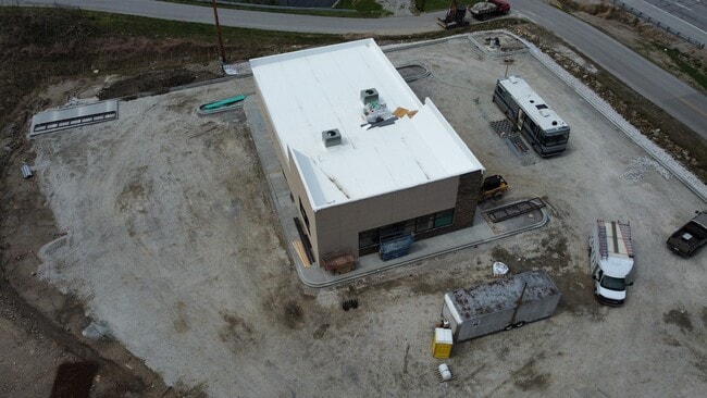
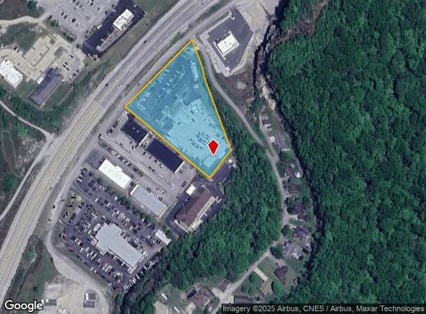
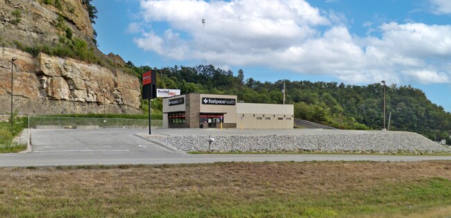
Property Record
Highway 80 East Across From Wal-Mart, Hazard, KY 41701
Current Lease Availabilities
NEARBY LISTINGS FOR SALE OR LEASE
-
-
View all Hazard listings for lease on LoopNet.com
Property Detail
Highway 80 East Across From Wal-Mart
086-00-00-015.15
Roy Campbell East 80 Sub
Commercialnec
DB 315 PG 723 05-11-2005
X
Perry
21193C0190E
Kentucky
2023
3.14 AC
2025
Kentucky East Area
970400
Other Market Areas
1,960 SF
DEMOGRAPHICS near Highway 80 East Across From Wal-Mart
1 Mile
3 Mile
5 Mile
2024 Total Population
1,169
6,592
15,100
2029 Population
1,124
6,324
14,587
Pop Growth 2024-2029
(3.85%)
(4.07%)
(3.40%)
Average Age
43
41
41
2024 Total Households
432
2,530
6,067
HH Growth 2024-2029
(3.94%)
(4.15%)
(3.33%)
Median Household Inc
$47,083
$39,851
$39,693
Avg Household Size
2.30
2.40
2.30
2024 Avg HH Vehicles
2.00
2.00
2.00
Median Home Value
$78,735
$89,955
$95,068
Median Year Built
1987
1987
1982
Nearby Places
- Restaurants
- Banks
- Shops
- Fitness
- Groceries
Nearby Properties
Address
Land Use
TOTAL SIZE
Lot Size
Zoning
Address
Land Use
TOTAL SIZE
Lot Size
Zoning
Address
Land Use
TOTAL SIZE
Lot Size
Zoning
31.07 AC
Address
Land Use
TOTAL SIZE
Lot Size
Zoning
196,287 SF
19.65 AC
R
Address
Land Use
TOTAL SIZE
Lot Size
Zoning
90,000 SF
33.98 AC
Address
Land Use
TOTAL SIZE
Lot Size
Zoning
22 AC
Address
Land Use
TOTAL SIZE
Lot Size
Zoning
16,725 SF
R
Address
Land Use
TOTAL SIZE
Lot Size
Zoning
15,750 SF
Address
Land Use
TOTAL SIZE
Lot Size
Zoning
94,000 SF
11.50 AC
R
Address
Land Use
TOTAL SIZE
Lot Size
Zoning
6,000 SF
42 AC
Address
Land Use
TOTAL SIZE
Lot Size
Zoning
50,949 SF
5.35 AC
Address
Land Use
TOTAL SIZE
Lot Size
Zoning
Address
Land Use
TOTAL SIZE
Lot Size
Zoning
50,000 SF
1.62 AC
R
Address
Land Use
TOTAL SIZE
Lot Size
Zoning
41,874 SF
1.40 AC
R
Address
Land Use
TOTAL SIZE
Lot Size
Zoning
1,100 SF
0.89 AC
Address
Land Use
TOTAL SIZE
Lot Size
Zoning
2,068 SF
6 AC
Address
Land Use
TOTAL SIZE
Lot Size
Zoning
60,285 SF
3.66 AC
Address
Land Use
TOTAL SIZE
Lot Size
Zoning
1.14 AC
Address
Land Use
TOTAL SIZE
Lot Size
Zoning
84.25 AC
Address
Land Use
TOTAL SIZE
Lot Size
Zoning
19,730 SF
4 AC
Address
Land Use
TOTAL SIZE
Lot Size
Zoning
12,238 SF
8 AC
Address
Land Use
TOTAL SIZE
Lot Size
Zoning
33,618 SF
16 AC
Address
Land Use
TOTAL SIZE
Lot Size
Zoning
9,500 SF
0.80 AC
Address
Land Use
TOTAL SIZE
Lot Size
Zoning
2.45 AC
Address
Land Use
TOTAL SIZE
Lot Size
Zoning
7.43 AC
R
Address
Land Use
TOTAL SIZE
Lot Size
Zoning
Address
Land Use
TOTAL SIZE
Lot Size
Zoning
Address
Land Use
TOTAL SIZE
Lot Size
Zoning
3,780 SF
Address
Land Use
TOTAL SIZE
Lot Size
Zoning
8,835 SF
5.51 AC
Address
Land Use
TOTAL SIZE
Lot Size
Zoning
10,028 SF
The World's #1 Commercial Real Estate Marketplace
Connect with us
© 2025 CoStar Group
The information above has been obtained from sources believed reliable. While we do not doubt its accuracy we have not verified it and make no guarantee, warranty or representation about it. It is your responsibility to independently confirm its accuracy and completeness. Any projections, opinions, assumptions, or estimates used are for example only and do not represent the current or future performance of the property. The value of this transaction to you depends on tax and other factors which should be evaluated by your tax, financial, and legal advisors. You and your advisors should conduct a careful, independent investigation of the property to determine to your satisfaction the suitability of the property for your needs.