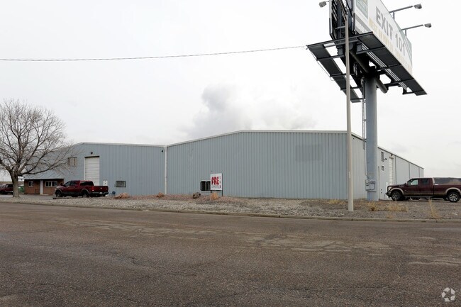
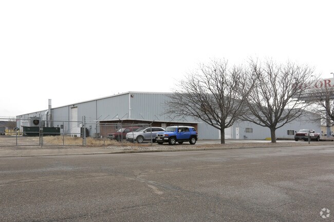
Property Record
60 Greenhorn Dr, Pueblo, CO 81004


NEARBY LISTINGS FOR SALE OR LEASE
Property Detail
60 Greenhorn Dr
Pueblo, CO
Com-Minnequa Ip
1-5-24-0-01-002
LOT 10 MINNEQUA INDUSTRIAL PARK 1ST
Industrialacreage
Pueblo
X
Colorado
08101C0730D
10
2024
2.49 AC
2024
Colorado East Area
002806
Other Market Areas
44,250 SF
DEMOGRAPHICS near 60 Greenhorn Dr
1 Mile
3 Mile
5 Mile
2024 Total Population
1,721
40,686
76,896
2029 Population
1,778
41,632
78,653
Pop Growth 2024-2029
+ 3.31%
+ 2.33%
+ 2.28%
Average Age
39
40
41
2024 Total Households
683
16,650
31,350
HH Growth 2024-2029
+ 3.37%
+ 2.41%
+ 2.41%
Median Household Inc
$40,465
$47,824
$47,352
Avg Household Size
2.30
2.30
2.30
2024 Avg HH Vehicles
1.00
2.00
2.00
Median Home Value
$187,585
$199,763
$220,823
Median Year Built
1956
1962
1961
Nearby Places
Map Layers
Map Styles
 Street
 Aerial
- Restaurants
- Banks
- Shops
- Fitness
- Groceries
Nearby Properties
Address
Land Use
TOTAL SIZE
Lot Size
Zoning
Address
Land Use
TOTAL SIZE
Lot Size
Zoning
17,710 SF
49.97 AC
Address
Land Use
TOTAL SIZE
Lot Size
Zoning
4,492,279 SF
488.39 AC
Address
Land Use
TOTAL SIZE
Lot Size
Zoning
650,514 SF
137.35 AC
I-3
Address
Land Use
TOTAL SIZE
Lot Size
Zoning
79,394 SF
5.57 AC
R5:RES/MUL
Address
Land Use
TOTAL SIZE
Lot Size
Zoning
56,088 SF
4 AC
Address
Land Use
TOTAL SIZE
Lot Size
Zoning
33,866 SF
3.34 AC
Address
Land Use
TOTAL SIZE
Lot Size
Zoning
199,914 SF
13.48 AC
B4:COMM/RE
Address
Land Use
TOTAL SIZE
Lot Size
Zoning
1,070,193 SF
43.08 AC
R5:RES/MUL
Address
Land Use
TOTAL SIZE
Lot Size
Zoning
27,682 SF
1.85 AC
S-1
Address
Land Use
TOTAL SIZE
Lot Size
Zoning
25,714 SF
17.61 AC
Address
Land Use
TOTAL SIZE
Lot Size
Zoning
45,219 SF
4.46 AC
Address
Land Use
TOTAL SIZE
Lot Size
Zoning
35,530 SF
0.55 AC
R-4
Address
Land Use
TOTAL SIZE
Lot Size
Zoning
19,763 SF
2.50 AC
R2:RES/1 F
Address
Land Use
TOTAL SIZE
Lot Size
Zoning
86,458 SF
20 AC
I3:IND/HEA
Address
Land Use
TOTAL SIZE
Lot Size
Zoning
136,337 SF
14.81 AC
PUD
Address
Land Use
TOTAL SIZE
Lot Size
Zoning
16,800 SF
6.02 AC
Address
Land Use
TOTAL SIZE
Lot Size
Zoning
71,751 SF
2.73 AC
R3:RES/2 F
Address
Land Use
TOTAL SIZE
Lot Size
Zoning
28,490 SF
0.23 AC
R4:RES/MUL
Address
Land Use
TOTAL SIZE
Lot Size
Zoning
12,150 SF
1.10 AC
Address
Land Use
TOTAL SIZE
Lot Size
Zoning
453,460 SF
30.80 AC
I3:IND/HEA
Address
Land Use
TOTAL SIZE
Lot Size
Zoning
42,408 SF
5.97 AC
B1:COMM/NG
Address
Land Use
TOTAL SIZE
Lot Size
Zoning
81,140 SF
3.22 AC
Address
Land Use
TOTAL SIZE
Lot Size
Zoning
154,378 SF
14.33 AC
B4:COMM/RE
Address
Land Use
TOTAL SIZE
Lot Size
Zoning
54,947 SF
2.03 AC
B3:COMM/H&
Address
Land Use
TOTAL SIZE
Lot Size
Zoning
663.63 AC
Address
Land Use
TOTAL SIZE
Lot Size
Zoning
29,338 SF
0.89 AC
B-4
Address
Land Use
TOTAL SIZE
Lot Size
Zoning
12,600 SF
0.23 AC
I3:IND/HEA
Address
Land Use
TOTAL SIZE
Lot Size
Zoning
61,485 SF
2.39 AC
I3:IND/HEA
Address
Land Use
TOTAL SIZE
Lot Size
Zoning
83,900 SF
0.83 AC
B-3
Address
Land Use
TOTAL SIZE
Lot Size
Zoning
95,309 SF
8.74 AC
B4:COMM/RE
The World's #1 Commercial Real Estate Marketplace
Connect with us
© 2025 CoStar Group
The information above has been obtained from sources believed reliable. While we do not doubt its accuracy we have not verified it and make no guarantee, warranty or representation about it. It is your responsibility to independently confirm its accuracy and completeness. Any projections, opinions, assumptions, or estimates used are for example only and do not represent the current or future performance of the property. The value of this transaction to you depends on tax and other factors which should be evaluated by your tax, financial, and legal advisors. You and your advisors should conduct a careful, independent investigation of the property to determine to your satisfaction the suitability of the property for your needs.