Property Record
22 W Highway Hwy W, Milledgeville, GA 31061
NEARBY LISTINGS FOR SALE OR LEASE
Property Detail
22 W Highway Hwy W
068-001D
Comm-Slandy Cir
Officebuilding
PARCEL S/S BLANDY WAY DB566/200 PB21/47
X
Baldwin
13009C0135D
Georgia
2025
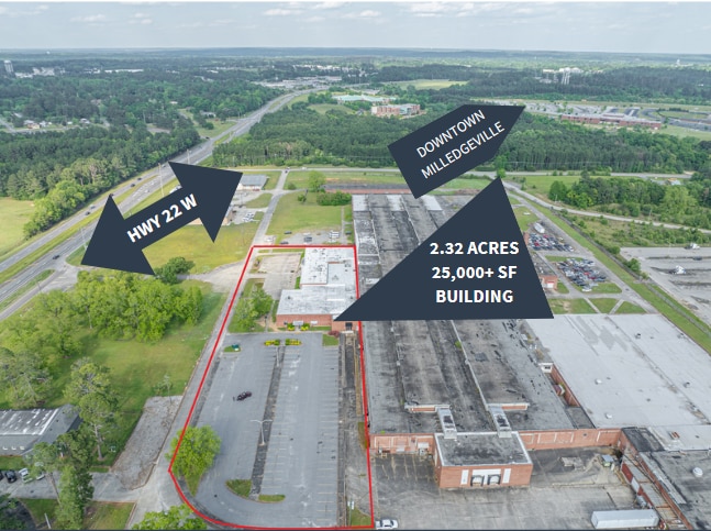
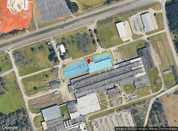
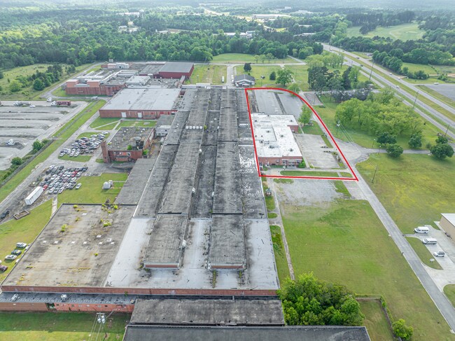
2.32 AC
2025
Georgia South Area
970400
Other Market Areas
25,360 SF
Milledgeville, GA
DEMOGRAPHICS near 22 W Highway Hwy W
1 Mile
3 Mile
5 Mile
2024 Total Population
240
14,163
27,076
2029 Population
236
14,111
27,052
Pop Growth 2024-2029
(1.67%)
(0.37%)
(0.09%)
Average Age
41
36
38
2024 Total Households
93
5,599
10,651
HH Growth 2024-2029
(2.15%)
(0.45%)
(0.13%)
Median Household Inc
$79,297
$36,086
$40,112
Avg Household Size
2.50
2.20
2.30
2024 Avg HH Vehicles
2.00
2.00
2.00
Median Home Value
$253,333
$166,630
$163,448
Median Year Built
1986
1979
1980
Nearby Places
- Restaurants
- Banks
- Shops
- Fitness
- Groceries
SALE & LEASE HISTORY
LISTING DATE
SALE/LEASE

May 10, 2024
For Sale
Nearby Properties
Address
Land Use
TOTAL SIZE
Lot Size
Zoning
Address
Land Use
TOTAL SIZE
Lot Size
Zoning
19.20 AC
RESIDENTIA
Address
Land Use
TOTAL SIZE
Lot Size
Zoning
29.65 AC
RESIDENTIA
Address
Land Use
TOTAL SIZE
Lot Size
Zoning
31,112 SF
13.98 AC
RESIDENTIA
Address
Land Use
TOTAL SIZE
Lot Size
Zoning
59,500 SF
44 AC
RESIDENTIA
Address
Land Use
TOTAL SIZE
Lot Size
Zoning
430,556 SF
32.09 AC
RESIDENTIA
Address
Land Use
TOTAL SIZE
Lot Size
Zoning
74,448 SF
49 AC
RESIDENTIA
Address
Land Use
TOTAL SIZE
Lot Size
Zoning
92,400 SF
30 AC
RESIDENTIA
Address
Land Use
TOTAL SIZE
Lot Size
Zoning
118,521 SF
1.86 AC
RESIDENTIA
Address
Land Use
TOTAL SIZE
Lot Size
Zoning
34,953 SF
2.17 AC
RESIDENTIA
Address
Land Use
TOTAL SIZE
Lot Size
Zoning
2.50 AC
RESIDENTIA
Address
Land Use
TOTAL SIZE
Lot Size
Zoning
49,412 SF
0.26 AC
RESIDENTIA
Address
Land Use
TOTAL SIZE
Lot Size
Zoning
313,804 SF
17.50 AC
RESIDENTIA
Address
Land Use
TOTAL SIZE
Lot Size
Zoning
386,880 SF
17.52 AC
RESIDENTIA
Address
Land Use
TOTAL SIZE
Lot Size
Zoning
67,500 SF
1.70 AC
RESIDENTIA
Address
Land Use
TOTAL SIZE
Lot Size
Zoning
30.05 AC
RESIDENTIA
Address
Land Use
TOTAL SIZE
Lot Size
Zoning
866,082 SF
6.61 AC
RESIDENTIA
Address
Land Use
TOTAL SIZE
Lot Size
Zoning
40,800 SF
0.14 AC
RESIDENTIA
Address
Land Use
TOTAL SIZE
Lot Size
Zoning
70,460 SF
14.93 AC
COMMERCIAL
Address
Land Use
TOTAL SIZE
Lot Size
Zoning
127,410 SF
25.98 AC
RESIDENTIA
Address
Land Use
TOTAL SIZE
Lot Size
Zoning
228,844 SF
3.20 AC
RESIDENTIA
Address
Land Use
TOTAL SIZE
Lot Size
Zoning
554,286 SF
24.17 AC
RESIDENTIA
Address
Land Use
TOTAL SIZE
Lot Size
Zoning
19.50 AC
RESIDENTIA
Address
Land Use
TOTAL SIZE
Lot Size
Zoning
139,950 SF
27.92 AC
RESIDENTIA
Address
Land Use
TOTAL SIZE
Lot Size
Zoning
46,858 SF
2.64 AC
RESIDENTIA
Address
Land Use
TOTAL SIZE
Lot Size
Zoning
50,580 SF
7.61 AC
COMMERCIAL
Address
Land Use
TOTAL SIZE
Lot Size
Zoning
76,582 SF
3.17 AC
RESIDENTIA
Address
Land Use
TOTAL SIZE
Lot Size
Zoning
37,296 SF
13.50 AC
RESIDENTIA
Address
Land Use
TOTAL SIZE
Lot Size
Zoning
71,162 SF
2.30 AC
COMMERCIAL
Address
Land Use
TOTAL SIZE
Lot Size
Zoning
160,604 SF
8.29 AC
RESIDENTIA
Address
Land Use
TOTAL SIZE
Lot Size
Zoning
1,200 SF
10 AC
UNZONED RU
The World's #1 Commercial Real Estate Marketplace
Connect with us
© 2025 CoStar Group
The information above has been obtained from sources believed reliable. While we do not doubt its accuracy we have not verified it and make no guarantee, warranty or representation about it. It is your responsibility to independently confirm its accuracy and completeness. Any projections, opinions, assumptions, or estimates used are for example only and do not represent the current or future performance of the property. The value of this transaction to you depends on tax and other factors which should be evaluated by your tax, financial, and legal advisors. You and your advisors should conduct a careful, independent investigation of the property to determine to your satisfaction the suitability of the property for your needs.