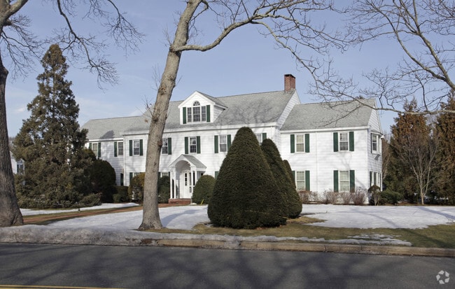
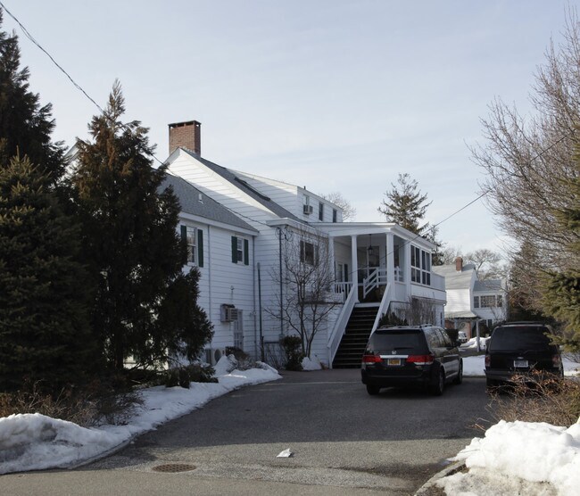
Property Record
60 Mill Rd, Westhampton Beach, NY 11978

Property Detail
60 Mill Rd
0905-012-00-02-00-042-000
87LD EQ+3500 90 ALT/ADD1775
Funeralhome
Suffolk
HC
New York
B and X Area of moderate flood hazard, usually the area between the limits of the 100-year and 500-year floods.
42
2024
0.82 AC
2025
Eastern Suffolk
158609
Long Island (New York)
6,680 SF
Nassau County-Suffolk County, NY
NEARBY LISTINGS FOR SALE OR LEASE
DEMOGRAPHICS near 60 Mill Rd
1 mile
3 mile
5 mile
2025 Total Population
4,846
14,684
23,753
2030 Population
5,363
15,902
25,181
Pop Growth 2025-2030
+ 10.67%
+ 8.29%
+ 6.01%
Average Age
44
45
45
2025 Total Households
1,903
5,616
9,010
HH Growth 2025-2030
+ 10.98%
+ 8.55%
+ 6.07%
Median Household Inc
$122,901
$119,487
$120,509
Avg Household Size
2.50
2.50
2.60
2025 Avg HH Vehicles
2.00
2.00
2.00
Median Home Value
$1,024,902
$1,005,276
$928,796
Median Year Built
1976
1980
1979
Nearby Places
Map Layers
Map Styles
 Street
 Aerial
Layers
 Traffic
 Biking
Places
Listings with unknown addresses are not visible on the map
- Restaurants
- Banks
- Shops
- Fitness
- Groceries
PUBLIC TRANSPORTATION
COMMUTER RAIL
Westhampton Station (Montauk Branch - Long Island Rail Road)
Drive
Walk
Distance
Westhampton Station (Montauk Branch - Long Island Rail Road)
4 min
1.6 mi
Speonk Station (Montauk Branch - Long Island Rail Road)
Drive
Walk
Distance
Speonk Station (Montauk Branch - Long Island Rail Road)
7 min
4.0 mi
AIRPORT
Long Island MacArthur
Drive
Walk
Distance
Long Island MacArthur
42 min
27.0 mi
Nearby Properties
Address
Land Use
TOTAL SIZE
Lot Size
Zoning
Address
Land Use
TOTAL SIZE
Lot Size
Zoning
1,229.10 AC
LI200
Address
Land Use
TOTAL SIZE
Lot Size
Zoning
53,067 SF
6.20 AC
R2
Address
Land Use
TOTAL SIZE
Lot Size
Zoning
55,202 SF
18.50 AC
R2
Address
Land Use
TOTAL SIZE
Lot Size
Zoning
8.26 AC
LI200
Address
Land Use
TOTAL SIZE
Lot Size
Zoning
68,676 SF
9.70 AC
CR200
Address
Land Use
TOTAL SIZE
Lot Size
Zoning
11.41 AC
LI200
Address
Land Use
TOTAL SIZE
Lot Size
Zoning
18.28 AC
CR200
Address
Land Use
TOTAL SIZE
Lot Size
Zoning
15,084 SF
10.25 AC
R40
Address
Land Use
TOTAL SIZE
Lot Size
Zoning
31,393 SF
4.90 AC
R3
Address
Land Use
TOTAL SIZE
Lot Size
Zoning
9,191 SF
14.39 AC
VILLA
Address
Land Use
TOTAL SIZE
Lot Size
Zoning
28,458 SF
9.60 AC
LI40
Address
Land Use
TOTAL SIZE
Lot Size
Zoning
2,947 SF
8.59 AC
VILLA
Address
Land Use
TOTAL SIZE
Lot Size
Zoning
28.62 AC
R40
Address
Land Use
TOTAL SIZE
Lot Size
Zoning
17,772 SF
8.86 AC
VILLA
Address
Land Use
TOTAL SIZE
Lot Size
Zoning
22,629 SF
2.10 AC
VILLA
Address
Land Use
TOTAL SIZE
Lot Size
Zoning
19.50 AC
PC
Address
Land Use
TOTAL SIZE
Lot Size
Zoning
36,918 SF
6.27 AC
R40
Address
Land Use
TOTAL SIZE
Lot Size
Zoning
26,798 SF
34.06 AC
CR200
Address
Land Use
TOTAL SIZE
Lot Size
Zoning
13.90 AC
PC
Address
Land Use
TOTAL SIZE
Lot Size
Zoning
7,270 SF
4.20 AC
R2
Address
Land Use
TOTAL SIZE
Lot Size
Zoning
6,673 SF
4.50 AC
R20
Address
Land Use
TOTAL SIZE
Lot Size
Zoning
28,544 SF
4.70 AC
R1
Address
Land Use
TOTAL SIZE
Lot Size
Zoning
16,854 SF
11.95 AC
OD
Address
Land Use
TOTAL SIZE
Lot Size
Zoning
6,720 SF
1.96 AC
VILLA
Address
Land Use
TOTAL SIZE
Lot Size
Zoning
20,822 SF
2.60 AC
B1
Address
Land Use
TOTAL SIZE
Lot Size
Zoning
6.42 AC
LI200
Address
Land Use
TOTAL SIZE
Lot Size
Zoning
1,792 SF
59.30 AC
RTPDD
Address
Land Use
TOTAL SIZE
Lot Size
Zoning
2,427 SF
3.80 AC
R3
Address
Land Use
TOTAL SIZE
Lot Size
Zoning
10.64 AC
PC
Address
Land Use
TOTAL SIZE
Lot Size
Zoning
8,851 SF
2.97 AC
R1
The World's #1 Commercial Real Estate Marketplace
Connect with us
© 2026 CoStar Group
The information above has been obtained from sources believed reliable. While we do not doubt its accuracy we have not verified it and make no guarantee, warranty or representation about it. It is your responsibility to independently confirm its accuracy and completeness. Any projections, opinions, assumptions, or estimates used are for example only and do not represent the current or future performance of the property. The value of this transaction to you depends on tax and other factors which should be evaluated by your tax, financial, and legal advisors. You and your advisors should conduct a careful, independent investigation of the property to determine to your satisfaction the suitability of the property for your needs.