Property Record
60 Pleasant Hill Rd, Nesbit, MS 38651
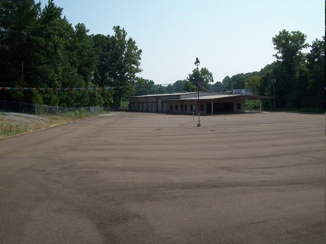

Property Detail
60 Pleasant Hill Rd
2079300000001200
30-2-7 PT SW1/4 NW1/4
Communitycenter
Desoto
C-2
Mississippi
AE The base floodplain where base flood elevations are provided. AE Zones are now used on new format FIRMs instead of A1-A30 Zones.
12
2025
7 AC
2025
DeSoto
070634
Memphis
5,025 SF
Memphis, TN-MS-AR
NEARBY LISTINGS FOR SALE OR LEASE
DEMOGRAPHICS near 60 Pleasant Hill Rd
1 mile
3 mile
5 mile
2025 Total Population
1,825
12,877
53,443
2030 Population
1,928
13,519
56,045
Pop Growth 2025-2030
+ 5.64%
+ 4.99%
+ 4.87%
Average Age
40
39
39
2025 Total Households
645
4,535
19,734
HH Growth 2025-2030
+ 5.74%
+ 4.92%
+ 4.91%
Median Household Inc
$93,951
$95,882
$86,287
Avg Household Size
2.80
2.80
2.70
2025 Avg HH Vehicles
2.00
2.00
2.00
Median Home Value
$357,253
$359,608
$323,973
Median Year Built
2002
2002
2000
Nearby Places
Map Layers
Map Styles
 Street
 Aerial
Layers
 Traffic
 Biking
Places
Listings with unknown addresses are not visible on the map
- Restaurants
- Banks
- Shops
- Fitness
- Groceries
PUBLIC TRANSPORTATION
AIRPORT
Memphis International
Drive
Walk
Distance
Memphis International
22 min
13.8 mi
Nearby Properties
Address
Land Use
TOTAL SIZE
Lot Size
Zoning
Address
Land Use
TOTAL SIZE
Lot Size
Zoning
436,932 SF
153.19 AC
M-1
Address
Land Use
TOTAL SIZE
Lot Size
Zoning
1,197,486 SF
59.47 AC
PBP
Address
Land Use
TOTAL SIZE
Lot Size
Zoning
906,200 SF
73.05 AC
PBP
Address
Land Use
TOTAL SIZE
Lot Size
Zoning
946,430 SF
62.60 AC
PBP
Address
Land Use
TOTAL SIZE
Lot Size
Zoning
412,218 SF
37.80 AC
PBP
Address
Land Use
TOTAL SIZE
Lot Size
Zoning
864,160 SF
44.14 AC
PBP
Address
Land Use
TOTAL SIZE
Lot Size
Zoning
473,820 SF
56.29 AC
PBP
Address
Land Use
TOTAL SIZE
Lot Size
Zoning
581,530 SF
51.64 AC
PBP
Address
Land Use
TOTAL SIZE
Lot Size
Zoning
553,179 SF
36.77 AC
PBP
Address
Land Use
TOTAL SIZE
Lot Size
Zoning
514,885 SF
35.91 AC
PBP
Address
Land Use
TOTAL SIZE
Lot Size
Zoning
262,006 SF
25.85 AC
PBP
Address
Land Use
TOTAL SIZE
Lot Size
Zoning
300,764 SF
22.13 AC
PBP
Address
Land Use
TOTAL SIZE
Lot Size
Zoning
29,738 SF
15 AC
C-2
Address
Land Use
TOTAL SIZE
Lot Size
Zoning
216,320 SF
30 AC
PBP
Address
Land Use
TOTAL SIZE
Lot Size
Zoning
202,306 SF
15.07 AC
PBP
Address
Land Use
TOTAL SIZE
Lot Size
Zoning
64,797 SF
13.91 AC
M-1
Address
Land Use
TOTAL SIZE
Lot Size
Zoning
15.10 AC
C-2
Address
Land Use
TOTAL SIZE
Lot Size
Zoning
23,530 SF
9.35 AC
M-1
Address
Land Use
TOTAL SIZE
Lot Size
Zoning
35,000 SF
4.72 AC
PUD
Address
Land Use
TOTAL SIZE
Lot Size
Zoning
30,009 SF
4.31 AC
M-1
Address
Land Use
TOTAL SIZE
Lot Size
Zoning
20,120 SF
3.43 AC
PUD
Address
Land Use
TOTAL SIZE
Lot Size
Zoning
10,200 SF
3.69 AC
C-2
Address
Land Use
TOTAL SIZE
Lot Size
Zoning
5,518 SF
128.60 AC
PUD
Address
Land Use
TOTAL SIZE
Lot Size
Zoning
5,031 SF
3.05 AC
C-1
Address
Land Use
TOTAL SIZE
Lot Size
Zoning
7,500 SF
3.90 AC
C-4
Address
Land Use
TOTAL SIZE
Lot Size
Zoning
987 SF
41.70 AC
A-R
Address
Land Use
TOTAL SIZE
Lot Size
Zoning
6,328 SF
1.71 AC
C-1
Address
Land Use
TOTAL SIZE
Lot Size
Zoning
3,611 SF
1.01 AC
C-2
Address
Land Use
TOTAL SIZE
Lot Size
Zoning
7,541 SF
1.22 AC
M-1
Address
Land Use
TOTAL SIZE
Lot Size
Zoning
1.29 AC
M-1
The World's #1 Commercial Real Estate Marketplace
Connect with us
© 2026 CoStar Group
The information above has been obtained from sources believed reliable. While we do not doubt its accuracy we have not verified it and make no guarantee, warranty or representation about it. It is your responsibility to independently confirm its accuracy and completeness. Any projections, opinions, assumptions, or estimates used are for example only and do not represent the current or future performance of the property. The value of this transaction to you depends on tax and other factors which should be evaluated by your tax, financial, and legal advisors. You and your advisors should conduct a careful, independent investigation of the property to determine to your satisfaction the suitability of the property for your needs.