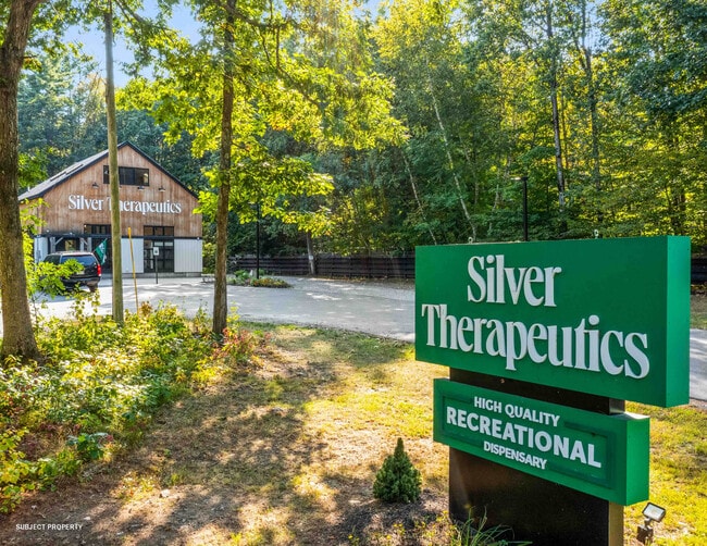
Property Record
60 Route 236, Berwick, ME 03901


Save to a Folder
{{folder.Name}}
{{folder.ListingIds.length}} Properties
{{folder.ListingIds.length}} Property
Create a New Folder
Property Detail
60 Route 236
Departmentstore
York
RC/I
Maine
B and X Area of moderate flood hazard, usually the area between the limits of the 100-year and 500-year floods.
0.94 AC
2025
York County
2025
Portland/South Portland
032002
Portland-South Portland, ME
2,160 SF
BERW-000057R-000000-000055
NEARBY LISTINGS FOR SALE OR LEASE
DEMOGRAPHICS near 60 Route 236
1 mile
3 mile
5 mile
2025 Total Population
5,375
19,594
44,795
2030 Population
5,440
19,745
45,466
Pop Growth 2025-2030
+ 1.21%
+ 0.77%
+ 1.50%
Average Age
39
40
40
2025 Total Households
2,301
8,107
18,892
HH Growth 2025-2030
+ 1.17%
+ 0.75%
+ 1.61%
Median Household Inc
$79,975
$84,943
$85,391
Avg Household Size
2.30
2.40
2.30
2025 Avg HH Vehicles
2.00
2.00
2.00
Median Home Value
$346,349
$352,467
$376,826
Median Year Built
1949
1969
1973
Nearby Places
Map Layers
Map Styles
 Street
 Aerial
Layers
 Traffic
 Biking
Places
Listings with unknown addresses are not visible on the map
- Restaurants
- Banks
- Shops
- Fitness
- Groceries
PUBLIC TRANSPORTATION
COMMUTER RAIL
Dover (Downeaster - Amtrak)
Drive
Walk
Distance
Dover (Downeaster - Amtrak)
14 min
6.1 mi
AIRPORT
Portsmouth International at Pease
Drive
Walk
Distance
Portsmouth International at Pease
30 min
16.5 mi
Freight Ports
Portland, ME
Drive
Walk
Distance
Portland, ME
63 min
45.7 mi
SALE & LEASE HISTORY
LISTING DATE
SALE/LEASE

Oct 08, 2024
For Sale
Nearby Properties
Address
Land Use
TOTAL SIZE
Lot Size
Zoning
Address
Land Use
TOTAL SIZE
Lot Size
Zoning
50.50 AC
R2
Address
Land Use
TOTAL SIZE
Lot Size
Zoning
18.65 AC
B
Address
Land Use
TOTAL SIZE
Lot Size
Zoning
19.55 AC
B
Address
Land Use
TOTAL SIZE
Lot Size
Zoning
77,721 SF
22.63 AC
R1
Address
Land Use
TOTAL SIZE
Lot Size
Zoning
15,904 SF
54 AC
R1 RES
Address
Land Use
TOTAL SIZE
Lot Size
Zoning
428,428 SF
210.42 AC
CI
Address
Land Use
TOTAL SIZE
Lot Size
Zoning
Address
Land Use
TOTAL SIZE
Lot Size
Zoning
112,173 SF
21 AC
CI
Address
Land Use
TOTAL SIZE
Lot Size
Zoning
178.76 AC
AI
Address
Land Use
TOTAL SIZE
Lot Size
Zoning
197,921 SF
RC
Address
Land Use
TOTAL SIZE
Lot Size
Zoning
121,456 SF
25.46 AC
R1&R2
Address
Land Use
TOTAL SIZE
Lot Size
Zoning
104,186 SF
21.50 AC
CI
Address
Land Use
TOTAL SIZE
Lot Size
Zoning
101,553 SF
35.40 AC
R2&R3
Address
Land Use
TOTAL SIZE
Lot Size
Zoning
14.50 AC
CI
Address
Land Use
TOTAL SIZE
Lot Size
Zoning
19,382 SF
7.91 AC
V/C
Address
Land Use
TOTAL SIZE
Lot Size
Zoning
46.98 AC
CI
Address
Land Use
TOTAL SIZE
Lot Size
Zoning
18.10 AC
B
Address
Land Use
TOTAL SIZE
Lot Size
Zoning
12 AC
R2
Address
Land Use
TOTAL SIZE
Lot Size
Zoning
54,085 SF
27 AC
R3
Address
Land Use
TOTAL SIZE
Lot Size
Zoning
6.10 AC
R2
Address
Land Use
TOTAL SIZE
Lot Size
Zoning
78,615 SF
4.90 AC
MY
Address
Land Use
TOTAL SIZE
Lot Size
Zoning
71.58 AC
R2&R3
Address
Land Use
TOTAL SIZE
Lot Size
Zoning
12,988 SF
2.97 AC
B2 BUS
Address
Land Use
TOTAL SIZE
Lot Size
Zoning
19,032 SF
8.40 AC
B1 BUS
Address
Land Use
TOTAL SIZE
Lot Size
Zoning
3.87 AC
CI
Address
Land Use
TOTAL SIZE
Lot Size
Zoning
4,536 SF
131.95 AC
R2 RES
Address
Land Use
TOTAL SIZE
Lot Size
Zoning
32,829 SF
5.19 AC
CI
Address
Land Use
TOTAL SIZE
Lot Size
Zoning
42.93 AC
CI
Address
Land Use
TOTAL SIZE
Lot Size
Zoning
16,680 SF
9.84 AC
CI
Address
Land Use
TOTAL SIZE
Lot Size
Zoning
21,424 SF
4.59 AC
CI
The World's #1 Commercial Real Estate Marketplace
Connect with us
© 2026 CoStar Group
The information above has been obtained from sources believed reliable. While we do not doubt its accuracy we have not verified it and make no guarantee, warranty or representation about it. It is your responsibility to independently confirm its accuracy and completeness. Any projections, opinions, assumptions, or estimates used are for example only and do not represent the current or future performance of the property. The value of this transaction to you depends on tax and other factors which should be evaluated by your tax, financial, and legal advisors. You and your advisors should conduct a careful, independent investigation of the property to determine to your satisfaction the suitability of the property for your needs.