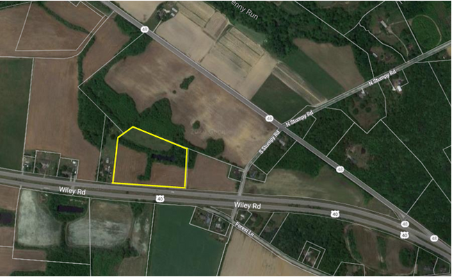
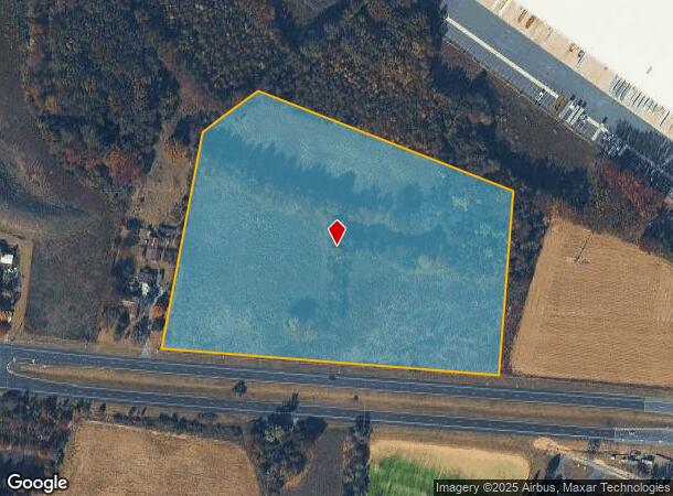
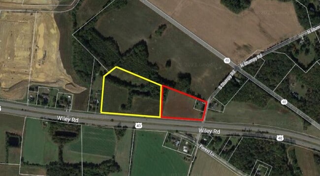
Property Record
60 Route 40, Penns Grove, NJ 08069
NEARBY LISTINGS FOR SALE OR LEASE
Property Detail
60 Route 40
02 00250-0000-00005-0000-QFARM
Salem
Vacantlandnec
New Jersey
X
5
34033C0066C
11.73 AC
2023
Salem County
2025
Philadelphia
020600
Philadelphia-Camden-Wilmington, PA-NJ-DE-MD
DEMOGRAPHICS near 60 Route 40
1 Mile
3 Mile
5 Mile
2024 Total Population
518
3,760
22,017
2029 Population
520
3,802
22,382
Pop Growth 2024-2029
+ 0.39%
+ 1.12%
+ 1.66%
Average Age
47
44
41
2024 Total Households
204
1,466
8,347
HH Growth 2024-2029
+ 0.49%
+ 1.16%
+ 1.57%
Median Household Inc
$68,099
$76,304
$70,361
Avg Household Size
2.30
2.40
2.60
2024 Avg HH Vehicles
2.00
2.00
2.00
Median Home Value
$215,942
$185,873
$181,737
Median Year Built
1954
1957
1960
Nearby Places
Map Layers
Map Styles
 Street
 Aerial
- Restaurants
- Banks
- Shops
- Fitness
- Groceries
PUBLIC TRANSPORTATION
AIRPORT
Philadelphia International
DRIVE
WALK
Distance
Philadelphia International
37 min
24.3 mi
Freight Ports
Port of Wilmington, RI
DRIVE
WALK
Distance
Port of Wilmington, RI
19 min
10.6 mi
SALE & LEASE HISTORY
LISTING DATE
SALE/LEASE

Jul 28, 2020
For Sale
Nearby Properties
Address
Land Use
TOTAL SIZE
Lot Size
Zoning
Address
Land Use
TOTAL SIZE
Lot Size
Zoning
118.77 AC
GC
Address
Land Use
TOTAL SIZE
Lot Size
Zoning
150.60 AC
AG
Address
Land Use
TOTAL SIZE
Lot Size
Zoning
47.91 AC
IC
Address
Land Use
TOTAL SIZE
Lot Size
Zoning
Address
Land Use
TOTAL SIZE
Lot Size
Zoning
41.27 AC
GC
Address
Land Use
TOTAL SIZE
Lot Size
Zoning
10.75 AC
LC
Address
Land Use
TOTAL SIZE
Lot Size
Zoning
2,744 SF
126.81 AC
Address
Land Use
TOTAL SIZE
Lot Size
Zoning
118.77 AC
GC
Address
Land Use
TOTAL SIZE
Lot Size
Zoning
29.05 AC
GC
Address
Land Use
TOTAL SIZE
Lot Size
Zoning
23,402 SF
44.89 AC
LR
Address
Land Use
TOTAL SIZE
Lot Size
Zoning
150.60 AC
AG
Address
Land Use
TOTAL SIZE
Lot Size
Zoning
47.91 AC
IC
Address
Land Use
TOTAL SIZE
Lot Size
Zoning
10.28 AC
IC
Address
Land Use
TOTAL SIZE
Lot Size
Zoning
41.27 AC
GC
Address
Land Use
TOTAL SIZE
Lot Size
Zoning
29.05 AC
GC
Address
Land Use
TOTAL SIZE
Lot Size
Zoning
1,960 SF
103.79 AC
Address
Land Use
TOTAL SIZE
Lot Size
Zoning
11.76 AC
GC
Address
Land Use
TOTAL SIZE
Lot Size
Zoning
Address
Land Use
TOTAL SIZE
Lot Size
Zoning
25,268 SF
5 AC
LR
Address
Land Use
TOTAL SIZE
Lot Size
Zoning
6.03 AC
MHR
Address
Land Use
TOTAL SIZE
Lot Size
Zoning
5.54 AC
MHR
Address
Land Use
TOTAL SIZE
Lot Size
Zoning
10.08 AC
IC
Address
Land Use
TOTAL SIZE
Lot Size
Zoning
15,892 SF
1.08 AC
GC
Address
Land Use
TOTAL SIZE
Lot Size
Zoning
8.88 AC
GC
Address
Land Use
TOTAL SIZE
Lot Size
Zoning
2,298 SF
5.51 AC
GC
Address
Land Use
TOTAL SIZE
Lot Size
Zoning
5.88 AC
MHR
Address
Land Use
TOTAL SIZE
Lot Size
Zoning
29.13 AC
AGR
Address
Land Use
TOTAL SIZE
Lot Size
Zoning
2.16 AC
Address
Land Use
TOTAL SIZE
Lot Size
Zoning
3,654 SF
27.28 AC
LI
Address
Land Use
TOTAL SIZE
Lot Size
Zoning
2.58 AC
LC
The World's #1 Commercial Real Estate Marketplace
Connect with us
© 2025 CoStar Group
The information above has been obtained from sources believed reliable. While we do not doubt its accuracy we have not verified it and make no guarantee, warranty or representation about it. It is your responsibility to independently confirm its accuracy and completeness. Any projections, opinions, assumptions, or estimates used are for example only and do not represent the current or future performance of the property. The value of this transaction to you depends on tax and other factors which should be evaluated by your tax, financial, and legal advisors. You and your advisors should conduct a careful, independent investigation of the property to determine to your satisfaction the suitability of the property for your needs.