Property Record
60 Shillington Rd, Reading, PA 19608
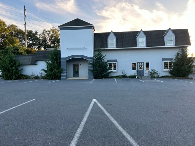

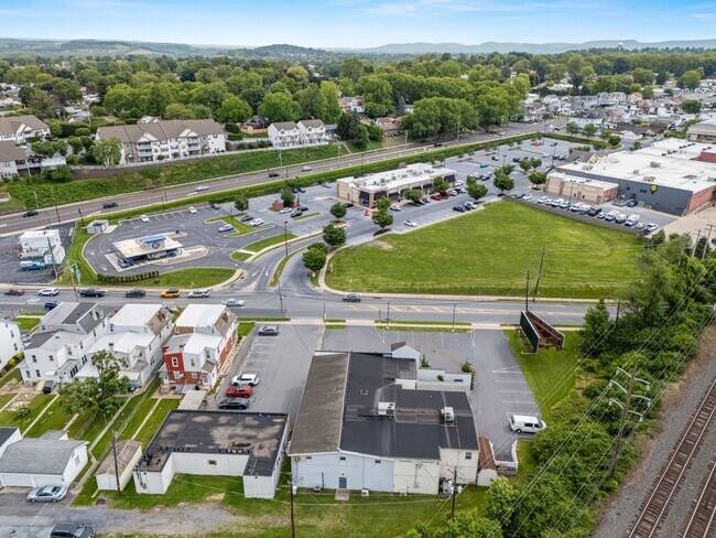
Property Detail
60 Shillington Rd
79-4386-10-35-7623
BERKS
Storesoffices
Pennsylvania
B and X Area of moderate flood hazard, usually the area between the limits of the 100-year and 500-year floods.
0.51 AC
2025
Berks
2025
Philadelphia
010902
Reading, PA
11,540 SF
NEARBY LISTINGS FOR SALE OR LEASE
-
-
View all Reading listings for sale on LoopNet.com
DEMOGRAPHICS near 60 Shillington Rd
1 mile
3 mile
5 mile
2025 Total Population
12,937
56,101
136,760
2030 Population
13,147
57,368
139,601
Pop Growth 2025-2030
+ 1.62%
+ 2.26%
+ 2.08%
Average Age
41
42
40
2025 Total Households
4,941
22,024
51,788
HH Growth 2025-2030
+ 1.62%
+ 2.31%
+ 2.11%
Median Household Inc
$91,150
$94,554
$68,724
Avg Household Size
2.50
2.50
2.50
2025 Avg HH Vehicles
2.00
2.00
2.00
Median Home Value
$278,626
$298,693
$255,749
Median Year Built
1975
1974
1963
Nearby Places
Map Layers
Map Styles
 Street
 Aerial
Transit
 Traffic
 Biking
Places
Listings with unknown addresses are not visible on the map
- Restaurants
- Banks
- Shops
- Fitness
- Groceries
SALE & LEASE HISTORY
LISTING DATE
SALE/LEASE

Oct 24, 2023
For Sale
May 28, 2025
For Sale
Jun 10, 2024
For Lease
Dec 26, 2024
For Sale
Nearby Properties
Address
Land Use
TOTAL SIZE
Lot Size
Zoning
Address
Land Use
TOTAL SIZE
Lot Size
Zoning
732,361 SF
110.76 AC
Address
Land Use
TOTAL SIZE
Lot Size
Zoning
446,569 SF
81.02 AC
Address
Land Use
TOTAL SIZE
Lot Size
Zoning
291,142 SF
9.53 AC
Address
Land Use
TOTAL SIZE
Lot Size
Zoning
258,113 SF
5.93 AC
Address
Land Use
TOTAL SIZE
Lot Size
Zoning
74,849 SF
7.25 AC
Address
Land Use
TOTAL SIZE
Lot Size
Zoning
103.77 AC
Address
Land Use
TOTAL SIZE
Lot Size
Zoning
164,223 SF
15.25 AC
Address
Land Use
TOTAL SIZE
Lot Size
Zoning
116,510 SF
18.23 AC
Address
Land Use
TOTAL SIZE
Lot Size
Zoning
129,035 SF
7.31 AC
Address
Land Use
TOTAL SIZE
Lot Size
Zoning
130,410 SF
23.02 AC
Address
Land Use
TOTAL SIZE
Lot Size
Zoning
76,559 SF
13.52 AC
Address
Land Use
TOTAL SIZE
Lot Size
Zoning
50,507 SF
15.77 AC
Address
Land Use
TOTAL SIZE
Lot Size
Zoning
51,083 SF
3.26 AC
Address
Land Use
TOTAL SIZE
Lot Size
Zoning
117,267 SF
17.45 AC
Address
Land Use
TOTAL SIZE
Lot Size
Zoning
79,475 SF
45.98 AC
Address
Land Use
TOTAL SIZE
Lot Size
Zoning
66,610 SF
5.38 AC
Address
Land Use
TOTAL SIZE
Lot Size
Zoning
107,379 SF
3.30 AC
Address
Land Use
TOTAL SIZE
Lot Size
Zoning
21,714 SF
17.74 AC
Address
Land Use
TOTAL SIZE
Lot Size
Zoning
24,245 SF
4 AC
Address
Land Use
TOTAL SIZE
Lot Size
Zoning
81,892 SF
2.61 AC
Address
Land Use
TOTAL SIZE
Lot Size
Zoning
30,384 SF
2.95 AC
Address
Land Use
TOTAL SIZE
Lot Size
Zoning
125,406 SF
14.35 AC
Address
Land Use
TOTAL SIZE
Lot Size
Zoning
37,960 SF
21.97 AC
Address
Land Use
TOTAL SIZE
Lot Size
Zoning
134,117 SF
12.47 AC
Address
Land Use
TOTAL SIZE
Lot Size
Zoning
39,525 SF
4.99 AC
Address
Land Use
TOTAL SIZE
Lot Size
Zoning
27,204 SF
Address
Land Use
TOTAL SIZE
Lot Size
Zoning
160,194 SF
9.97 AC
Address
Land Use
TOTAL SIZE
Lot Size
Zoning
78,011 SF
12.42 AC
Address
Land Use
TOTAL SIZE
Lot Size
Zoning
33,328 SF
4.69 AC
Address
Land Use
TOTAL SIZE
Lot Size
Zoning
191,244 SF
9.07 AC
The World's #1 Commercial Real Estate Marketplace
Connect with us
© 2026 CoStar Group
The information above has been obtained from sources believed reliable. While we do not doubt its accuracy we have not verified it and make no guarantee, warranty or representation about it. It is your responsibility to independently confirm its accuracy and completeness. Any projections, opinions, assumptions, or estimates used are for example only and do not represent the current or future performance of the property. The value of this transaction to you depends on tax and other factors which should be evaluated by your tax, financial, and legal advisors. You and your advisors should conduct a careful, independent investigation of the property to determine to your satisfaction the suitability of the property for your needs.