Property Record
Stanley St, Dorchester, MA 02125
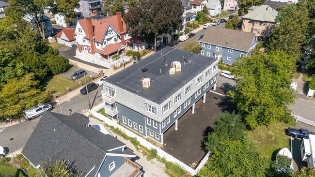

This Property Is For Sale
NEARBY LISTINGS FOR SALE OR LEASE
Property Detail
Stanley St
DORC-000000-000015-001962
Suffolk
Residentialacreage
Massachusetts
X
0.09 AC
25025C0087G
Bowdoin North-Mount Bowdoin
2025
Boston
2025
Boston-Cambridge-Newton, MA-NH
091200
DEMOGRAPHICS near Stanley St
1 Mile
3 Mile
5 Mile
2024 Total Population
68,060
401,371
821,967
2029 Population
68,804
411,236
844,599
Pop Growth 2024-2029
+ 1.09%
+ 2.46%
+ 2.75%
Average Age
38
38
38
2024 Total Households
23,507
161,584
341,019
HH Growth 2024-2029
+ 1.06%
+ 2.67%
+ 3.05%
Median Household Inc
$59,440
$88,766
$104,826
Avg Household Size
2.70
2.20
2.20
2024 Avg HH Vehicles
1.00
1.00
1.00
Median Home Value
$665,292
$777,431
$821,094
Median Year Built
1947
1950
1950
Nearby Places
Map Layers
Map Styles
 Street
 Aerial
- Restaurants
- Banks
- Shops
- Fitness
- Groceries
PUBLIC TRANSPORTATION
TRANSIT/SUBWAY
Uphams Corner (Fairmount Line - Massachusetts Bay Transportation Authority Commuter Rail (Purple Line))
DRIVE
WALK
Distance
Uphams Corner (Fairmount Line - Massachusetts Bay Transportation Authority Commuter Rail (Purple Line))
3 min
18 min
0.9 mi
Fields Corner Station (Red Line - Massachusetts Bay Transportation Authority Subway (The T))
DRIVE
WALK
Distance
Fields Corner Station (Red Line - Massachusetts Bay Transportation Authority Subway (The T))
4 min
20 min
1.0 mi
COMMUTER RAIL
DRIVE
WALK
Distance
3 min
16 min
0.8 mi
Uphams Corner (Fairmount Line - Massachusetts Bay Transportation Authority Commuter Rail (Purple Line))
DRIVE
WALK
Distance
Uphams Corner (Fairmount Line - Massachusetts Bay Transportation Authority Commuter Rail (Purple Line))
3 min
16 min
0.8 mi
AIRPORT
General Edward Lawrence Logan International
DRIVE
WALK
Distance
General Edward Lawrence Logan International
16 min
7.4 mi
Freight Ports
Port of Boston
DRIVE
WALK
Distance
Port of Boston
12 min
4.6 mi
Nearby Properties
Address
Land Use
TOTAL SIZE
Lot Size
Zoning
Address
Land Use
TOTAL SIZE
Lot Size
Zoning
909,764 SF
25.13 AC
E
Address
Land Use
TOTAL SIZE
Lot Size
Zoning
610,560 SF
4.01 AC
E
Address
Land Use
TOTAL SIZE
Lot Size
Zoning
596,972 SF
7.32 AC
E
Address
Land Use
TOTAL SIZE
Lot Size
Zoning
334,522 SF
1.26 AC
C
Address
Land Use
TOTAL SIZE
Lot Size
Zoning
46,259 SF
1.05 AC
E
Address
Land Use
TOTAL SIZE
Lot Size
Zoning
118,759 SF
0.92 AC
C
Address
Land Use
TOTAL SIZE
Lot Size
Zoning
377,634 SF
4.86 AC
E
Address
Land Use
TOTAL SIZE
Lot Size
Zoning
227,107 SF
7.70 AC
E
Address
Land Use
TOTAL SIZE
Lot Size
Zoning
448,796 SF
1.84 AC
C
Address
Land Use
TOTAL SIZE
Lot Size
Zoning
254,208 SF
3.83 AC
E
Address
Land Use
TOTAL SIZE
Lot Size
Zoning
252,392 SF
0.52 AC
C
Address
Land Use
TOTAL SIZE
Lot Size
Zoning
262,120 SF
0.62 AC
C
Address
Land Use
TOTAL SIZE
Lot Size
Zoning
619,050 SF
0.45 AC
C
Address
Land Use
TOTAL SIZE
Lot Size
Zoning
259,990 SF
2.84 AC
E
Address
Land Use
TOTAL SIZE
Lot Size
Zoning
547,851 SF
8.14 AC
E
Address
Land Use
TOTAL SIZE
Lot Size
Zoning
305,455 SF
0.54 AC
RC
Address
Land Use
TOTAL SIZE
Lot Size
Zoning
138,316 SF
0.19 AC
RC
Address
Land Use
TOTAL SIZE
Lot Size
Zoning
157,083 SF
0.41 AC
C
Address
Land Use
TOTAL SIZE
Lot Size
Zoning
303,055 SF
2.15 AC
RC
Address
Land Use
TOTAL SIZE
Lot Size
Zoning
269,232 SF
0.46 AC
C
Address
Land Use
TOTAL SIZE
Lot Size
Zoning
259,607 SF
2.53 AC
A
Address
Land Use
TOTAL SIZE
Lot Size
Zoning
468,308 SF
0.78 AC
E
Address
Land Use
TOTAL SIZE
Lot Size
Zoning
443,356 SF
2.40 AC
C
Address
Land Use
TOTAL SIZE
Lot Size
Zoning
249,135 SF
1.99 AC
RC
Address
Land Use
TOTAL SIZE
Lot Size
Zoning
873,760 SF
38.08 AC
C
Address
Land Use
TOTAL SIZE
Lot Size
Zoning
514,080 SF
0.20 AC
E
Address
Land Use
TOTAL SIZE
Lot Size
Zoning
191,648 SF
0.65 AC
RC
Address
Land Use
TOTAL SIZE
Lot Size
Zoning
522,465 SF
5.34 AC
E
Address
Land Use
TOTAL SIZE
Lot Size
Zoning
76,658 SF
0.38 AC
E
Address
Land Use
TOTAL SIZE
Lot Size
Zoning
281,800 SF
1.17 AC
C
The World's #1 Commercial Real Estate Marketplace
Connect with us
© 2025 CoStar Group
The information above has been obtained from sources believed reliable. While we do not doubt its accuracy we have not verified it and make no guarantee, warranty or representation about it. It is your responsibility to independently confirm its accuracy and completeness. Any projections, opinions, assumptions, or estimates used are for example only and do not represent the current or future performance of the property. The value of this transaction to you depends on tax and other factors which should be evaluated by your tax, financial, and legal advisors. You and your advisors should conduct a careful, independent investigation of the property to determine to your satisfaction the suitability of the property for your needs.