Property Record
60 Unassigned, Vero Beach, FL 32966

NEARBY LISTINGS FOR SALE OR LEASE
Property Detail
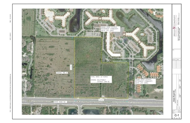
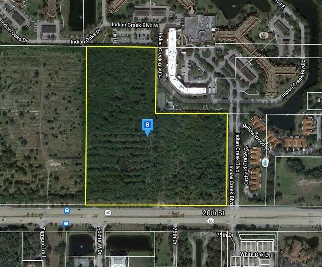
60 Unassigned
33-38-01-00001-0070-00001.1
Indian River Farms Company S/D
Multifamilydwelling
INDIAN RIVER FARMS COMPANY S/D PBS 2-25 SEC 1 TWN 33 RNG 38 TR 7 THE E 13.77 AC OF TR 7 TOGETHER WITH THE W 531.1 FT OF TR 8 LESS AND EXCEPT RD ROW ALSO DESC AS A POR OF TR 7 AND 8 SEC 1 BEG AT THE NE COR OF SAID TR 7 TH S00-12-01W AL THE E LINE OF S
X
Indian River
12061C0238J
Florida
2025
21.99 AC
2025
Fort Pierce/Port St Lucie
050709
Other Market Areas
1,944 SF
Sebastian-Vero Beach, FL
DEMOGRAPHICS near 60 Unassigned
1 Mile
3 Mile
5 Mile
2024 Total Population
6,900
21,895
52,679
2029 Population
7,737
24,541
58,647
Pop Growth 2024-2029
+ 12.13%
+ 12.08%
+ 11.33%
Average Age
60
55
49
2024 Total Households
3,851
10,774
23,279
HH Growth 2024-2029
+ 11.66%
+ 11.69%
+ 10.93%
Median Household Inc
$64,210
$56,287
$57,580
Avg Household Size
1.80
2.00
2.20
2024 Avg HH Vehicles
1.00
2.00
2.00
Median Home Value
$222,311
$235,613
$266,393
Median Year Built
1992
1993
1990
Nearby Places
Map Layers
Map Styles
 Street
 Aerial
- Restaurants
- Banks
- Shops
- Fitness
- Groceries
SALE & LEASE HISTORY
LISTING DATE
SALE/LEASE

Sep 24, 2016
For Sale
Oct 19, 2017
For Sale
Feb 20, 2019
For Sale
Nearby Properties
Address
Land Use
TOTAL SIZE
Lot Size
Zoning
Address
Land Use
TOTAL SIZE
Lot Size
Zoning
223,614 SF
38.25 AC
RM-8
Address
Land Use
TOTAL SIZE
Lot Size
Zoning
83,174 SF
49.75 AC
PD
Address
Land Use
TOTAL SIZE
Lot Size
Zoning
2,391 SF
44.51 AC
CG
Address
Land Use
TOTAL SIZE
Lot Size
Zoning
204,103 SF
33.89 AC
RM-8
Address
Land Use
TOTAL SIZE
Lot Size
Zoning
27.70 AC
RS-6
Address
Land Use
TOTAL SIZE
Lot Size
Zoning
6,532 SF
21.92 AC
RM-6
Address
Land Use
TOTAL SIZE
Lot Size
Zoning
204,713 SF
10.56 AC
PDMXD
Address
Land Use
TOTAL SIZE
Lot Size
Zoning
408,898 SF
78.81 AC
CG
Address
Land Use
TOTAL SIZE
Lot Size
Zoning
241,529 SF
29.18 AC
RM-8
Address
Land Use
TOTAL SIZE
Lot Size
Zoning
83,300 SF
84.34 AC
A-1
Address
Land Use
TOTAL SIZE
Lot Size
Zoning
153,530 SF
17.40 AC
CG
Address
Land Use
TOTAL SIZE
Lot Size
Zoning
298,394 SF
14 AC
RM-6
Address
Land Use
TOTAL SIZE
Lot Size
Zoning
351 SF
11.09 AC
CG
Address
Land Use
TOTAL SIZE
Lot Size
Zoning
81,567 SF
35.55 AC
A-1
Address
Land Use
TOTAL SIZE
Lot Size
Zoning
206,738 SF
17.76 AC
PD
Address
Land Use
TOTAL SIZE
Lot Size
Zoning
180,092 SF
14.66 AC
RM-8
Address
Land Use
TOTAL SIZE
Lot Size
Zoning
102,808 SF
12.51 AC
CG
Address
Land Use
TOTAL SIZE
Lot Size
Zoning
178,300 SF
5.69 AC
PDTND
Address
Land Use
TOTAL SIZE
Lot Size
Zoning
132,186 SF
14.66 AC
CG
Address
Land Use
TOTAL SIZE
Lot Size
Zoning
181,621 SF
28.49 AC
RM-6
Address
Land Use
TOTAL SIZE
Lot Size
Zoning
144,137 SF
14.63 AC
PD
Address
Land Use
TOTAL SIZE
Lot Size
Zoning
23,607 SF
39.05 AC
IL
Address
Land Use
TOTAL SIZE
Lot Size
Zoning
37,060 SF
24 AC
RM-6
Address
Land Use
TOTAL SIZE
Lot Size
Zoning
1,875 SF
8.92 AC
CG
Address
Land Use
TOTAL SIZE
Lot Size
Zoning
95,845 SF
10 AC
RM-8
Address
Land Use
TOTAL SIZE
Lot Size
Zoning
159,400 SF
13.36 AC
CG
Address
Land Use
TOTAL SIZE
Lot Size
Zoning
69,815 SF
3.28 AC
PDTND
Address
Land Use
TOTAL SIZE
Lot Size
Zoning
23,022 SF
59.40 AC
A-1
Address
Land Use
TOTAL SIZE
Lot Size
Zoning
42,625 SF
17.40 AC
RS-3
The World's #1 Commercial Real Estate Marketplace
Connect with us
© 2025 CoStar Group
The information above has been obtained from sources believed reliable. While we do not doubt its accuracy we have not verified it and make no guarantee, warranty or representation about it. It is your responsibility to independently confirm its accuracy and completeness. Any projections, opinions, assumptions, or estimates used are for example only and do not represent the current or future performance of the property. The value of this transaction to you depends on tax and other factors which should be evaluated by your tax, financial, and legal advisors. You and your advisors should conduct a careful, independent investigation of the property to determine to your satisfaction the suitability of the property for your needs.