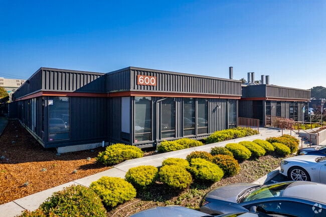
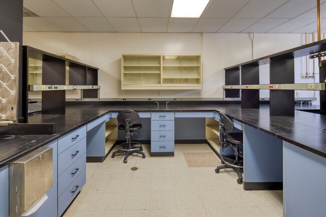
Property Record
600 Bancroft Way, Berkeley, CA 94710

Current Lease Availabilities
Property Detail
600 Bancroft Way
056-1949-007-00
LOT: 0000A BLK: PM: 0061 PAGE: 0007 ;LOT: 0000B BLK: PM: 0061 PAGE: 0007
Scientificpharmaceuticalmedicalresearchfacility
ALAMEDA
AE The base floodplain where base flood elevations are provided. AE Zones are now used on new format FIRMs instead of A1-A30 Zones.
California
2024
1.50 AC
2025
Berkeley
422000
East Bay/Oakland
23,088 SF
Oakland-Fremont-Berkeley, CA
NEARBY LISTINGS FOR SALE OR LEASE
DEMOGRAPHICS near 600 Bancroft Way
1 mile
3 mile
5 mile
2025 Total Population
16,777
196,486
382,085
2030 Population
16,741
197,060
384,497
Pop Growth 2025-2030
(0.21%)
+ 0.29%
+ 0.63%
Average Age
41
39
41
2025 Total Households
6,825
78,750
160,640
HH Growth 2025-2030
(0.35%)
+ 0.39%
+ 0.74%
Median Household Inc
$95,523
$107,686
$111,509
Avg Household Size
2.20
2.20
2.20
2025 Avg HH Vehicles
1.00
1.00
1.00
Median Home Value
$1,080,769
$1,076,621
$1,058,875
Median Year Built
1957
1950
1958
Nearby Places
Map Layers
Map Styles
 Street
 Aerial
Layers
 Traffic
 Biking
Places
Listings with unknown addresses are not visible on the map
- Restaurants
- Banks
- Shops
- Fitness
- Groceries
PUBLIC TRANSPORTATION
COMMUTER RAIL
Berkeley Amtrak (Capitol Corridor - Amtrak)
Drive
Walk
Distance
Berkeley Amtrak (Capitol Corridor - Amtrak)
3 min
8 min
0.4 mi
Emeryville (Capitol Corridor - Capitol Corridor Joint Powers Authority)
Drive
Walk
Distance
Emeryville (Capitol Corridor - Capitol Corridor Joint Powers Authority)
6 min
2.0 mi
AIRPORT
Metro Oakland International
Drive
Walk
Distance
Metro Oakland International
25 min
16.3 mi
San Francisco International
Drive
Walk
Distance
San Francisco International
37 min
23.9 mi
Freight Ports
Port of Richmond
Drive
Walk
Distance
Port of Richmond
17 min
10.3 mi
Nearby Properties
Address
Land Use
TOTAL SIZE
Lot Size
Zoning
Address
Land Use
TOTAL SIZE
Lot Size
Zoning
373,594 SF
16.16 AC
Address
Land Use
TOTAL SIZE
Lot Size
Zoning
354,263 SF
4.06 AC
Address
Land Use
TOTAL SIZE
Lot Size
Zoning
358,014 SF
5.03 AC
Address
Land Use
TOTAL SIZE
Lot Size
Zoning
167,071 SF
0.70 AC
Address
Land Use
TOTAL SIZE
Lot Size
Zoning
540,434 SF
14.37 AC
Address
Land Use
TOTAL SIZE
Lot Size
Zoning
395,549 SF
17.05 AC
Address
Land Use
TOTAL SIZE
Lot Size
Zoning
240,633 SF
1.59 AC
Address
Land Use
TOTAL SIZE
Lot Size
Zoning
261,134 SF
2.23 AC
Address
Land Use
TOTAL SIZE
Lot Size
Zoning
169,157 SF
10.20 AC
Address
Land Use
TOTAL SIZE
Lot Size
Zoning
224,160 SF
5.03 AC
Address
Land Use
TOTAL SIZE
Lot Size
Zoning
226,800 SF
4.63 AC
Address
Land Use
TOTAL SIZE
Lot Size
Zoning
370,806 SF
2.24 AC
Address
Land Use
TOTAL SIZE
Lot Size
Zoning
4.77 AC
Address
Land Use
TOTAL SIZE
Lot Size
Zoning
292,430 SF
2.09 AC
Address
Land Use
TOTAL SIZE
Lot Size
Zoning
397,378 SF
4.52 AC
Address
Land Use
TOTAL SIZE
Lot Size
Zoning
309,451 SF
0.87 AC
Address
Land Use
TOTAL SIZE
Lot Size
Zoning
2.29 AC
Address
Land Use
TOTAL SIZE
Lot Size
Zoning
238,118 SF
2.14 AC
Address
Land Use
TOTAL SIZE
Lot Size
Zoning
60,670 SF
1.57 AC
Address
Land Use
TOTAL SIZE
Lot Size
Zoning
196,209 SF
3.14 AC
Address
Land Use
TOTAL SIZE
Lot Size
Zoning
123,750 SF
0.81 AC
Address
Land Use
TOTAL SIZE
Lot Size
Zoning
270,667 SF
2.76 AC
Address
Land Use
TOTAL SIZE
Lot Size
Zoning
254,000 SF
1.71 AC
Address
Land Use
TOTAL SIZE
Lot Size
Zoning
127,260 SF
5 AC
I
Address
Land Use
TOTAL SIZE
Lot Size
Zoning
2.65 AC
Address
Land Use
TOTAL SIZE
Lot Size
Zoning
203,859 SF
2.35 AC
Address
Land Use
TOTAL SIZE
Lot Size
Zoning
250,152 SF
9.26 AC
Address
Land Use
TOTAL SIZE
Lot Size
Zoning
166,731 SF
0.54 AC
Address
Land Use
TOTAL SIZE
Lot Size
Zoning
180,977 SF
1.21 AC
Address
Land Use
TOTAL SIZE
Lot Size
Zoning
86,144 SF
0.52 AC
The World's #1 Commercial Real Estate Marketplace
Connect with us
© 2026 CoStar Group
The information above has been obtained from sources believed reliable. While we do not doubt its accuracy we have not verified it and make no guarantee, warranty or representation about it. It is your responsibility to independently confirm its accuracy and completeness. Any projections, opinions, assumptions, or estimates used are for example only and do not represent the current or future performance of the property. The value of this transaction to you depends on tax and other factors which should be evaluated by your tax, financial, and legal advisors. You and your advisors should conduct a careful, independent investigation of the property to determine to your satisfaction the suitability of the property for your needs.