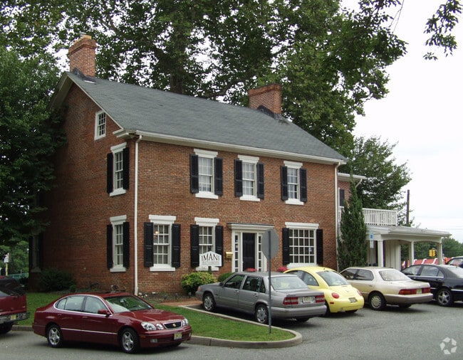
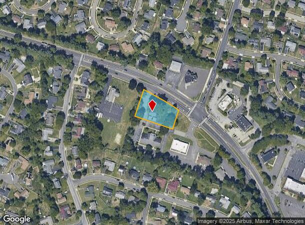
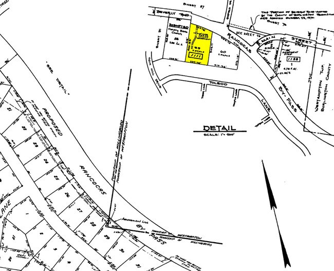
Property Record
600 Beverly Rancocas Rd, Willingboro, NJ 08046
NEARBY LISTINGS FOR SALE OR LEASE
Property Detail
600 Beverly Rancocas Rd
Philadelphia-Camden-Wilmington, PA-NJ-DE-MD
ADDITIONAL LOTS: 300OB
38-01111-0000-00059-01
Burlington
Commercialnec
New Jersey
X
59.1
34005C0119F
0.81 AC
2024
North Burlington County
2025
Philadelphia
702805
DEMOGRAPHICS near 600 Beverly Rancocas Rd
1 Mile
3 Mile
5 Mile
2024 Total Population
10,022
60,241
159,260
2029 Population
10,189
61,324
162,238
Pop Growth 2024-2029
+ 1.67%
+ 1.80%
+ 1.87%
Average Age
44
42
41
2024 Total Households
3,563
22,319
60,092
HH Growth 2024-2029
+ 1.71%
+ 1.78%
+ 1.85%
Median Household Inc
$96,053
$94,542
$93,437
Avg Household Size
2.70
2.60
2.60
2024 Avg HH Vehicles
2.00
2.00
2.00
Median Home Value
$227,318
$235,669
$262,113
Median Year Built
1963
1969
1971
Nearby Places
Map Layers
Map Styles
 Street
 Aerial
- Restaurants
- Banks
- Shops
- Fitness
- Groceries
PUBLIC TRANSPORTATION
COMMUTER RAIL
Bristol (R7 - Southeastern Pennsylvania Transportation Authority Regional Rail (SEPTA Regional Rail))
DRIVE
WALK
Distance
Bristol (R7 - Southeastern Pennsylvania Transportation Authority Regional Rail (SEPTA Regional Rail))
18 min
9.4 mi
Croydon (R7 - Southeastern Pennsylvania Transportation Authority Regional Rail (SEPTA Regional Rail))
DRIVE
WALK
Distance
Croydon (R7 - Southeastern Pennsylvania Transportation Authority Regional Rail (SEPTA Regional Rail))
19 min
9.9 mi
AIRPORT
Trenton Mercer
DRIVE
WALK
Distance
Trenton Mercer
40 min
27.0 mi
Philadelphia International
DRIVE
WALK
Distance
Philadelphia International
43 min
28.3 mi
Nearby Properties
Address
Land Use
TOTAL SIZE
Lot Size
Zoning
Address
Land Use
TOTAL SIZE
Lot Size
Zoning
39.18 AC
Address
Land Use
TOTAL SIZE
Lot Size
Zoning
86.67 AC
R-5
Address
Land Use
TOTAL SIZE
Lot Size
Zoning
14.82 AC
Address
Land Use
TOTAL SIZE
Lot Size
Zoning
14.15 AC
Address
Land Use
TOTAL SIZE
Lot Size
Zoning
97,993 SF
63.75 AC
Address
Land Use
TOTAL SIZE
Lot Size
Zoning
30.76 AC
R-9
Address
Land Use
TOTAL SIZE
Lot Size
Zoning
25.58 AC
Address
Land Use
TOTAL SIZE
Lot Size
Zoning
999,999,999 SF
88.63 AC
Address
Land Use
TOTAL SIZE
Lot Size
Zoning
8.31 AC
Address
Land Use
TOTAL SIZE
Lot Size
Zoning
682,707 SF
Address
Land Use
TOTAL SIZE
Lot Size
Zoning
Address
Land Use
TOTAL SIZE
Lot Size
Zoning
Address
Land Use
TOTAL SIZE
Lot Size
Zoning
Address
Land Use
TOTAL SIZE
Lot Size
Zoning
376 SF
32.32 AC
B-3
Address
Land Use
TOTAL SIZE
Lot Size
Zoning
2,704 SF
28.75 AC
Address
Land Use
TOTAL SIZE
Lot Size
Zoning
Address
Land Use
TOTAL SIZE
Lot Size
Zoning
15.09 AC
Address
Land Use
TOTAL SIZE
Lot Size
Zoning
190,000 SF
22.17 AC
Address
Land Use
TOTAL SIZE
Lot Size
Zoning
266,966 SF
39.90 AC
I-1
Address
Land Use
TOTAL SIZE
Lot Size
Zoning
217,986 SF
39.89 AC
I-1
Address
Land Use
TOTAL SIZE
Lot Size
Zoning
9.65 AC
Address
Land Use
TOTAL SIZE
Lot Size
Zoning
Address
Land Use
TOTAL SIZE
Lot Size
Zoning
45.64 AC
Address
Land Use
TOTAL SIZE
Lot Size
Zoning
10.21 AC
FRMX
Address
Land Use
TOTAL SIZE
Lot Size
Zoning
302,372 SF
15.05 AC
Address
Land Use
TOTAL SIZE
Lot Size
Zoning
Address
Land Use
TOTAL SIZE
Lot Size
Zoning
372,324 SF
17 AC
Address
Land Use
TOTAL SIZE
Lot Size
Zoning
276 SF
14.37 AC
R-12
Address
Land Use
TOTAL SIZE
Lot Size
Zoning
17.63 AC
R-1
Address
Land Use
TOTAL SIZE
Lot Size
Zoning
300,609 SF
16.07 AC
I
The World's #1 Commercial Real Estate Marketplace
Connect with us
© 2025 CoStar Group
The information above has been obtained from sources believed reliable. While we do not doubt its accuracy we have not verified it and make no guarantee, warranty or representation about it. It is your responsibility to independently confirm its accuracy and completeness. Any projections, opinions, assumptions, or estimates used are for example only and do not represent the current or future performance of the property. The value of this transaction to you depends on tax and other factors which should be evaluated by your tax, financial, and legal advisors. You and your advisors should conduct a careful, independent investigation of the property to determine to your satisfaction the suitability of the property for your needs.