Property Record
600 Buck Rd, Monroeville, NJ 08343

NEARBY LISTINGS FOR SALE OR LEASE
-
-
View all Monroeville listings for sale on LoopNet.com
Property Detail
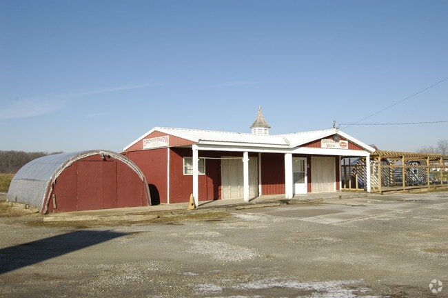
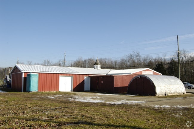
600 Buck Rd
04-00177-0000-00002-01
ADDITIONAL LOTS MINI MART/GAS STA
Servicestation
Gloucester
X
New Jersey
34015C0213E
2.1
2024
3.63 AC
2025
Gloucester County
501900
Philadelphia
3,870 SF
Philadelphia-Camden-Wilmington, PA-NJ-DE-MD
DEMOGRAPHICS near 600 Buck Rd
1 Mile
3 Mile
5 Mile
2024 Total Population
1,037
14,675
58,529
2029 Population
1,075
15,175
60,482
Pop Growth 2024-2029
+ 3.66%
+ 3.41%
+ 3.34%
Average Age
42
41
38
2024 Total Households
353
5,328
19,540
HH Growth 2024-2029
+ 3.68%
+ 3.45%
+ 3.62%
Median Household Inc
$134,895
$93,276
$91,945
Avg Household Size
2.80
2.70
2.60
2024 Avg HH Vehicles
3.00
2.00
2.00
Median Home Value
$327,778
$242,049
$261,828
Median Year Built
1977
1980
1980
Nearby Places
Map Layers
Map Styles
 Street
 Aerial
- Restaurants
- Banks
- Shops
- Fitness
- Groceries
PUBLIC TRANSPORTATION
AIRPORT
Philadelphia International
DRIVE
WALK
Distance
Philadelphia International
43 min
28.9 mi
Freight Ports
Broadway Terminal - Pier 5
DRIVE
WALK
Distance
Broadway Terminal - Pier 5
27 min
20.4 mi
Nearby Properties
Address
Land Use
TOTAL SIZE
Lot Size
Zoning
Address
Land Use
TOTAL SIZE
Lot Size
Zoning
23.80 AC
R-B
Address
Land Use
TOTAL SIZE
Lot Size
Zoning
37.40 AC
CF/I
Address
Land Use
TOTAL SIZE
Lot Size
Zoning
17.02 AC
PA
Address
Land Use
TOTAL SIZE
Lot Size
Zoning
21.14 AC
CF/I
Address
Land Use
TOTAL SIZE
Lot Size
Zoning
76.57 AC
I
Address
Land Use
TOTAL SIZE
Lot Size
Zoning
15.47 AC
C5
Address
Land Use
TOTAL SIZE
Lot Size
Zoning
39.31 AC
I2
Address
Land Use
TOTAL SIZE
Lot Size
Zoning
55.88 AC
APA
Address
Land Use
TOTAL SIZE
Lot Size
Zoning
17.78 AC
I2
Address
Land Use
TOTAL SIZE
Lot Size
Zoning
3,750 SF
5.55 AC
C3
Address
Land Use
TOTAL SIZE
Lot Size
Zoning
7.61 AC
APA
Address
Land Use
TOTAL SIZE
Lot Size
Zoning
18,135 SF
6.06 AC
RE
Address
Land Use
TOTAL SIZE
Lot Size
Zoning
469 AC
CF/I
Address
Land Use
TOTAL SIZE
Lot Size
Zoning
13,534 SF
5 AC
RE
Address
Land Use
TOTAL SIZE
Lot Size
Zoning
19.41 AC
I2
Address
Land Use
TOTAL SIZE
Lot Size
Zoning
1.99 AC
CO
Address
Land Use
TOTAL SIZE
Lot Size
Zoning
5.71 AC
C4
Address
Land Use
TOTAL SIZE
Lot Size
Zoning
4.75 AC
I2
Address
Land Use
TOTAL SIZE
Lot Size
Zoning
1.99 AC
I
Address
Land Use
TOTAL SIZE
Lot Size
Zoning
10,296 SF
26.87 AC
C4
Address
Land Use
TOTAL SIZE
Lot Size
Zoning
1,669 SF
3.13 AC
C-1
Address
Land Use
TOTAL SIZE
Lot Size
Zoning
5.68 AC
R5
Address
Land Use
TOTAL SIZE
Lot Size
Zoning
4,096 SF
8.86 AC
CO
Address
Land Use
TOTAL SIZE
Lot Size
Zoning
148.41 AC
P
Address
Land Use
TOTAL SIZE
Lot Size
Zoning
36.54 AC
P
Address
Land Use
TOTAL SIZE
Lot Size
Zoning
1,495 SF
2.01 AC
CO
Address
Land Use
TOTAL SIZE
Lot Size
Zoning
8.62 AC
C5
Address
Land Use
TOTAL SIZE
Lot Size
Zoning
3.13 AC
P
Address
Land Use
TOTAL SIZE
Lot Size
Zoning
8,848 SF
1.33 AC
C1
Address
Land Use
TOTAL SIZE
Lot Size
Zoning
1.03 AC
R2
The World's #1 Commercial Real Estate Marketplace
Connect with us
© 2026 CoStar Group
The information above has been obtained from sources believed reliable. While we do not doubt its accuracy we have not verified it and make no guarantee, warranty or representation about it. It is your responsibility to independently confirm its accuracy and completeness. Any projections, opinions, assumptions, or estimates used are for example only and do not represent the current or future performance of the property. The value of this transaction to you depends on tax and other factors which should be evaluated by your tax, financial, and legal advisors. You and your advisors should conduct a careful, independent investigation of the property to determine to your satisfaction the suitability of the property for your needs.