Property Record
600 E 107Th St, Bolingbrook, IL 60440
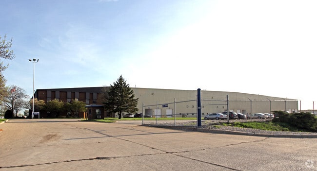

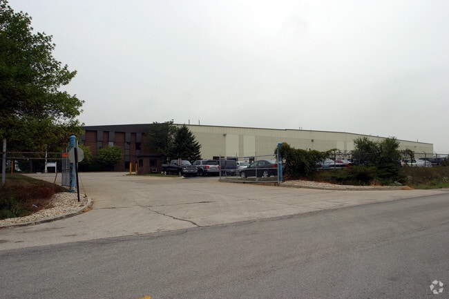
Property Detail
600 E 107Th St
Chicago-Naperville-Elgin, IL-IN
LOT 3 IN MARMON/KEYSTONE SUB, BEING A SUB OF PRT OF THE N1/2 OF SEC 13, T37N-R10E.
12-02-13-107-003
WILL
Industrialgeneral
Illinois
B and X Area of moderate flood hazard, usually the area between the limits of the 100-year and 500-year floods.
3
2025
19.22 AC
2024
South I-55 Corridor
880107
Chicago
372,304 SF
NEARBY LISTINGS FOR SALE OR LEASE
DEMOGRAPHICS near 600 E 107Th St
1 mile
3 mile
5 mile
2025 Total Population
5,336
57,605
164,774
2030 Population
5,330
57,981
166,684
Pop Growth 2025-2030
(0.11%)
+ 0.65%
+ 1.16%
Average Age
37
40
41
2025 Total Households
1,621
19,971
58,599
HH Growth 2025-2030
(0.25%)
+ 0.72%
+ 1.18%
Median Household Inc
$82,562
$97,094
$103,586
Avg Household Size
3.20
2.80
2.70
2025 Avg HH Vehicles
2.00
2.00
2.00
Median Home Value
$258,682
$298,078
$348,936
Median Year Built
1970
1978
1981
Nearby Places
Map Layers
Map Styles
 Street
 Aerial
Layers
 Traffic
 Biking
Places
Listings with unknown addresses are not visible on the map
- Restaurants
- Banks
- Shops
- Fitness
- Groceries
PUBLIC TRANSPORTATION
COMMUTER RAIL
Lemont Station (Heritage Corridor Line - Northeast Illinois Regional Commuter Railroad (Metra))
Drive
Walk
Distance
Lemont Station (Heritage Corridor Line - Northeast Illinois Regional Commuter Railroad (Metra))
9 min
5.5 mi
Romeoville (Heritage Corridor - Metra)
Drive
Walk
Distance
Romeoville (Heritage Corridor - Metra)
12 min
7.1 mi
AIRPORT
Chicago Midway International
Drive
Walk
Distance
Chicago Midway International
24 min
17.5 mi
Chicago O'Hare International
Drive
Walk
Distance
Chicago O'Hare International
41 min
28.9 mi
Freight Ports
Port Milwaukee
Drive
Walk
Distance
Port Milwaukee
122 min
100.7 mi
Nearby Properties
Address
Land Use
TOTAL SIZE
Lot Size
Zoning
Address
Land Use
TOTAL SIZE
Lot Size
Zoning
32.82 AC
Address
Land Use
TOTAL SIZE
Lot Size
Zoning
21,520 SF
32.67 AC
Address
Land Use
TOTAL SIZE
Lot Size
Zoning
373,827 SF
21.30 AC
Address
Land Use
TOTAL SIZE
Lot Size
Zoning
759,709 SF
41.75 AC
Address
Land Use
TOTAL SIZE
Lot Size
Zoning
21.12 AC
Address
Land Use
TOTAL SIZE
Lot Size
Zoning
48.48 AC
Address
Land Use
TOTAL SIZE
Lot Size
Zoning
22.75 AC
Address
Land Use
TOTAL SIZE
Lot Size
Zoning
49.91 AC
Address
Land Use
TOTAL SIZE
Lot Size
Zoning
334,656 SF
17.72 AC
I
Address
Land Use
TOTAL SIZE
Lot Size
Zoning
9.58 AC
M
Address
Land Use
TOTAL SIZE
Lot Size
Zoning
353,286 SF
19.84 AC
Address
Land Use
TOTAL SIZE
Lot Size
Zoning
28.89 AC
Address
Land Use
TOTAL SIZE
Lot Size
Zoning
264,310 SF
12.21 AC
I
Address
Land Use
TOTAL SIZE
Lot Size
Zoning
12.52 AC
Address
Land Use
TOTAL SIZE
Lot Size
Zoning
581,000 SF
28.56 AC
Address
Land Use
TOTAL SIZE
Lot Size
Zoning
270,372 SF
12.49 AC
Address
Land Use
TOTAL SIZE
Lot Size
Zoning
28.15 AC
Address
Land Use
TOTAL SIZE
Lot Size
Zoning
557,851 SF
25.47 AC
Address
Land Use
TOTAL SIZE
Lot Size
Zoning
513,805 SF
23.84 AC
Address
Land Use
TOTAL SIZE
Lot Size
Zoning
165.89 AC
Address
Land Use
TOTAL SIZE
Lot Size
Zoning
506,726 SF
28.54 AC
Address
Land Use
TOTAL SIZE
Lot Size
Zoning
490,436 SF
22.22 AC
Address
Land Use
TOTAL SIZE
Lot Size
Zoning
500,160 SF
25.07 AC
Address
Land Use
TOTAL SIZE
Lot Size
Zoning
600,566 SF
20.17 AC
Address
Land Use
TOTAL SIZE
Lot Size
Zoning
460,350 SF
23.14 AC
Address
Land Use
TOTAL SIZE
Lot Size
Zoning
458,472 SF
33.64 AC
Address
Land Use
TOTAL SIZE
Lot Size
Zoning
11,250 SF
67.19 AC
Address
Land Use
TOTAL SIZE
Lot Size
Zoning
143,024 SF
21.50 AC
Address
Land Use
TOTAL SIZE
Lot Size
Zoning
499,750 SF
26.72 AC
Address
Land Use
TOTAL SIZE
Lot Size
Zoning
13.42 AC
The World's #1 Commercial Real Estate Marketplace
Connect with us
© 2026 CoStar Group
The information above has been obtained from sources believed reliable. While we do not doubt its accuracy we have not verified it and make no guarantee, warranty or representation about it. It is your responsibility to independently confirm its accuracy and completeness. Any projections, opinions, assumptions, or estimates used are for example only and do not represent the current or future performance of the property. The value of this transaction to you depends on tax and other factors which should be evaluated by your tax, financial, and legal advisors. You and your advisors should conduct a careful, independent investigation of the property to determine to your satisfaction the suitability of the property for your needs.