Property Record
600 E Le Claire Rd, Eldridge, IA 52748
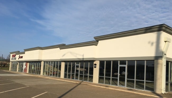

This Property Is For Sale
Current Lease Availabilities
Property Detail
600 E Le Claire Rd
Davenport-Moline-Rock Island, IA-IL
LANCER PARK 6TH ADD REPLAT LOT: 002 LANCER PARK 6TH ADDREPLAT LOT 15(LOTS 1& 2) AND LOT 14LANCER PARK 6TH ADD
9311532021
Scott
Stripcommercialcenter
Iowa
B and X Area of moderate flood hazard, usually the area between the limits of the 100-year and 500-year floods.
1-2,15
2025
2.60 AC
2025
Outlying Scott County
010201
Davenport/Moline/Rock Island
27,040 SF
NEARBY LISTINGS FOR SALE OR LEASE
DEMOGRAPHICS near 600 E Le Claire Rd
1 mile
3 mile
5 mile
2025 Total Population
5,016
8,202
16,771
2030 Population
5,067
8,267
16,887
Pop Growth 2025-2030
+ 1.02%
+ 0.79%
+ 0.69%
Average Age
40
40
39
2025 Total Households
1,988
3,233
6,513
HH Growth 2025-2030
+ 0.96%
+ 0.77%
+ 0.69%
Median Household Inc
$98,614
$98,517
$92,248
Avg Household Size
2.50
2.50
2.50
2025 Avg HH Vehicles
2.00
2.00
2.00
Median Home Value
$395,121
$387,055
$310,986
Median Year Built
1992
1990
1983
Nearby Places
Map Layers
Map Styles
 Street
 Aerial
Layers
 Traffic
 Biking
Places
Listings with unknown addresses are not visible on the map
- Restaurants
- Banks
- Shops
- Fitness
- Groceries
PUBLIC TRANSPORTATION
AIRPORT
Quad Cities International
Drive
Walk
Distance
Quad Cities International
36 min
19.6 mi
Nearby Properties
Address
Land Use
TOTAL SIZE
Lot Size
Zoning
Address
Land Use
TOTAL SIZE
Lot Size
Zoning
26,460 SF
42.72 AC
Address
Land Use
TOTAL SIZE
Lot Size
Zoning
1,440 SF
9.29 AC
Address
Land Use
TOTAL SIZE
Lot Size
Zoning
4,804 SF
202 AC
Address
Land Use
TOTAL SIZE
Lot Size
Zoning
422,688 SF
16.44 AC
Address
Land Use
TOTAL SIZE
Lot Size
Zoning
1,414 SF
8.71 AC
Address
Land Use
TOTAL SIZE
Lot Size
Zoning
387,408 SF
13.68 AC
Address
Land Use
TOTAL SIZE
Lot Size
Zoning
10,980 SF
42.84 AC
Address
Land Use
TOTAL SIZE
Lot Size
Zoning
175,578 SF
17.19 AC
Address
Land Use
TOTAL SIZE
Lot Size
Zoning
113,921 SF
18.78 AC
Address
Land Use
TOTAL SIZE
Lot Size
Zoning
140,242 SF
10.79 AC
Address
Land Use
TOTAL SIZE
Lot Size
Zoning
4,725 SF
45.96 AC
Address
Land Use
TOTAL SIZE
Lot Size
Zoning
35,712 SF
2.09 AC
Address
Land Use
TOTAL SIZE
Lot Size
Zoning
728 SF
5.09 AC
Address
Land Use
TOTAL SIZE
Lot Size
Zoning
9,980 SF
3.12 AC
Address
Land Use
TOTAL SIZE
Lot Size
Zoning
17,844 SF
1.71 AC
Address
Land Use
TOTAL SIZE
Lot Size
Zoning
12,168 SF
1.71 AC
Address
Land Use
TOTAL SIZE
Lot Size
Zoning
62,260 SF
5.65 AC
Address
Land Use
TOTAL SIZE
Lot Size
Zoning
4,560 SF
5.61 AC
Address
Land Use
TOTAL SIZE
Lot Size
Zoning
74,096 SF
11.80 AC
Address
Land Use
TOTAL SIZE
Lot Size
Zoning
15,000 SF
9.12 AC
Address
Land Use
TOTAL SIZE
Lot Size
Zoning
6,120 SF
6.51 AC
Address
Land Use
TOTAL SIZE
Lot Size
Zoning
21,030 SF
3.24 AC
Address
Land Use
TOTAL SIZE
Lot Size
Zoning
14,000 SF
6.11 AC
Address
Land Use
TOTAL SIZE
Lot Size
Zoning
12,912 SF
4.20 AC
Address
Land Use
TOTAL SIZE
Lot Size
Zoning
47,300 SF
3.47 AC
Address
Land Use
TOTAL SIZE
Lot Size
Zoning
3,600 SF
3.17 AC
Address
Land Use
TOTAL SIZE
Lot Size
Zoning
462 SF
19.88 AC
Address
Land Use
TOTAL SIZE
Lot Size
Zoning
19,736 SF
2.58 AC
Address
Land Use
TOTAL SIZE
Lot Size
Zoning
57,122 SF
14.03 AC
CAD
Address
Land Use
TOTAL SIZE
Lot Size
Zoning
9,980 SF
1.67 AC
The World's #1 Commercial Real Estate Marketplace
Connect with us
© 2026 CoStar Group
The information above has been obtained from sources believed reliable. While we do not doubt its accuracy we have not verified it and make no guarantee, warranty or representation about it. It is your responsibility to independently confirm its accuracy and completeness. Any projections, opinions, assumptions, or estimates used are for example only and do not represent the current or future performance of the property. The value of this transaction to you depends on tax and other factors which should be evaluated by your tax, financial, and legal advisors. You and your advisors should conduct a careful, independent investigation of the property to determine to your satisfaction the suitability of the property for your needs.