Property Record
600 E Olive Ave, Burbank, CA 91501
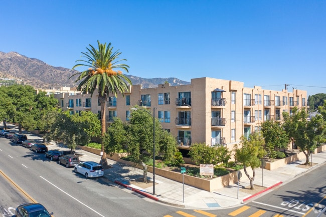


Property Detail
600 E Olive Ave
2455-018-023
BURBANK LOTS 10, 12, 14, 16, 18 AND LOT 20 BLK 25
Multifamilydwelling
Los Angeles
BUR4*
California
B and X Area of moderate flood hazard, usually the area between the limits of the 100-year and 500-year floods.
10
2024
1.07 AC
2025
Burbank
310202
Los Angeles
88,330 SF
Los Angeles-Long Beach-Glendale, CA
NEARBY LISTINGS FOR SALE OR LEASE
DEMOGRAPHICS near 600 E Olive Ave
1 mile
3 mile
5 mile
2025 Total Population
33,688
137,798
454,108
2030 Population
33,307
136,138
449,857
Pop Growth 2025-2030
(1.13%)
(1.20%)
(0.94%)
Average Age
43
43
42
2025 Total Households
13,882
53,642
178,529
HH Growth 2025-2030
(1.35%)
(1.46%)
(1.14%)
Median Household Inc
$77,085
$95,051
$86,400
Avg Household Size
2.40
2.50
2.50
2025 Avg HH Vehicles
2.00
2.00
2.00
Median Home Value
$1,031,479
$1,042,905
$1,006,084
Median Year Built
1972
1958
1964
Nearby Places
Map Layers
Map Styles
 Street
 Aerial
Transit
 Traffic
 Biking
Places
Listings with unknown addresses are not visible on the map
- Restaurants
- Banks
- Shops
- Fitness
- Groceries
PUBLIC TRANSPORTATION
COMMUTER RAIL
Downtown Burbank (Antelope Valley Line - Amtrak, Pacific Surfliner - Amtrak, Ventura County Line - Amtrak)
Drive
Walk
Distance
Downtown Burbank (Antelope Valley Line - Amtrak, Pacific Surfliner - Amtrak, Ventura County Line - Amtrak)
3 min
16 min
0.8 mi
Burbank-Bob Hope Airport (Ventura County Line - Southern California Regional Rail Authority (Metrolink))
Drive
Walk
Distance
Burbank-Bob Hope Airport (Ventura County Line - Southern California Regional Rail Authority (Metrolink))
7 min
3.4 mi
AIRPORT
Bob Hope
Drive
Walk
Distance
Bob Hope
11 min
6.2 mi
Los Angeles International
Drive
Walk
Distance
Los Angeles International
40 min
20.5 mi
Long Beach (Daugherty Field)
Drive
Walk
Distance
Long Beach (Daugherty Field)
45 min
32.5 mi
Freight Ports
Port of Long Beach
Drive
Walk
Distance
Port of Long Beach
47 min
35.3 mi
SALE & LEASE HISTORY
LISTING DATE
SALE/LEASE

Jul 15, 2025
For Sale
Nearby Properties
Address
Land Use
TOTAL SIZE
Lot Size
Zoning
Address
Land Use
TOTAL SIZE
Lot Size
Zoning
735,900 SF
34.87 AC
BUPD*
Address
Land Use
TOTAL SIZE
Lot Size
Zoning
207,766 SF
42.81 AC
BUM1*
Address
Land Use
TOTAL SIZE
Lot Size
Zoning
616,662 SF
19.66 AC
BUM1*
Address
Land Use
TOTAL SIZE
Lot Size
Zoning
359,197 SF
13.49 AC
GLENDALE M
Address
Land Use
TOTAL SIZE
Lot Size
Zoning
397,477 SF
2.75 AC
BUR4
Address
Land Use
TOTAL SIZE
Lot Size
Zoning
979,623 SF
13.36 AC
GLM2
Address
Land Use
TOTAL SIZE
Lot Size
Zoning
489,466 SF
2.90 AC
BUM1
Address
Land Use
TOTAL SIZE
Lot Size
Zoning
452,048 SF
21.58 AC
BCCM
Address
Land Use
TOTAL SIZE
Lot Size
Zoning
43,558 SF
30.11 AC
BUMI-C2*
Address
Land Use
TOTAL SIZE
Lot Size
Zoning
1,328,547 SF
39.36 AC
BUPD
Address
Land Use
TOTAL SIZE
Lot Size
Zoning
432,232 SF
7.17 AC
BUM2
Address
Land Use
TOTAL SIZE
Lot Size
Zoning
219,607 SF
1.51 AC
BUR4
Address
Land Use
TOTAL SIZE
Lot Size
Zoning
380,017 SF
Address
Land Use
TOTAL SIZE
Lot Size
Zoning
362,863 SF
1.82 AC
BUMZ
Address
Land Use
TOTAL SIZE
Lot Size
Zoning
346,186 SF
11.72 AC
BUM2*
Address
Land Use
TOTAL SIZE
Lot Size
Zoning
558,532 SF
5.20 AC
BUC4*
Address
Land Use
TOTAL SIZE
Lot Size
Zoning
660,463 SF
6.88 AC
BUR4*
Address
Land Use
TOTAL SIZE
Lot Size
Zoning
612,976 SF
3.53 AC
BUC2*
Address
Land Use
TOTAL SIZE
Lot Size
Zoning
126,452 SF
9.27 AC
GLM2*
Address
Land Use
TOTAL SIZE
Lot Size
Zoning
151,704 SF
1 AC
BUC4*
Address
Land Use
TOTAL SIZE
Lot Size
Zoning
BURAILROAD
Address
Land Use
TOTAL SIZE
Lot Size
Zoning
488,658 SF
3.85 AC
BUMDCZ*
Address
Land Use
TOTAL SIZE
Lot Size
Zoning
279,574 SF
4.01 AC
BUM2*
Address
Land Use
TOTAL SIZE
Lot Size
Zoning
299,864 SF
1.29 AC
BUC3
Address
Land Use
TOTAL SIZE
Lot Size
Zoning
252,974 SF
2.86 AC
BUC4
Address
Land Use
TOTAL SIZE
Lot Size
Zoning
126,652 SF
0.93 AC
BUC3
Address
Land Use
TOTAL SIZE
Lot Size
Zoning
106,988 SF
1.45 AC
BUM2*
Address
Land Use
TOTAL SIZE
Lot Size
Zoning
BURAILROAD
Address
Land Use
TOTAL SIZE
Lot Size
Zoning
108,649 SF
3.33 AC
BUPD
Address
Land Use
TOTAL SIZE
Lot Size
Zoning
86,190 SF
3.07 AC
BUM2
The World's #1 Commercial Real Estate Marketplace
Connect with us
© 2026 CoStar Group
The information above has been obtained from sources believed reliable. While we do not doubt its accuracy we have not verified it and make no guarantee, warranty or representation about it. It is your responsibility to independently confirm its accuracy and completeness. Any projections, opinions, assumptions, or estimates used are for example only and do not represent the current or future performance of the property. The value of this transaction to you depends on tax and other factors which should be evaluated by your tax, financial, and legal advisors. You and your advisors should conduct a careful, independent investigation of the property to determine to your satisfaction the suitability of the property for your needs.