Property Record
600 High Ave, Endicott, NY 13760
NEARBY LISTINGS FOR SALE OR LEASE
-
-
View all Endicott listings for sale on LoopNet.com
Property Detail
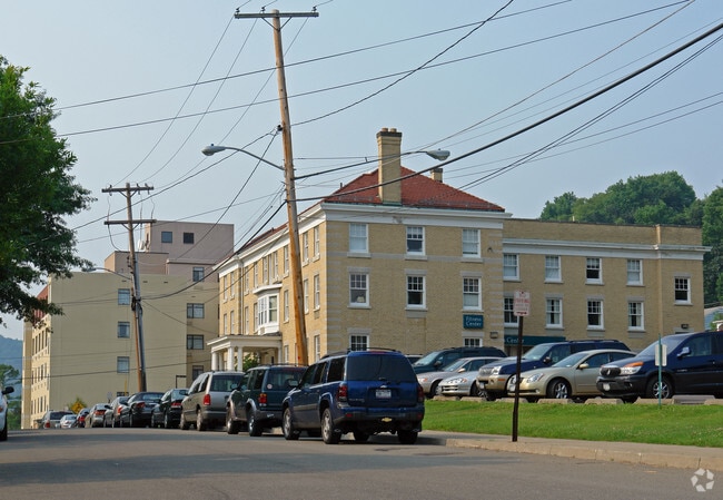
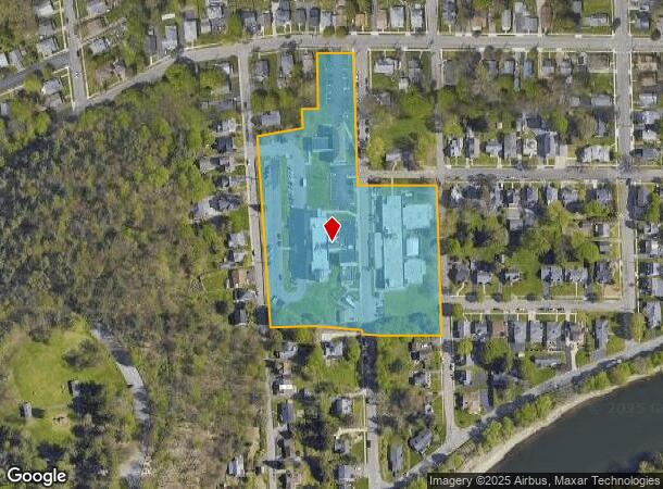
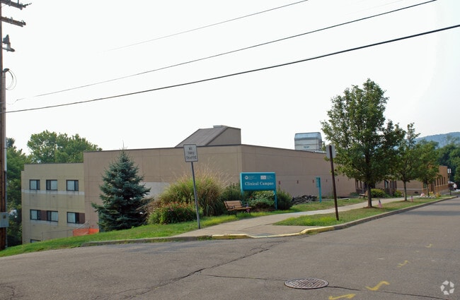
600 High Ave
Binghamton, NY
NURSING FAC 0020L4019700X0000000
034601-157-013-0007-038-000-0000
Broome
Retirementnursinghomecombined
New York
2024
38.000
2024
5.60 AC
013700
Broome County
79,800 SF
Syracuse
DEMOGRAPHICS near 600 High Ave
1 Mile
3 Mile
5 Mile
2024 Total Population
9,498
37,876
64,363
2029 Population
9,221
36,877
62,945
Pop Growth 2024-2029
(2.92%)
(2.64%)
(2.20%)
Average Age
43
43
43
2024 Total Households
4,345
16,932
26,786
HH Growth 2024-2029
(3.06%)
(2.78%)
(2.40%)
Median Household Inc
$55,635
$60,412
$68,423
Avg Household Size
2.10
2.10
2.20
2024 Avg HH Vehicles
1.00
2.00
2.00
Median Home Value
$112,594
$136,591
$154,547
Median Year Built
1948
1954
1960
Nearby Places
- Restaurants
- Banks
- Shops
- Fitness
- Groceries
PUBLIC TRANSPORTATION
AIRPORT
Ithaca Tompkins International
DRIVE
WALK
Distance
Ithaca Tompkins International
75 min
44.8 mi
Nearby Properties
Address
Land Use
TOTAL SIZE
Lot Size
Zoning
Address
Land Use
TOTAL SIZE
Lot Size
Zoning
Address
Land Use
TOTAL SIZE
Lot Size
Zoning
198,892 SF
40.31 AC
RR
Address
Land Use
TOTAL SIZE
Lot Size
Zoning
206,537 SF
15.02 AC
C-2
Address
Land Use
TOTAL SIZE
Lot Size
Zoning
93,010 SF
12.32 AC
Address
Land Use
TOTAL SIZE
Lot Size
Zoning
68,546 SF
28.40 AC
Address
Land Use
TOTAL SIZE
Lot Size
Zoning
71,076 SF
12.22 AC
RR
Address
Land Use
TOTAL SIZE
Lot Size
Zoning
Address
Land Use
TOTAL SIZE
Lot Size
Zoning
122,980 SF
5.85 AC
RC
Address
Land Use
TOTAL SIZE
Lot Size
Zoning
29,750 SF
14.38 AC
RA-2
Address
Land Use
TOTAL SIZE
Lot Size
Zoning
69,590 SF
8.51 AC
C-1
Address
Land Use
TOTAL SIZE
Lot Size
Zoning
51,861 SF
13.44 AC
RA-2
Address
Land Use
TOTAL SIZE
Lot Size
Zoning
16,658 SF
1.97 AC
C-1
Address
Land Use
TOTAL SIZE
Lot Size
Zoning
15,840 SF
8.06 AC
RA-2
Address
Land Use
TOTAL SIZE
Lot Size
Zoning
31,846 SF
5.41 AC
RA-2
Address
Land Use
TOTAL SIZE
Lot Size
Zoning
31,063 SF
5.88 AC
CD
Address
Land Use
TOTAL SIZE
Lot Size
Zoning
55,540 SF
4.02 AC
CD
Address
Land Use
TOTAL SIZE
Lot Size
Zoning
17,356 SF
2.25 AC
RA-2
Address
Land Use
TOTAL SIZE
Lot Size
Zoning
53,280 SF
5.26 AC
Address
Land Use
TOTAL SIZE
Lot Size
Zoning
15,440 SF
14.53 AC
RR
Address
Land Use
TOTAL SIZE
Lot Size
Zoning
11,750 SF
1.05 AC
RA-2
Address
Land Use
TOTAL SIZE
Lot Size
Zoning
26,704 SF
2.40 AC
CD
Address
Land Use
TOTAL SIZE
Lot Size
Zoning
21,050 SF
4.54 AC
C-1
Address
Land Use
TOTAL SIZE
Lot Size
Zoning
4,924 SF
2.05 AC
RA-2
Address
Land Use
TOTAL SIZE
Lot Size
Zoning
25,500 SF
2.85 AC
CD
Address
Land Use
TOTAL SIZE
Lot Size
Zoning
1,536 SF
97.49 AC
RR
Address
Land Use
TOTAL SIZE
Lot Size
Zoning
12,984 SF
3.20 AC
C2
Address
Land Use
TOTAL SIZE
Lot Size
Zoning
58,561 SF
7.09 AC
C-2
Address
Land Use
TOTAL SIZE
Lot Size
Zoning
9,100 SF
1.78 AC
C-1
Address
Land Use
TOTAL SIZE
Lot Size
Zoning
7,632 SF
4.85 AC
C-1
Address
Land Use
TOTAL SIZE
Lot Size
Zoning
0.77 AC
RA-2
The World's #1 Commercial Real Estate Marketplace
Connect with us
© 2025 CoStar Group
The information above has been obtained from sources believed reliable. While we do not doubt its accuracy we have not verified it and make no guarantee, warranty or representation about it. It is your responsibility to independently confirm its accuracy and completeness. Any projections, opinions, assumptions, or estimates used are for example only and do not represent the current or future performance of the property. The value of this transaction to you depends on tax and other factors which should be evaluated by your tax, financial, and legal advisors. You and your advisors should conduct a careful, independent investigation of the property to determine to your satisfaction the suitability of the property for your needs.