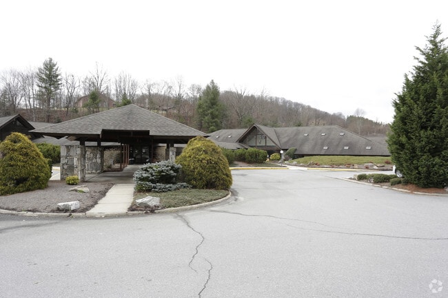
Property Record
600 Hospital Dr, Clyde, NC 28721

Property Detail
600 Hospital Dr
8626-59-7806
600 HOSPITAL DR
Medicalbuilding
Haywood
B and X Area of moderate flood hazard, usually the area between the limits of the 100-year and 500-year floods.
North Carolina
2025
2.92 AC
2026
Haywood County
921000
Asheville
4,006 SF
Waynesville, NC
NEARBY LISTINGS FOR SALE OR LEASE
DEMOGRAPHICS near 600 Hospital Dr
1 mile
3 mile
5 mile
2025 Total Population
1,932
11,896
27,448
2030 Population
1,917
11,798
27,436
Pop Growth 2025-2030
(0.78%)
(0.82%)
(0.04%)
Average Age
45
45
46
2025 Total Households
832
5,153
12,068
HH Growth 2025-2030
(0.84%)
(0.87%)
(0.07%)
Median Household Inc
$63,421
$68,855
$59,881
Avg Household Size
2.20
2.20
2.20
2025 Avg HH Vehicles
2.00
2.00
2.00
Median Home Value
$284,119
$294,873
$292,453
Median Year Built
1982
1980
1979
Nearby Places
Map Layers
Map Styles
 Street
 Aerial
Layers
 Traffic
 Biking
Places
Listings with unknown addresses are not visible on the map
- Restaurants
- Banks
- Shops
- Fitness
- Groceries
PUBLIC TRANSPORTATION
AIRPORT
Asheville Regional
Drive
Walk
Distance
Asheville Regional
40 min
30.6 mi
Freight Ports
North Charleston Terminal
Drive
Walk
Distance
North Charleston Terminal
312 min
274.4 mi
SALE & LEASE HISTORY
LISTING DATE
SALE/LEASE

Sep 25, 2016
For Lease
Jun 19, 2023
For Lease
Jan 10, 2018
For Lease
Dec 07, 2021
For Lease
Nearby Properties
Address
Land Use
TOTAL SIZE
Lot Size
Zoning
Address
Land Use
TOTAL SIZE
Lot Size
Zoning
52,051 SF
55.78 AC
Address
Land Use
TOTAL SIZE
Lot Size
Zoning
1,500 SF
294.65 AC
Address
Land Use
TOTAL SIZE
Lot Size
Zoning
23,615 SF
7.17 AC
Address
Land Use
TOTAL SIZE
Lot Size
Zoning
5,800 SF
54.05 AC
COI
Address
Land Use
TOTAL SIZE
Lot Size
Zoning
2,685 SF
10.41 AC
HTD
Address
Land Use
TOTAL SIZE
Lot Size
Zoning
17,244 SF
40.20 AC
Address
Land Use
TOTAL SIZE
Lot Size
Zoning
37,508 SF
3.44 AC
DJAC
Address
Land Use
TOTAL SIZE
Lot Size
Zoning
87,969 SF
19.78 AC
RATC
Address
Land Use
TOTAL SIZE
Lot Size
Zoning
12,520 SF
3.26 AC
COI
Address
Land Use
TOTAL SIZE
Lot Size
Zoning
19,943 SF
13.52 AC
Address
Land Use
TOTAL SIZE
Lot Size
Zoning
94,031 SF
16.74 AC
RATC
Address
Land Use
TOTAL SIZE
Lot Size
Zoning
35,901 SF
12.80 AC
Address
Land Use
TOTAL SIZE
Lot Size
Zoning
16,836 SF
0.57 AC
Address
Land Use
TOTAL SIZE
Lot Size
Zoning
115,911 SF
16.92 AC
Address
Land Use
TOTAL SIZE
Lot Size
Zoning
13,608 SF
22.01 AC
RCND
Address
Land Use
TOTAL SIZE
Lot Size
Zoning
52,904 SF
23.08 AC
HMND
Address
Land Use
TOTAL SIZE
Lot Size
Zoning
14,806 SF
9.76 AC
Address
Land Use
TOTAL SIZE
Lot Size
Zoning
277,784 SF
35.12 AC
HTD
Address
Land Use
TOTAL SIZE
Lot Size
Zoning
30,460 SF
13.04 AC
Address
Land Use
TOTAL SIZE
Lot Size
Zoning
124,013 SF
11.81 AC
RATC
Address
Land Use
TOTAL SIZE
Lot Size
Zoning
5,152 SF
2.01 AC
Address
Land Use
TOTAL SIZE
Lot Size
Zoning
28,922 SF
28.92 AC
Address
Land Use
TOTAL SIZE
Lot Size
Zoning
4,031 SF
96.51 AC
Address
Land Use
TOTAL SIZE
Lot Size
Zoning
119,364 SF
8.05 AC
RATC
Address
Land Use
TOTAL SIZE
Lot Size
Zoning
25,536 SF
7.91 AC
RCNC
Address
Land Use
TOTAL SIZE
Lot Size
Zoning
48,438 SF
5.25 AC
Address
Land Use
TOTAL SIZE
Lot Size
Zoning
1,800 SF
4.21 AC
Address
Land Use
TOTAL SIZE
Lot Size
Zoning
7,592 SF
3.66 AC
CC2
Address
Land Use
TOTAL SIZE
Lot Size
Zoning
7,014 SF
6.23 AC
The World's #1 Commercial Real Estate Marketplace
Connect with us
© 2026 CoStar Group
The information above has been obtained from sources believed reliable. While we do not doubt its accuracy we have not verified it and make no guarantee, warranty or representation about it. It is your responsibility to independently confirm its accuracy and completeness. Any projections, opinions, assumptions, or estimates used are for example only and do not represent the current or future performance of the property. The value of this transaction to you depends on tax and other factors which should be evaluated by your tax, financial, and legal advisors. You and your advisors should conduct a careful, independent investigation of the property to determine to your satisfaction the suitability of the property for your needs.