Property Record
598 Main Ave, Passaic, NJ 07055
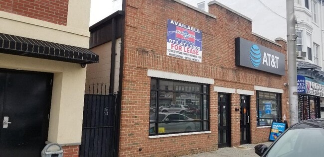

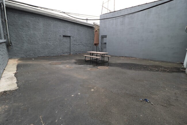
Property Detail
598 Main Ave
New York-Jersey City-White Plains, NY-NJ
ADDITIONAL LOTS: 9,PT.L-8
07-01134-0000-00010
Passaic
Apartment
New Jersey
C-R
10
B and X Area of moderate flood hazard, usually the area between the limits of the 100-year and 500-year floods.
0.13 AC
2024
Route 3/GSP
2025
Northern New Jersey
175402
NEARBY LISTINGS FOR SALE OR LEASE
DEMOGRAPHICS near 598 Main Ave
1 mile
3 mile
5 mile
2025 Total Population
67,325
292,420
648,769
2030 Population
68,282
295,793
660,322
Pop Growth 2025-2030
+ 1.42%
+ 1.15%
+ 1.78%
Average Age
36
39
40
2025 Total Households
20,362
102,247
231,252
HH Growth 2025-2030
+ 1.30%
+ 1.16%
+ 1.89%
Median Household Inc
$53,352
$86,476
$89,320
Avg Household Size
3.20
2.80
2.70
2025 Avg HH Vehicles
1.00
2.00
2.00
Median Home Value
$433,566
$484,136
$479,654
Median Year Built
1948
1952
1954
Nearby Places
Map Layers
Map Styles
 Street
 Aerial
Transit
 Traffic
 Biking
Places
Listings with unknown addresses are not visible on the map
- Restaurants
- Banks
- Shops
- Fitness
- Groceries
SALE & LEASE HISTORY
LISTING DATE
SALE/LEASE

Jan 04, 2020
For Lease
Apr 10, 2018
For Lease
Apr 02, 2019
For Lease
Nearby Properties
Address
Land Use
TOTAL SIZE
Lot Size
Zoning
Address
Land Use
TOTAL SIZE
Lot Size
Zoning
Address
Land Use
TOTAL SIZE
Lot Size
Zoning
4,014 SF
21 AC
Address
Land Use
TOTAL SIZE
Lot Size
Zoning
612 AC
SEA
Address
Land Use
TOTAL SIZE
Lot Size
Zoning
9.57 AC
I2
Address
Land Use
TOTAL SIZE
Lot Size
Zoning
7.10 AC
R-3
Address
Land Use
TOTAL SIZE
Lot Size
Zoning
Address
Land Use
TOTAL SIZE
Lot Size
Zoning
1.12 AC
M-O
Address
Land Use
TOTAL SIZE
Lot Size
Zoning
7.29 AC
Address
Land Use
TOTAL SIZE
Lot Size
Zoning
Address
Land Use
TOTAL SIZE
Lot Size
Zoning
138,764 SF
1.47 AC
LM
Address
Land Use
TOTAL SIZE
Lot Size
Zoning
25.50 AC
B2
Address
Land Use
TOTAL SIZE
Lot Size
Zoning
26,816 SF
25.50 AC
POP
Address
Land Use
TOTAL SIZE
Lot Size
Zoning
24.29 AC
Address
Land Use
TOTAL SIZE
Lot Size
Zoning
82.74 AC
Address
Land Use
TOTAL SIZE
Lot Size
Zoning
16.94 AC
R2
Address
Land Use
TOTAL SIZE
Lot Size
Zoning
24.35 AC
Address
Land Use
TOTAL SIZE
Lot Size
Zoning
13.80 AC
Address
Land Use
TOTAL SIZE
Lot Size
Zoning
11.30 AC
Address
Land Use
TOTAL SIZE
Lot Size
Zoning
148,918 SF
4.17 AC
B
Address
Land Use
TOTAL SIZE
Lot Size
Zoning
13.36 AC
Address
Land Use
TOTAL SIZE
Lot Size
Zoning
136,148 SF
12.81 AC
Address
Land Use
TOTAL SIZE
Lot Size
Zoning
177,672 SF
7.51 AC
IA
Address
Land Use
TOTAL SIZE
Lot Size
Zoning
7.22 AC
M-3
Address
Land Use
TOTAL SIZE
Lot Size
Zoning
31.63 AC
I
Address
Land Use
TOTAL SIZE
Lot Size
Zoning
9.38 AC
B-A
Address
Land Use
TOTAL SIZE
Lot Size
Zoning
18.14 AC
R3
Address
Land Use
TOTAL SIZE
Lot Size
Zoning
20,866 SF
Address
Land Use
TOTAL SIZE
Lot Size
Zoning
4.09 AC
M-O
Address
Land Use
TOTAL SIZE
Lot Size
Zoning
11.40 AC
Address
Land Use
TOTAL SIZE
Lot Size
Zoning
21.80 AC
R-A3
The World's #1 Commercial Real Estate Marketplace
Connect with us
© 2026 CoStar Group
The information above has been obtained from sources believed reliable. While we do not doubt its accuracy we have not verified it and make no guarantee, warranty or representation about it. It is your responsibility to independently confirm its accuracy and completeness. Any projections, opinions, assumptions, or estimates used are for example only and do not represent the current or future performance of the property. The value of this transaction to you depends on tax and other factors which should be evaluated by your tax, financial, and legal advisors. You and your advisors should conduct a careful, independent investigation of the property to determine to your satisfaction the suitability of the property for your needs.