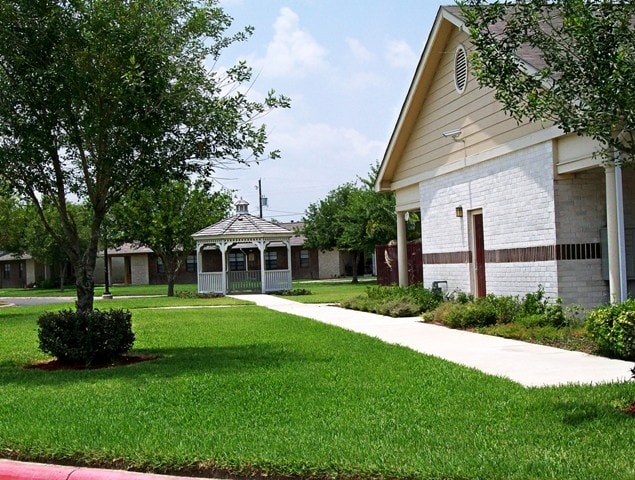
Property Record
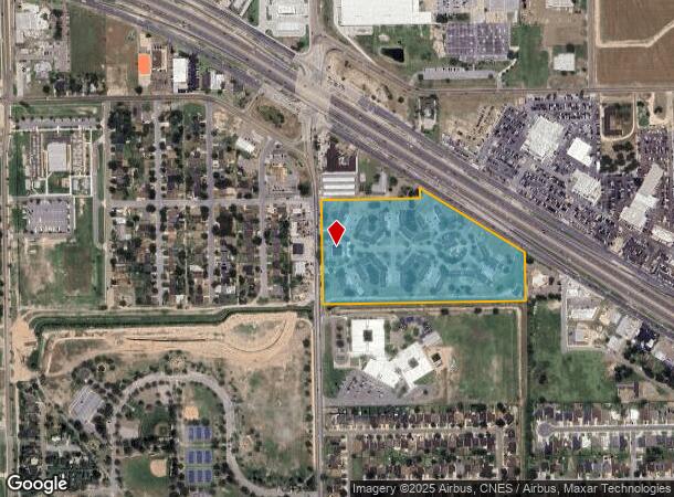
600 N Airport Dr, Weslaco, TX 78596

NEARBY LISTINGS FOR SALE OR LEASE
Property Detail
600 N Airport Dr
McAllen-Edinburg-Mission, TX
West Tract - Swl
W3800-00-015-0000-02
WEST TRACT FT 15 S10AC-W20 & S6.26AC-E10 16.26AC NET
Apartment
Hidalgo
0
Texas
2025
16.26 AC
022502
Donna/Weslaco/Mercedes
79,517 SF
McAllen/Edinburg/Pharr
DEMOGRAPHICS near 600 N Airport Dr
1 Mile
3 Mile
5 Mile
2024 Total Population
7,419
56,273
112,515
2029 Population
8,022
60,245
119,466
Pop Growth 2024-2029
+ 8.13%
+ 7.06%
+ 6.18%
Average Age
37
36
36
2024 Total Households
2,423
18,183
34,185
HH Growth 2024-2029
+ 8.25%
+ 7.33%
+ 6.56%
Median Household Inc
$40,495
$46,033
$43,218
Avg Household Size
3.00
3.00
3.20
2024 Avg HH Vehicles
2.00
2.00
2.00
Median Home Value
$68,921
$91,136
$85,006
Median Year Built
1989
1995
1994
Nearby Places
Map Layers
Map Styles
 Street
 Aerial
- Restaurants
- Banks
- Shops
- Fitness
- Groceries
PUBLIC TRANSPORTATION
AIRPORT
McAllen International
DRIVE
WALK
Distance
McAllen International
24 min
18.3 mi
Valley International
DRIVE
WALK
Distance
Valley International
31 min
23.5 mi
Freight Ports
Port of Brownsville
DRIVE
WALK
Distance
Port of Brownsville
48 min
42.8 mi
Nearby Properties
Address
Land Use
TOTAL SIZE
Lot Size
Zoning
Address
Land Use
TOTAL SIZE
Lot Size
Zoning
401,046 SF
13.97 AC
Address
Land Use
TOTAL SIZE
Lot Size
Zoning
307,987 SF
39.11 AC
Address
Land Use
TOTAL SIZE
Lot Size
Zoning
552,365 SF
72.02 AC
GT
Address
Land Use
TOTAL SIZE
Lot Size
Zoning
255,276 SF
25 AC
Address
Land Use
TOTAL SIZE
Lot Size
Zoning
415,762 SF
56.31 AC
CO
Address
Land Use
TOTAL SIZE
Lot Size
Zoning
258,111 SF
51.09 AC
Address
Land Use
TOTAL SIZE
Lot Size
Zoning
205,544 SF
20.48 AC
C
Address
Land Use
TOTAL SIZE
Lot Size
Zoning
113,449 SF
19.01 AC
Address
Land Use
TOTAL SIZE
Lot Size
Zoning
197,394 SF
14.28 AC
CO
Address
Land Use
TOTAL SIZE
Lot Size
Zoning
2 SF
48.88 AC
GT
Address
Land Use
TOTAL SIZE
Lot Size
Zoning
342,760 SF
42.33 AC
Address
Land Use
TOTAL SIZE
Lot Size
Zoning
108,541 SF
16.50 AC
Address
Land Use
TOTAL SIZE
Lot Size
Zoning
5 SF
46.56 AC
GT
Address
Land Use
TOTAL SIZE
Lot Size
Zoning
108.55 AC
MP
Address
Land Use
TOTAL SIZE
Lot Size
Zoning
76,552 SF
19.48 AC
CO
Address
Land Use
TOTAL SIZE
Lot Size
Zoning
28,768 SF
3.20 AC
Address
Land Use
TOTAL SIZE
Lot Size
Zoning
4,174 SF
19.70 AC
Address
Land Use
TOTAL SIZE
Lot Size
Zoning
57,032 SF
1.82 AC
CO
Address
Land Use
TOTAL SIZE
Lot Size
Zoning
112,706 SF
10.13 AC
Address
Land Use
TOTAL SIZE
Lot Size
Zoning
135,639 SF
40 AC
Address
Land Use
TOTAL SIZE
Lot Size
Zoning
97,698 SF
10.73 AC
CO
Address
Land Use
TOTAL SIZE
Lot Size
Zoning
61,420 SF
5.01 AC
CO
Address
Land Use
TOTAL SIZE
Lot Size
Zoning
13 SF
29 AC
Address
Land Use
TOTAL SIZE
Lot Size
Zoning
49,538 SF
8 AC
Address
Land Use
TOTAL SIZE
Lot Size
Zoning
9 SF
15.24 AC
Address
Land Use
TOTAL SIZE
Lot Size
Zoning
63,469 SF
37.86 AC
CO
Address
Land Use
TOTAL SIZE
Lot Size
Zoning
70,035 SF
16.46 AC
Address
Land Use
TOTAL SIZE
Lot Size
Zoning
94,901 SF
8.80 AC
CO
Address
Land Use
TOTAL SIZE
Lot Size
Zoning
42,589 SF
4.46 AC
The World's #1 Commercial Real Estate Marketplace
Connect with us
© 2025 CoStar Group
The information above has been obtained from sources believed reliable. While we do not doubt its accuracy we have not verified it and make no guarantee, warranty or representation about it. It is your responsibility to independently confirm its accuracy and completeness. Any projections, opinions, assumptions, or estimates used are for example only and do not represent the current or future performance of the property. The value of this transaction to you depends on tax and other factors which should be evaluated by your tax, financial, and legal advisors. You and your advisors should conduct a careful, independent investigation of the property to determine to your satisfaction the suitability of the property for your needs.