Property Record
600 N Harding Ave, Sedalia, MO 65301
NEARBY LISTINGS FOR SALE OR LEASE
-
-
View all Sedalia listings for sale on LoopNet.com
Property Detail
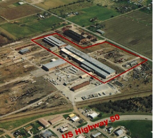
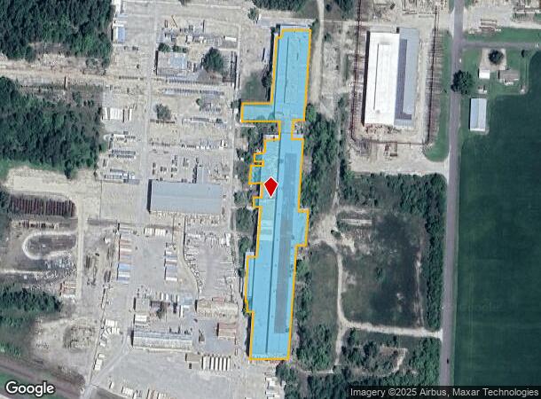
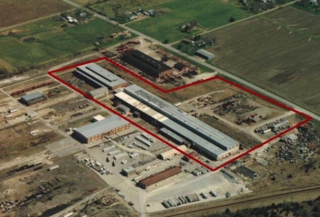
600 N Harding Ave
Sedalia, MO
PART SENE ACRE 2 45 21
151002103004001
Pettis
Warehouse
Missouri
2025
3.76 AC
2024
Missouri North Area
481100
Other Market Areas
115,156 SF
DEMOGRAPHICS near 600 N Harding Ave
1 Mile
3 Mile
5 Mile
2024 Total Population
2,585
21,193
30,454
2029 Population
2,663
21,766
31,181
Pop Growth 2024-2029
+ 3.02%
+ 2.70%
+ 2.39%
Average Age
39
38
39
2024 Total Households
1,042
8,200
12,066
HH Growth 2024-2029
+ 2.88%
+ 2.70%
+ 2.44%
Median Household Inc
$42,469
$48,628
$50,293
Avg Household Size
2.40
2.40
2.40
2024 Avg HH Vehicles
2.00
2.00
2.00
Median Home Value
$121,918
$110,623
$135,267
Median Year Built
1967
1961
1968
Nearby Places
Map Layers
Map Styles
 Street
 Aerial
- Restaurants
- Banks
- Shops
- Fitness
- Groceries
PUBLIC TRANSPORTATION
COMMUTER RAIL
Sedalia Amtrak Station (Lincoln Service Missouri River Runner - Amtrak, Missouri River Runner - Amtrak)
DRIVE
WALK
Distance
Sedalia Amtrak Station (Lincoln Service Missouri River Runner - Amtrak, Missouri River Runner - Amtrak)
9 min
3.2 mi
Freight Ports
Tulsa Port Of Catoosa
DRIVE
WALK
Distance
Tulsa Port Of Catoosa
321 min
275.1 mi
SALE & LEASE HISTORY
LISTING DATE
SALE/LEASE

Sep 25, 2016
For Lease
Sep 24, 2016
For Sale
May 11, 2018
For Sale
Nearby Properties
Address
Land Use
TOTAL SIZE
Lot Size
Zoning
Address
Land Use
TOTAL SIZE
Lot Size
Zoning
Address
Land Use
TOTAL SIZE
Lot Size
Zoning
66,910 SF
44.75 AC
Address
Land Use
TOTAL SIZE
Lot Size
Zoning
8,699 SF
0.70 AC
Address
Land Use
TOTAL SIZE
Lot Size
Zoning
18,000 SF
342.42 AC
Address
Land Use
TOTAL SIZE
Lot Size
Zoning
14,190 SF
1.58 AC
Address
Land Use
TOTAL SIZE
Lot Size
Zoning
63,240 SF
6.12 AC
Address
Land Use
TOTAL SIZE
Lot Size
Zoning
6,088 SF
7.02 AC
Address
Land Use
TOTAL SIZE
Lot Size
Zoning
75,245 SF
1.04 AC
Address
Land Use
TOTAL SIZE
Lot Size
Zoning
23,188 SF
0.74 AC
Address
Land Use
TOTAL SIZE
Lot Size
Zoning
2,016 SF
10 AC
Address
Land Use
TOTAL SIZE
Lot Size
Zoning
18,272 SF
7.20 AC
Address
Land Use
TOTAL SIZE
Lot Size
Zoning
13,137 SF
1.63 AC
Address
Land Use
TOTAL SIZE
Lot Size
Zoning
116,144 SF
5.49 AC
Address
Land Use
TOTAL SIZE
Lot Size
Zoning
58,721 SF
11.95 AC
Address
Land Use
TOTAL SIZE
Lot Size
Zoning
13,122 SF
1.52 AC
Address
Land Use
TOTAL SIZE
Lot Size
Zoning
50,960 SF
2.64 AC
Address
Land Use
TOTAL SIZE
Lot Size
Zoning
18,000 SF
4.86 AC
Address
Land Use
TOTAL SIZE
Lot Size
Zoning
54,914 SF
4.70 AC
Address
Land Use
TOTAL SIZE
Lot Size
Zoning
7,959 SF
0.77 AC
Address
Land Use
TOTAL SIZE
Lot Size
Zoning
12,225 SF
7 AC
Address
Land Use
TOTAL SIZE
Lot Size
Zoning
8,452 SF
3.80 AC
Address
Land Use
TOTAL SIZE
Lot Size
Zoning
10,424 SF
0.05 AC
Address
Land Use
TOTAL SIZE
Lot Size
Zoning
68,955 SF
4.71 AC
Address
Land Use
TOTAL SIZE
Lot Size
Zoning
4,986 SF
Address
Land Use
TOTAL SIZE
Lot Size
Zoning
3,120 SF
2.32 AC
Address
Land Use
TOTAL SIZE
Lot Size
Zoning
41,500 SF
1.87 AC
Address
Land Use
TOTAL SIZE
Lot Size
Zoning
2,000 SF
22.75 AC
Address
Land Use
TOTAL SIZE
Lot Size
Zoning
2,520 SF
11.04 AC
Address
Land Use
TOTAL SIZE
Lot Size
Zoning
7,700 SF
2.77 AC
Address
Land Use
TOTAL SIZE
Lot Size
Zoning
39,868 SF
0.34 AC
The World's #1 Commercial Real Estate Marketplace
Connect with us
© 2025 CoStar Group
The information above has been obtained from sources believed reliable. While we do not doubt its accuracy we have not verified it and make no guarantee, warranty or representation about it. It is your responsibility to independently confirm its accuracy and completeness. Any projections, opinions, assumptions, or estimates used are for example only and do not represent the current or future performance of the property. The value of this transaction to you depends on tax and other factors which should be evaluated by your tax, financial, and legal advisors. You and your advisors should conduct a careful, independent investigation of the property to determine to your satisfaction the suitability of the property for your needs.