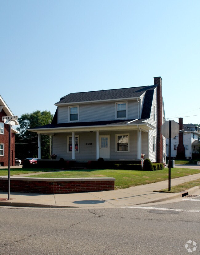
Property Record
600 N Main St, North Canton, OH 44720


Property Detail
600 N Main St
09200046
689 WH EX 5NS
Storebuilding
Stark
B and X Area of moderate flood hazard, usually the area between the limits of the 100-year and 500-year floods.
Ohio
0
0.13 AC
2025
Stark County
712000
Cleveland
1,344 SF
Canton-Massillon, OH
NEARBY LISTINGS FOR SALE OR LEASE
DEMOGRAPHICS near 600 N Main St
1 mile
3 mile
5 mile
2025 Total Population
9,985
49,564
118,600
2030 Population
9,912
50,234
119,284
Pop Growth 2025-2030
(0.73%)
+ 1.35%
+ 0.58%
Average Age
42
43
43
2025 Total Households
4,646
21,449
50,994
HH Growth 2025-2030
(0.77%)
+ 1.37%
+ 0.59%
Median Household Inc
$66,824
$73,667
$72,028
Avg Household Size
2.10
2.20
2.20
2025 Avg HH Vehicles
2.00
2.00
2.00
Median Home Value
$188,180
$249,409
$233,912
Median Year Built
1970
1978
1973
Nearby Places
Map Layers
Map Styles
 Street
 Aerial
Transit
 Traffic
 Biking
Places
Listings with unknown addresses are not visible on the map
- Restaurants
- Banks
- Shops
- Fitness
- Groceries
PUBLIC TRANSPORTATION
AIRPORT
Akron-Canton Regional
Drive
Walk
Distance
Akron-Canton Regional
8 min
3.7 mi
Freight Ports
Port of Toledo
Drive
Walk
Distance
Port of Toledo
180 min
151.5 mi
SALE & LEASE HISTORY
LISTING DATE
SALE/LEASE

Jun 06, 2019
For Sale
Jan 21, 2019
For Sale
Apr 24, 2019
For Sale
Nearby Properties
Address
Land Use
TOTAL SIZE
Lot Size
Zoning
Address
Land Use
TOTAL SIZE
Lot Size
Zoning
730,347 SF
55.42 AC
Address
Land Use
TOTAL SIZE
Lot Size
Zoning
223,734 SF
1,140.33 AC
Address
Land Use
TOTAL SIZE
Lot Size
Zoning
234,168 SF
22.77 AC
Address
Land Use
TOTAL SIZE
Lot Size
Zoning
475,122 SF
81.74 AC
Address
Land Use
TOTAL SIZE
Lot Size
Zoning
494,965 SF
15.48 AC
Address
Land Use
TOTAL SIZE
Lot Size
Zoning
390,841 SF
19 AC
Address
Land Use
TOTAL SIZE
Lot Size
Zoning
103,786 SF
8.77 AC
Address
Land Use
TOTAL SIZE
Lot Size
Zoning
367,640 SF
35.46 AC
Address
Land Use
TOTAL SIZE
Lot Size
Zoning
296,562 SF
36.07 AC
Address
Land Use
TOTAL SIZE
Lot Size
Zoning
147,708 SF
4.76 AC
Address
Land Use
TOTAL SIZE
Lot Size
Zoning
356,083 SF
32.10 AC
Address
Land Use
TOTAL SIZE
Lot Size
Zoning
234,168 SF
22.17 AC
Address
Land Use
TOTAL SIZE
Lot Size
Zoning
415,636 SF
91.33 AC
Address
Land Use
TOTAL SIZE
Lot Size
Zoning
1,247.97 AC
Address
Land Use
TOTAL SIZE
Lot Size
Zoning
150,620 SF
18.25 AC
Address
Land Use
TOTAL SIZE
Lot Size
Zoning
140,060 SF
27.57 AC
Address
Land Use
TOTAL SIZE
Lot Size
Zoning
106,867 SF
13.43 AC
Address
Land Use
TOTAL SIZE
Lot Size
Zoning
294,409 SF
18.85 AC
Address
Land Use
TOTAL SIZE
Lot Size
Zoning
103,786 SF
8.51 AC
Address
Land Use
TOTAL SIZE
Lot Size
Zoning
171,663 SF
16.77 AC
Address
Land Use
TOTAL SIZE
Lot Size
Zoning
118,889 SF
19.77 AC
Address
Land Use
TOTAL SIZE
Lot Size
Zoning
Address
Land Use
TOTAL SIZE
Lot Size
Zoning
218,864 SF
11.84 AC
Address
Land Use
TOTAL SIZE
Lot Size
Zoning
151,342 SF
14.49 AC
Address
Land Use
TOTAL SIZE
Lot Size
Zoning
160,650 SF
17.26 AC
Address
Land Use
TOTAL SIZE
Lot Size
Zoning
155,328 SF
22.08 AC
Address
Land Use
TOTAL SIZE
Lot Size
Zoning
255,406 SF
25.19 AC
Address
Land Use
TOTAL SIZE
Lot Size
Zoning
80,416 SF
81.53 AC
Address
Land Use
TOTAL SIZE
Lot Size
Zoning
195,551 SF
37.77 AC
Address
Land Use
TOTAL SIZE
Lot Size
Zoning
50,062 SF
8.51 AC
The World's #1 Commercial Real Estate Marketplace
Connect with us
© 2026 CoStar Group
The information above has been obtained from sources believed reliable. While we do not doubt its accuracy we have not verified it and make no guarantee, warranty or representation about it. It is your responsibility to independently confirm its accuracy and completeness. Any projections, opinions, assumptions, or estimates used are for example only and do not represent the current or future performance of the property. The value of this transaction to you depends on tax and other factors which should be evaluated by your tax, financial, and legal advisors. You and your advisors should conduct a careful, independent investigation of the property to determine to your satisfaction the suitability of the property for your needs.