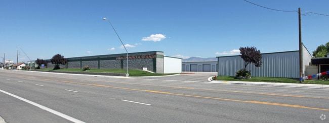
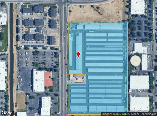
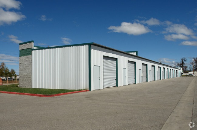
Property Record
600 N Maple Grove Rd, Boise, ID 83704
NEARBY LISTINGS FOR SALE OR LEASE
Property Detail
600 N Maple Grove Rd
S1112325855
PAR #5855 @ W SIDE SW4 SEC 12 3N 1E #325850-B
Commercialbuilding
Ada
X
Idaho
16001C0260G
14.77 AC
2024
West Boise
2025
Boise City/Nampa
002319
Boise City, ID
323,236 SF
DEMOGRAPHICS near 600 N Maple Grove Rd
1 Mile
3 Mile
5 Mile
2024 Total Population
10,244
103,187
273,755
2029 Population
11,549
116,331
310,106
Pop Growth 2024-2029
+ 12.74%
+ 12.74%
+ 13.28%
Average Age
38
40
40
2024 Total Households
4,008
40,802
109,742
HH Growth 2024-2029
+ 12.90%
+ 13.05%
+ 13.65%
Median Household Inc
$65,856
$65,515
$69,277
Avg Household Size
2.40
2.40
2.40
2024 Avg HH Vehicles
2.00
2.00
2.00
Median Home Value
$390,290
$382,931
$437,547
Median Year Built
1991
1986
1992
Nearby Places
Map Layers
Map Styles
 Street
 Aerial
- Restaurants
- Banks
- Shops
- Fitness
- Groceries
PUBLIC TRANSPORTATION
AIRPORT
Boise Air Trml/Gowen Field
DRIVE
WALK
Distance
Boise Air Trml/Gowen Field
26 min
10.1 mi
Freight Ports
Port of Portland
DRIVE
WALK
Distance
Port of Portland
474 min
429.5 mi
Nearby Properties
Address
Land Use
TOTAL SIZE
Lot Size
Zoning
Address
Land Use
TOTAL SIZE
Lot Size
Zoning
533,727 SF
22.89 AC
C-G
Address
Land Use
TOTAL SIZE
Lot Size
Zoning
646,787 SF
27.37 AC
ZC-243
Address
Land Use
TOTAL SIZE
Lot Size
Zoning
505,966 SF
51.08 AC
L-O
Address
Land Use
TOTAL SIZE
Lot Size
Zoning
334,124 SF
11.21 AC
R-3
Address
Land Use
TOTAL SIZE
Lot Size
Zoning
269,509 SF
12 AC
R-40
Address
Land Use
TOTAL SIZE
Lot Size
Zoning
207,033 SF
10.67 AC
ZC-243
Address
Land Use
TOTAL SIZE
Lot Size
Zoning
225,032 SF
12.75 AC
R-3
Address
Land Use
TOTAL SIZE
Lot Size
Zoning
230,810 SF
20.09 AC
C-G
Address
Land Use
TOTAL SIZE
Lot Size
Zoning
150,000 SF
5.44 AC
C-G
Address
Land Use
TOTAL SIZE
Lot Size
Zoning
249,800 SF
12.99 AC
ZC-243
Address
Land Use
TOTAL SIZE
Lot Size
Zoning
147,239 SF
7.56 AC
C-G
Address
Land Use
TOTAL SIZE
Lot Size
Zoning
319,052 SF
24.33 AC
ZC-243
Address
Land Use
TOTAL SIZE
Lot Size
Zoning
222,379 SF
1.37 AC
M
Address
Land Use
TOTAL SIZE
Lot Size
Zoning
167,416 SF
18.57 AC
C-G
Address
Land Use
TOTAL SIZE
Lot Size
Zoning
125,362 SF
7.08 AC
C-G
Address
Land Use
TOTAL SIZE
Lot Size
Zoning
211,039 SF
12.21 AC
ZC-243
Address
Land Use
TOTAL SIZE
Lot Size
Zoning
162,432 SF
8.31 AC
R-3
Address
Land Use
TOTAL SIZE
Lot Size
Zoning
72,579 SF
4.48 AC
ZC-269
Address
Land Use
TOTAL SIZE
Lot Size
Zoning
176,494 SF
10.16 AC
R-1C
Address
Land Use
TOTAL SIZE
Lot Size
Zoning
290,239 SF
4.73 AC
ZC-243
Address
Land Use
TOTAL SIZE
Lot Size
Zoning
253,440 SF
15.19 AC
I-L
Address
Land Use
TOTAL SIZE
Lot Size
Zoning
166,184 SF
9.82 AC
ZC-269
Address
Land Use
TOTAL SIZE
Lot Size
Zoning
114,155 SF
5.61 AC
C-G
Address
Land Use
TOTAL SIZE
Lot Size
Zoning
116,192 SF
7.14 AC
R-40
Address
Land Use
TOTAL SIZE
Lot Size
Zoning
136,244 SF
8.56 AC
ZC-281
Address
Land Use
TOTAL SIZE
Lot Size
Zoning
106,397 SF
11.30 AC
C-G
Address
Land Use
TOTAL SIZE
Lot Size
Zoning
194,890 SF
11.13 AC
I-L
Address
Land Use
TOTAL SIZE
Lot Size
Zoning
118,345 SF
5.20 AC
R-2
Address
Land Use
TOTAL SIZE
Lot Size
Zoning
137,752 SF
5.13 AC
ZC-268
Address
Land Use
TOTAL SIZE
Lot Size
Zoning
127,136 SF
7.59 AC
R-3
The World's #1 Commercial Real Estate Marketplace
Connect with us
© 2026 CoStar Group
The information above has been obtained from sources believed reliable. While we do not doubt its accuracy we have not verified it and make no guarantee, warranty or representation about it. It is your responsibility to independently confirm its accuracy and completeness. Any projections, opinions, assumptions, or estimates used are for example only and do not represent the current or future performance of the property. The value of this transaction to you depends on tax and other factors which should be evaluated by your tax, financial, and legal advisors. You and your advisors should conduct a careful, independent investigation of the property to determine to your satisfaction the suitability of the property for your needs.