Property Record
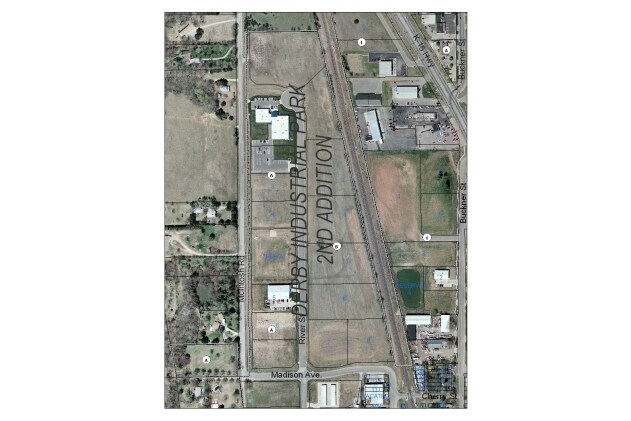
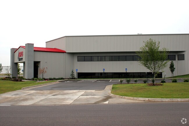
600 N River St, Derby, KS 67037


Property Detail
600 N River St
Wichita, KS
LOT 7 BLOCK B DERBY INDUSTRIAL PARK 2ND ADD.
241-01-0-34-01-008.00
Sedgwick
Warehouse
Kansas
B and X Area of moderate flood hazard, usually the area between the limits of the 100-year and 500-year floods.
7
2024
1.48 AC
2025
Derby/Haysville/Mulvane
009801
Wichita
41,134 SF
NEARBY LISTINGS FOR SALE OR LEASE
DEMOGRAPHICS near 600 N River St
1 mile
3 mile
5 mile
2025 Total Population
5,336
28,114
55,952
2030 Population
5,390
28,460
57,144
Pop Growth 2025-2030
+ 1.01%
+ 1.23%
+ 2.13%
Average Age
38
40
39
2025 Total Households
2,157
10,768
21,284
HH Growth 2025-2030
+ 1.11%
+ 1.01%
+ 2.06%
Median Household Inc
$64,106
$86,931
$74,279
Avg Household Size
2.40
2.60
2.60
2025 Avg HH Vehicles
2.00
2.00
2.00
Median Home Value
$160,671
$238,673
$197,789
Median Year Built
1961
1990
1988
Nearby Places
Map Layers
Map Styles
 Street
 Aerial
Layers
 Traffic
 Biking
Places
Listings with unknown addresses are not visible on the map
- Restaurants
- Banks
- Shops
- Fitness
- Groceries
PUBLIC TRANSPORTATION
AIRPORT
Wichita Dwight D Eisenhower Ntl
Drive
Walk
Distance
Wichita Dwight D Eisenhower Ntl
28 min
17.3 mi
Freight Ports
Tulsa Port Of Catoosa
Drive
Walk
Distance
Tulsa Port Of Catoosa
205 min
185.0 mi
Nearby Properties
Address
Land Use
TOTAL SIZE
Lot Size
Zoning
Address
Land Use
TOTAL SIZE
Lot Size
Zoning
308,541 SF
66.86 AC
R1
Address
Land Use
TOTAL SIZE
Lot Size
Zoning
172,691 SF
17.25 AC
RR
Address
Land Use
TOTAL SIZE
Lot Size
Zoning
202,301 SF
34.22 AC
R1
Address
Land Use
TOTAL SIZE
Lot Size
Zoning
81,569 SF
12.09 AC
Address
Land Use
TOTAL SIZE
Lot Size
Zoning
102,574 SF
19.96 AC
R1
Address
Land Use
TOTAL SIZE
Lot Size
Zoning
82,912 SF
23.59 AC
I1
Address
Land Use
TOTAL SIZE
Lot Size
Zoning
42,611 SF
7.01 AC
B3
Address
Land Use
TOTAL SIZE
Lot Size
Zoning
49,336 SF
19.20 AC
I1
Address
Land Use
TOTAL SIZE
Lot Size
Zoning
64,858 SF
11.39 AC
R1
Address
Land Use
TOTAL SIZE
Lot Size
Zoning
67,322 SF
9.05 AC
R1
Address
Land Use
TOTAL SIZE
Lot Size
Zoning
72,472 SF
2.73 AC
R3
Address
Land Use
TOTAL SIZE
Lot Size
Zoning
37,640 SF
9.36 AC
Address
Land Use
TOTAL SIZE
Lot Size
Zoning
62,829 SF
7.15 AC
R1
Address
Land Use
TOTAL SIZE
Lot Size
Zoning
15,596 SF
11.59 AC
Address
Land Use
TOTAL SIZE
Lot Size
Zoning
37,860 SF
4.77 AC
R1
Address
Land Use
TOTAL SIZE
Lot Size
Zoning
35,032 SF
12.62 AC
I1
Address
Land Use
TOTAL SIZE
Lot Size
Zoning
49,454 SF
23 AC
Address
Land Use
TOTAL SIZE
Lot Size
Zoning
53,691 SF
8.23 AC
R1
Address
Land Use
TOTAL SIZE
Lot Size
Zoning
21,420 SF
2.39 AC
R1
Address
Land Use
TOTAL SIZE
Lot Size
Zoning
41,961 SF
3.60 AC
B3
Address
Land Use
TOTAL SIZE
Lot Size
Zoning
88,453 SF
10.91 AC
Address
Land Use
TOTAL SIZE
Lot Size
Zoning
16,392 SF
10.14 AC
R1
Address
Land Use
TOTAL SIZE
Lot Size
Zoning
52,285 SF
21.20 AC
R3
Address
Land Use
TOTAL SIZE
Lot Size
Zoning
43,300 SF
6.10 AC
I1
Address
Land Use
TOTAL SIZE
Lot Size
Zoning
33,846 SF
3.25 AC
R3
Address
Land Use
TOTAL SIZE
Lot Size
Zoning
24,900 SF
4.30 AC
Address
Land Use
TOTAL SIZE
Lot Size
Zoning
15,464 SF
0.24 AC
B4
Address
Land Use
TOTAL SIZE
Lot Size
Zoning
60,753 SF
10.02 AC
B3
Address
Land Use
TOTAL SIZE
Lot Size
Zoning
30,808 SF
1.99 AC
B3
Address
Land Use
TOTAL SIZE
Lot Size
Zoning
30,042 SF
24.90 AC
B5
The World's #1 Commercial Real Estate Marketplace
Connect with us
© 2026 CoStar Group
The information above has been obtained from sources believed reliable. While we do not doubt its accuracy we have not verified it and make no guarantee, warranty or representation about it. It is your responsibility to independently confirm its accuracy and completeness. Any projections, opinions, assumptions, or estimates used are for example only and do not represent the current or future performance of the property. The value of this transaction to you depends on tax and other factors which should be evaluated by your tax, financial, and legal advisors. You and your advisors should conduct a careful, independent investigation of the property to determine to your satisfaction the suitability of the property for your needs.