Property Record
600 Ne 46Th St, Kansas City, MO 64116
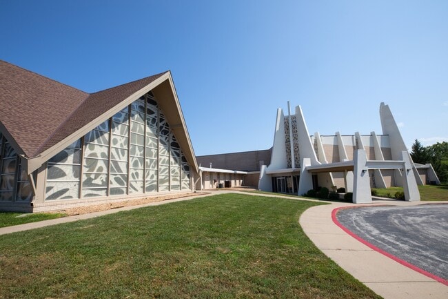


This Property Is For Sale
NEARBY LISTINGS FOR SALE OR LEASE
Property Detail
600 Ne 46Th St
Kansas City, MO-KS
Nelson Heights
17-306-00-02-001.00
F/K/A NELSON HEIGHTS (C-117) LTS 1-14 BEG SW COR LT 15 NELSON HEIGHTS, W TO EL N OAK TRFY, NLY TO SL I-29, ELY ALNG ROW TO NW COR LT 19, SE427.69, S75 TO POB
Taxexempt
Clay
X
Missouri
29095C0137G
1-14
0
5.64 AC
2025
I-35 Corridor
020201
Kansas City
DEMOGRAPHICS near 600 Ne 46Th St
1 Mile
3 Mile
5 Mile
2024 Total Population
10,449
70,286
153,657
2029 Population
10,915
73,816
161,340
Pop Growth 2024-2029
+ 4.46%
+ 5.02%
+ 5.00%
Average Age
38
40
39
2024 Total Households
4,484
30,829
65,675
HH Growth 2024-2029
+ 4.55%
+ 5.01%
+ 5.06%
Median Household Inc
$56,471
$57,584
$63,062
Avg Household Size
2.20
2.20
2.30
2024 Avg HH Vehicles
2.00
2.00
2.00
Median Home Value
$188,663
$183,408
$193,467
Median Year Built
1969
1969
1973
Nearby Places
Map Layers
Map Styles
 Street
 Aerial
- Restaurants
- Banks
- Shops
- Fitness
- Groceries
PUBLIC TRANSPORTATION
COMMUTER RAIL
Kansas City (Lincoln Service Missouri River Runner - Amtrak, Missouri River Runner - Amtrak, Southwest Chief - Amtrak)
DRIVE
WALK
Distance
Kansas City (Lincoln Service Missouri River Runner - Amtrak, Missouri River Runner - Amtrak, Southwest Chief - Amtrak)
15 min
8.7 mi
AIRPORT
Kansas City International
DRIVE
WALK
Distance
Kansas City International
19 min
14.6 mi
Freight Ports
Tulsa Port Of Catoosa
DRIVE
WALK
Distance
Tulsa Port Of Catoosa
276 min
246.4 mi
Nearby Properties
Address
Land Use
TOTAL SIZE
Lot Size
Zoning
Address
Land Use
TOTAL SIZE
Lot Size
Zoning
Address
Land Use
TOTAL SIZE
Lot Size
Zoning
8.29 AC
Address
Land Use
TOTAL SIZE
Lot Size
Zoning
846,143 SF
51.25 AC
Address
Land Use
TOTAL SIZE
Lot Size
Zoning
215,920 SF
38.28 AC
Address
Land Use
TOTAL SIZE
Lot Size
Zoning
Address
Land Use
TOTAL SIZE
Lot Size
Zoning
4,012,734 SF
574.30 AC
KM3
Address
Land Use
TOTAL SIZE
Lot Size
Zoning
820 SF
5.19 AC
Address
Land Use
TOTAL SIZE
Lot Size
Zoning
1.90 AC
Address
Land Use
TOTAL SIZE
Lot Size
Zoning
11.07 AC
Address
Land Use
TOTAL SIZE
Lot Size
Zoning
Address
Land Use
TOTAL SIZE
Lot Size
Zoning
10.97 AC
Address
Land Use
TOTAL SIZE
Lot Size
Zoning
5,044 SF
100.08 AC
Address
Land Use
TOTAL SIZE
Lot Size
Zoning
12.80 AC
Address
Land Use
TOTAL SIZE
Lot Size
Zoning
Address
Land Use
TOTAL SIZE
Lot Size
Zoning
Address
Land Use
TOTAL SIZE
Lot Size
Zoning
46.94 AC
Address
Land Use
TOTAL SIZE
Lot Size
Zoning
15.16 AC
Address
Land Use
TOTAL SIZE
Lot Size
Zoning
Address
Land Use
TOTAL SIZE
Lot Size
Zoning
20.78 AC
Address
Land Use
TOTAL SIZE
Lot Size
Zoning
31.13 AC
Address
Land Use
TOTAL SIZE
Lot Size
Zoning
Address
Land Use
TOTAL SIZE
Lot Size
Zoning
22.13 AC
Address
Land Use
TOTAL SIZE
Lot Size
Zoning
Address
Land Use
TOTAL SIZE
Lot Size
Zoning
Address
Land Use
TOTAL SIZE
Lot Size
Zoning
30.43 AC
Address
Land Use
TOTAL SIZE
Lot Size
Zoning
4.67 AC
Address
Land Use
TOTAL SIZE
Lot Size
Zoning
7.10 AC
Address
Land Use
TOTAL SIZE
Lot Size
Zoning
Address
Land Use
TOTAL SIZE
Lot Size
Zoning
9.72 AC
Address
Land Use
TOTAL SIZE
Lot Size
Zoning
6.11 AC
The World's #1 Commercial Real Estate Marketplace
Connect with us
© 2026 CoStar Group
The information above has been obtained from sources believed reliable. While we do not doubt its accuracy we have not verified it and make no guarantee, warranty or representation about it. It is your responsibility to independently confirm its accuracy and completeness. Any projections, opinions, assumptions, or estimates used are for example only and do not represent the current or future performance of the property. The value of this transaction to you depends on tax and other factors which should be evaluated by your tax, financial, and legal advisors. You and your advisors should conduct a careful, independent investigation of the property to determine to your satisfaction the suitability of the property for your needs.